A local landowner has (controversially) decided to start enforcing their ownership of the land
surrounding the lake at Dix Pit, and has erected new fences and private property signs to deter trespassers. So this evening, the geopup and I took a walk to the GZ to check that it’s
still an achievable find.
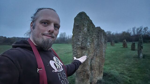
Good news! It’s certainly still possible (though sometimes boggy, in the winter!) to get to The Devil’s Quoits and log this virtual while using only the permitted footpaths, whether
coming from either the North or the South.
You might find that your map hasn’t yet been updated to reflect the approved routes, but you shouldn’t struggle to get here. Just stick to the path and you’ll find the GZ. (And once
I’ve seen how the local controversy resolves itself I’ll be sure to submit updates to OpenStreetMap to accurately reflect the eventual state of the paths around here!)
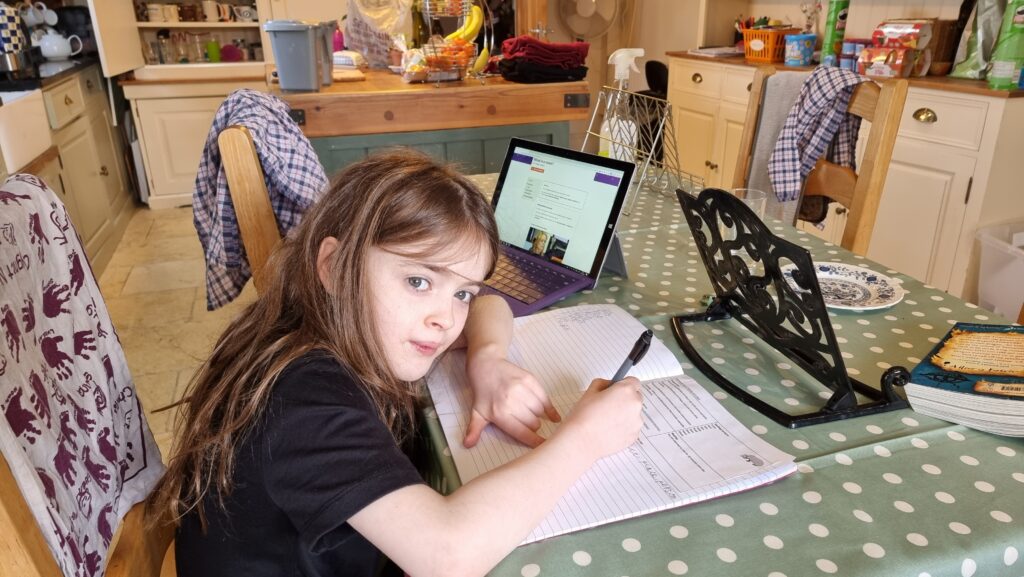
Pretty sure there isn’t a prize for Throwing Wet Sponges At Children during the graduating year’s “fun run” at the school sports day… but just like the kids are asked to, I’m going to
try my best. 😁
As time has gone by, a great many rural English villages have been consumed by their nearest towns, or else become little more than dormitory villages: a place where people do little
more than eat and sleep in-between their commutes to-and-from their distant workplaces1.
And so it pleases me at least a little that the tiny village I’ve lived in for five years this week still shows great success in how well
it clings on to its individual identity.
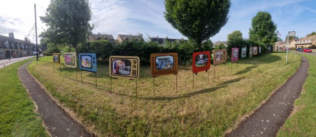
Right now our village green is surrounded by flags, bunting, and thematic decorations.
Every summer since time immemorial, for example, it’s hosted a Village Festival, and this year it feels like the community’s gone all-out. The theme this year is A Century in
Television, and most of the festivities seem to tie-in to the theme.
If you recognise these characters from their first time around on British television, you’re probably older than I am. If you recognise them from their 2001 “reboot”, then you’re probably younger.
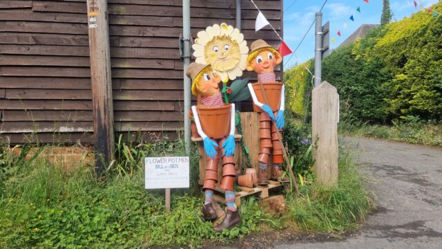
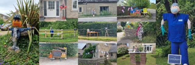
I’ve been particularly impressed this year by entrants into the (themed) scarecrow competition: some cracking scarecrows (and related decorations) have started popping up around the
village in advance of festival week!
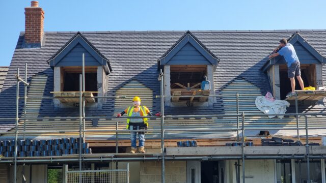
Bob the Builder’s helping out with the reconstruction of the roof of one of the houses down towards the end of my hamlet, just outside the village proper.
There’s a clear bias towards characters from childrens’ television programmes, but that only adds to the charm. Not only does it amuse the kids when we walk by them, but it feeds into
the feeling of nostalgia that the festival theme seems to evoke (as well, perhaps, as a connection to the importance of this strange village tradition).
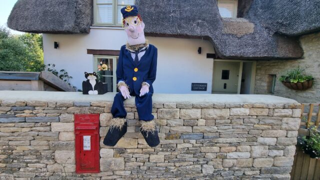
Well-played, Letterbox Cottage. Well-played.
If you took a wrong turning and found your way through our village when you meant to be somewhere else, you’d certainly be amused, bemused, or both by the plethora of figures standing
on street corners, atop hedgerows, and just generally around the place2.
Shaun the Sheep and what I believe must be his cousin Timmy stand atop a hedge looking down on a route used by many children on their way to school.
The festival, like other events in the local calendar, represents a collective effort by the “institutions” of the village – the parish council, the church, the primary school, etc.
But the level of time and emotional investment from individual households (whether they’re making scarecrows for the Summer festival… decorating windows as a Christmas advent calendar…
turning out for a dog show last week, I hear3…)
shows the heart of a collective that really engage with this kind of community. Which is really sweet.
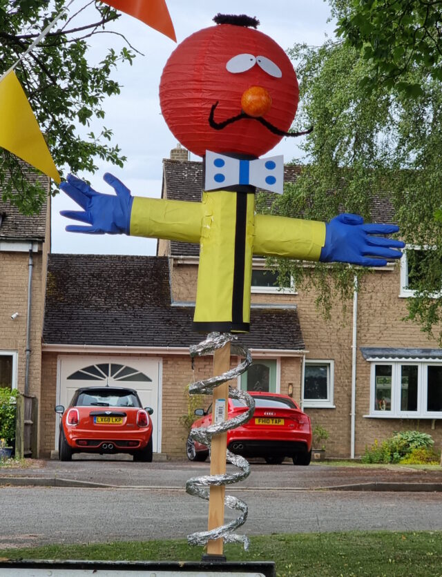
An imaginative use of a coloured lampshade plus some excellent tinfoil work makes Zebedee here come to life. He could only have been more-thematic if he’d been installed on the
village’s (only) roundabout!
Anyway, the short of it is that I feel privileged to live in a village that punches above its weight class when it comes to retaining its distinctive personality. And seeing so many of
my neighbours, near and far, putting these strange scarecrows out, reminded me of that fact.
I’m sure I’m barely scraping the surface – there are definitely a few I know of that I’ve not managed to photograph yet – but there are a lot of scarecrows
around my way, right now.
Footnotes
1 The “village” in which our old house
resided certainly had the characteristic feel of “this used to be a place of its own, but now it’s only-barely not just a residential estate on the outskirts of Oxford, for example.
Kidlington had other features, of course, like Oxford’s short-lived zoological gardens… but it didn’t really feel like it had an identity in
its own right.
2 Depending on exactly which wrong turn you took, the first scarecrow you saw might well
be the one dressed as a police officer – from some nonspecific police procedural drama, one guesses? – that’s stood guard shortly after the first of the signs to advertise our new 20mph speed limit. Holding what I guess is supposed to be a radar gun (but is clearly actually a mini handheld
vacuum cleaner), this scarecrow might well be having a meaningful effect on reducing speeding through our village, and for that alone it might be my favourite.
3 I didn’t enter our silly little furball into the
village dog show, for a variety of reasons: mostly because I had other things to do at the time, but also because she’s a truculent little troublemaker who – especially in the heat of
a Summer’s day – would probably just try to boss-around the other dogs.
Especially outside of urban centres, and especially if you’re on foot, OpenStreetMap is way better than Google Maps, Bing Maps,
Apple Maps, or what-have-you.
The area at the North end of Sutton Lane, near where I live, is mostly just a huge expanse of nothing in Google Maps, but OpenStreetMap shows footpaths, gates, bridges, house names,
driveways, and land use indicators.
OpenStreetMap is especially good for walkers, with its more-comprehensive coverage of public footpaths as well as the ability to drill-down for accessibility information: whether a path
ends in a gate or a stile matters a lot if you can’t climb the latter (or you’re walking with a small-but-muddy dog who’ll need lifting over).
Sure, you don’t get (as much) street view photography. But how often do you use that, anyway?1
Of course, some of the places near me at which OpenStreetMap especially excels are… because of me! A little amateur cartography can go a long way.
I’ve heard it argued that OpenStreetMap, with its Wikipedia-like “anybody can edit it” model, cannot be relied upon. And sure, if you’re looking for an “official” level of accuracy and
the alternative is an Ordinance Survey map, then that’s what you should go for.
But there’s nothing specific to, say, Google Maps that makes it fundamentally more “accurate” for most2
geographic features than OpenStreetMap. The vast of cartographic data on Google Maps is produced by humans, looking at satellite photos, and then tracing the features on them, probably
with AI assistance. And the vast majority of cartographic data on OpenStreetMap is produced… exactly the same way, although without the AI “helping”.
Google Maps has mistakes, just like every map3. And it’s
got trap streets, like most commercially-produced maps (including the Ordinance Survey). Google Maps’ mistakes tend to be made by somebody on the other side of the world
from the feature, doing a bad job of tracing what they think might be a road… while OpenStreetMaps’ mistakes are for the most part omissions in areas that are under-explored by
local contributors. And there are plenty of areas – like those near where I live, especially if you’re on foot – where the latter mistakes are much less-troublesome.
If you’re looking to make a delivery to my village, where most buildings are named rather than numbered, postcode areas are broad, and it’s not always clear where it’ll be safe to
park… you’d do a lot better to use OpenStreetMap than any other digital map.
I fixed a couple of omissions on OpenStreetMap just earlier today. While I was out walking the dog, earlier, I added the names of two houses whose identities weren’t specifically marked on the map, and I
added detail to the newly-constructed Deansfield estate. Google Maps shows there being only
two houses on Deansfield Estate, among other inaccuracies, even though they’ve got up-to-date aerial and street photography.
Google Maps is fine if you want to drive to Sheffield, you need public transport connections to Plymouth4, or you’re looking for a restaurant nearby and you want
the data about them to be accurate. But next time you’re walking somewhere, or when you’re looking for a specific address… I’d suggest you give OpenStreetMap a go. You
might be pleasantly surprised.
Footnotes
1 I say that as somebody who uses street view and satellite photography a more
than average amount, for geohashing purposes. But I can switch mapping software on-the-fly; nobody’s stopping me looking at “ostrich” photos when I need them.
2 The place that Google Maps really beats OpenStreetMap, in my mind, is in the integration
of its business directory. If you search for a business in Google Maps, you’ll probably find it and get reasonably-accurate opening hours and contact details. But that’s a
factor of two things: the Google My Business directory, and – more importantly – the popularity of the application and the fact that the mobile app “nudges” people to check on the
places around them. By the way: if you want to contribute to making maps better in that way without becoming an unpaid researcher working to line Google’s pockets, StreetComplete is an app that helps fill-out business and related information on OpenStreetMap!
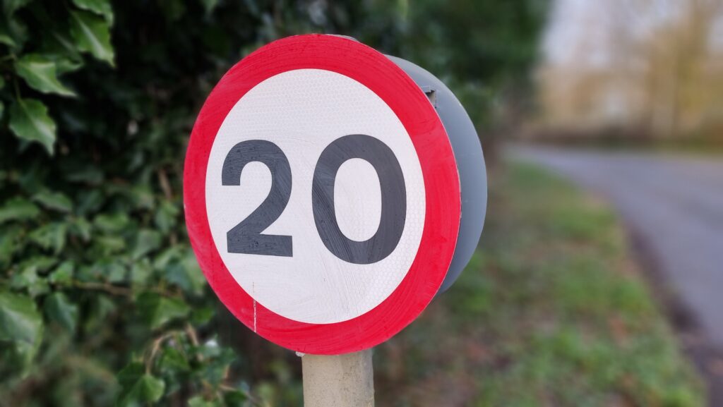
I’ve now confirmed that this cache is missing (it looks like it was removed by the council during the installation of the signs for the new 20mph limit1) and sourced the requisite parts to construct a
like-for-like replacement. I’ll aim to get that constructed and in-place within the next two weeks.
This week, I received a ~240V AC electric shock. I can’t recommend it.
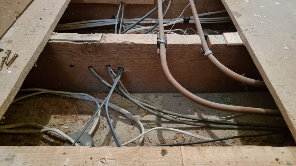
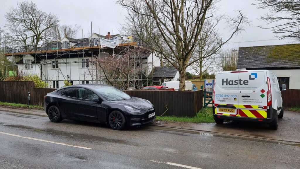
As you may have guessed based on photos in previous posts, our house is currently wrapped in a convenient climbing frame scaffolding.
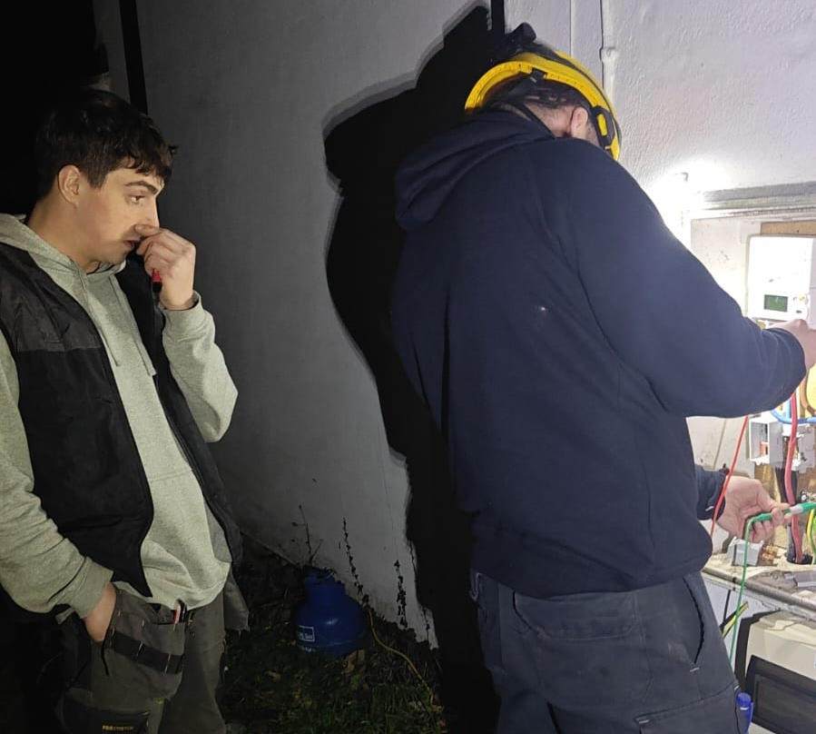
We’re currently having our attic converted, so we’ve had some electricians in doing the necessary electrical wiring. Shortly after they first arrived they discovered that our existing electrics were pretty catastrophic, and needed to make a few changes including a new fusebox and disconnecting the
hilariously-unsafe distribution board in the garage.
The owner before last of our house worked for SSEN and did all of his own wiring, and left us a rats’ nest
of spaghetti wiring that our electricians described as being unlike anything they’d ever seen before. Also a literal rats’ nest under the decking, but we got rid of that already.
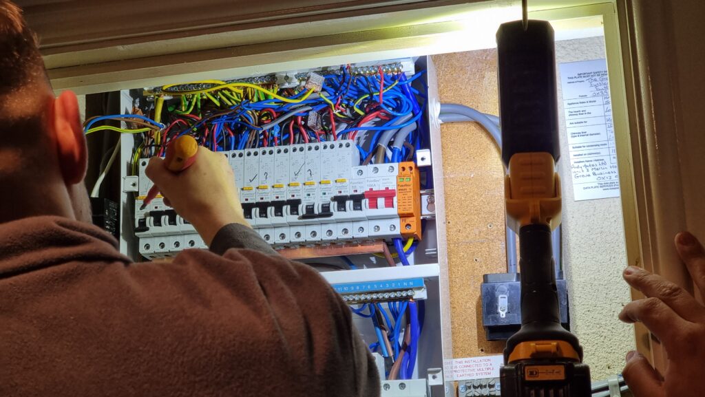
After connecting everything new up they began switching everything back on and testing the circuits… and we were surprised to hear arcing sounds and see all the lights flickering.
The electricians switched everything off and started switching breakers back on one at a time to try to identify the source of the fault, reasonably assuming that something was shorting
somewhere, but no matter what combination of switches were enabled there always seemed to be some kind of problem.
You know those escape room puzzles where you have to get the right permutation of switch combinations? This was a lot less fun than that.
Noticing that the oven’s clock wasn’t just blinking 00:00 (as it would after a power cut) but repeatedly resetting itself to 00:00, I pointed this out to the electricians as an
indicator that the problem was occurring on their current permutation of switches, which was strange because it was completely different to the permutation that had originally exhibited
flickering lights.
I reached over to point at the oven, and the tip of my finger touched the metal of its case…
Blam! I felt a jolt through my hand and up my arm and uncontrollably leapt backwards across the room, convulsing as I fell to the floor. I gestured to the cooker and
shouted something about it being live, and the electricians switched off its circuit and came running with those clever EM-field sensor
pens they use.
Somehow the case of the cooker was energised despite being isolated at the fusebox? How could that be?
Buy one ECG appointment. Get a free partial chest-shaving free!
I missed the next bits of the diagnosis of our electrical system because I was busy getting my own diagnosis: it turns out that if you get a mains electric shock – even if you’re
conscious and mobile – the NHS really want you to go to A&E.
At my suggestion, Ruth delivered me to the Minor Injuries unit at our nearest hospital (I figured that what I had wasn’t that
serious, and the local hospital generally has shorter wait times!)… who took one look at me and told me that I ought to be at the emergency department of the bigger hospital over the
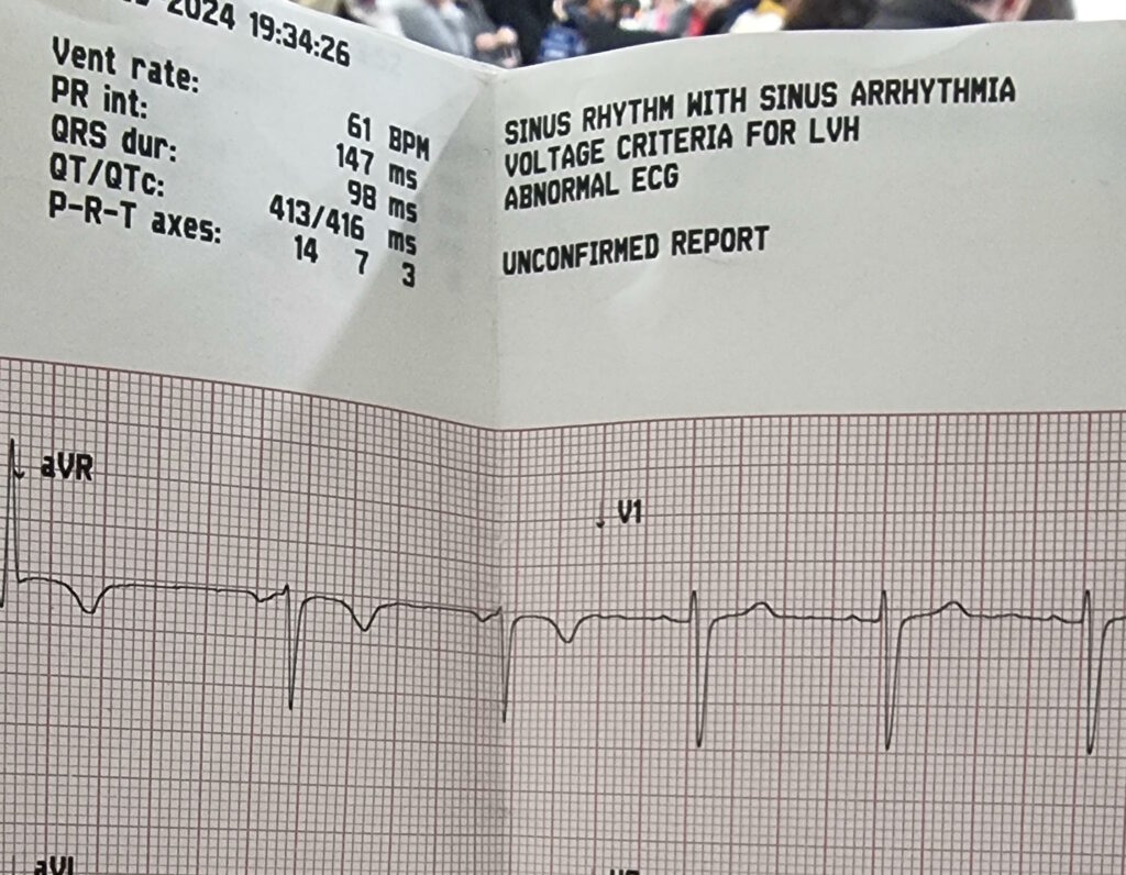
way.
The first hospital were kind enough to hook me up to an ECG before sending me on to the A&E department. It indicated possible cardiac arrhythmia in the sinus node – basically: my heart’s natural pacemaker was firing somewhat
irregularly – which is kinda what you’d expect from an AC zap.
Off at the “right” hospital I got another round of ECG tests, some blood tests (which can apparently be used to diagnose muscular
damage: who knew?), and all the regular observations of pulse and blood pressure and whatnot that you might expect.
And then, because let’s face it I was probably in better condition than most folks being dropped off at A&E, I was left to
chill in a short stay ward while the doctors waited for test results to come through.
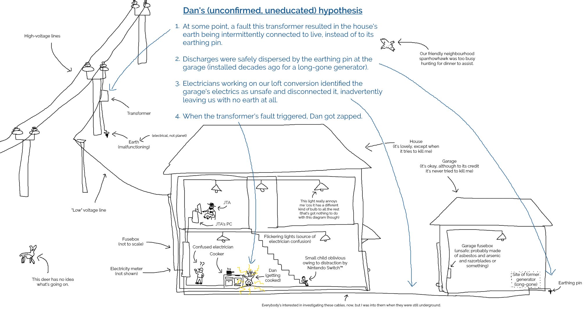
Apparently our electricity meter blew itself up somewhere along the way, leaving us with even less of a chance to turn the power back on again.
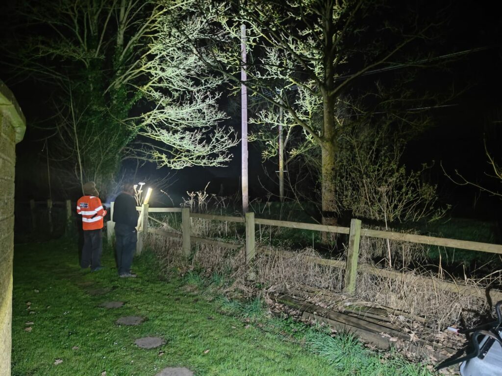
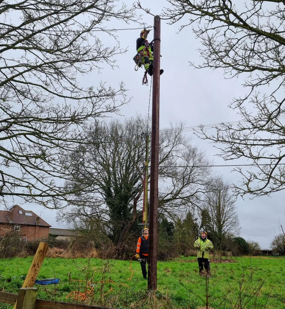
Meanwhile, back at home our electricians had called-in SSEN, who look after the grid in our area. It turns
out that the problem wasn’t directly related to our electrical work at all but had occurred one or two pylons “upstream” from our house. A fault on the network had, from the sounds of
things, resulted in “live” being sent down not only the live wire but up the earth wire too.
That’s why appliances in the house were energised even with their circuit breakers switched-off: they were connected to an earth that was doing pretty-much the opposite of what an earth
should: discharging into the house!
For the next day or so, a parade of linesmen climbed up and down all the pylons in the field behind our house, hunting for the source of the problem.
It seems an inconceivable coincidence to me that a network fault might happen to occur during the downtime during which we happened to have electricians working, so I find myself
wondering if perhaps the network fault had occurred some time ago but only become apparent/dangerous as a result of changes to our household configuration.
I’m no expert, but I sketched a diagram showing how such a thing might happen (click to
embiggen). I’ll stress that I don’t know for certain what went wrong: I’m just basing this on what I’ve been told my SSEN plus a little speculation:
By the time I was home from the hospital the following day, our driveway was overflowing with the vehicles of grid engineers to the point of partially blocking the main street outside
(which at least helped ensure that people obeyed our new 20mph limit for a change).
We weren’t even able to get our own car onto our driveway when we got back from the hospital.
Two and a half days later, I’m back at work and mostly recovered. I’ve still got some discomfort in my left hand, especially if I try to grip anything tightly, but I’m definitely moving
in the right direction.
It’s actually more-annoying how much my chest itches from having various patches of hair shaved-off to make it possible to hook up ECG electrodes!
The actual conversation at this point seemed to consist of the guy at the top of the pole confirming that yes, he really had disconnected the live wire from our house, and
one at the bottom saying he can’t have because he’s still seeing electricity flowing. Makes sense now, doesn’t it?
Anyway, the short of it is that I recommend against getting zapped by the grid. If it had given me superpowers it might have been a different story, but I guess it just gave me
sore muscles and a house with a dozen non-working sockets.
Cache removed and temporarily disabled. The council have just started installing new signage to advise of a new 20mph speed limit around here. 🎉
When they recently did the same in a nearby village, they removed a cache of this type as a (presumably accidental) side effect. I don’t know if this cache’s host is among those that’ll
be affected but I suspect it will so I’ve temporarily removed this one as a precaution and I’ll reinstate it after the works are complete.
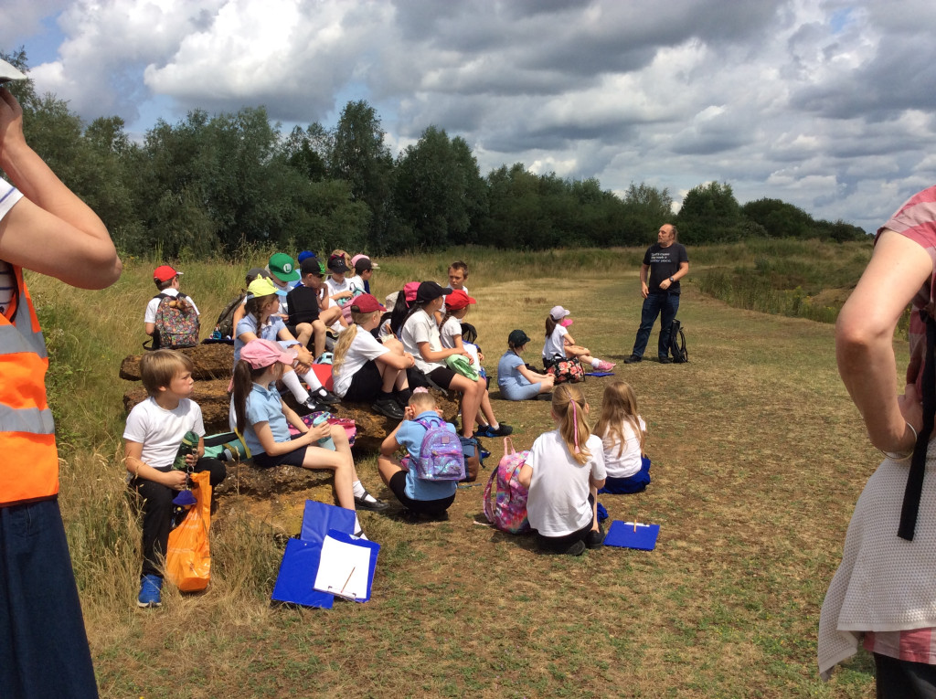
At school, our 9-year-old is currently studying the hsitory of human civilization from the late stone age through to the bronze age. The other week, the class was split into three
groups, each of which was tasked with researching a different piece of megalithic architecture:
One group researched Stonehenge, because it’s a pretty obvious iconic choice
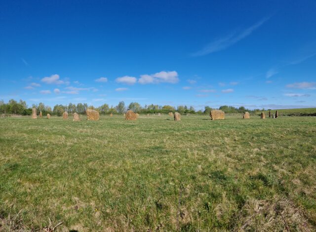
The final group took the least-famous monument, our very own local village henge The Devil’s Quoits
Love me some ancient monuments, even those that are perhaps less authentically-ancient than others.
And so it was that one of our eldest’s classmates was searching on the Web for information about The Devil’s Quoits when they found… my vlog on the subject! One of them recognised me and said, “Hey, isn’t that your Uncle Dan?”1
On the school run later in the day, the teacher grabbed me and asked if I’d be willing to join their school trip to the henge, seeing as I was a “local expert”. Naturally, I said yes,
went along, and told a bunch of kids
what I knew!
I’ve presented to much-larger audiences before on a whole variety of subjects, but this one still might have been the most terrifying.
I was slightly intimidated because the class teacher, Miss Hutchins,
is really good! Coupled with the fact that I don’t feel like a “local expert”2, this became a
kick-off topic for my most-recent coaching session (I’ve mentioned how awesome my coach is before).
I originally thought I might talk to the kids about the Bell Beaker culture people who are believed to have constructed the monument. But when I pitched the idea to our girl she
turned out to know about as much about them as I did, so I changed tack.
I eventually talked to the class mostly about the human geography aspects of the site’s story. The area around the Devil’s Quoits has changed so much over the millenia, and it’s a
fascinating storied history in which it’s been:
A prehistoric henge and a circle of 28 to 36 stones (plus at least one wooden building, at some point).
Medieval farms, from which most of the stones were taken (or broken up) and repurposed.
A brief (and, it turns out, incomplete) archeological survey on the remains of the henge and the handful of stones still-present.
Quarrying operations leaving a series of hollowed-out gravel pits.
More-thorough archeological excavation, backed by an understanding of the cropmarks visible from aircraft that indicate that many prehistoric people lived around this area.
Landfill use, filling in the former gravel pits (except for one, which is now a large lake).
Reconstruction of the site to a henge and stone circle again.3
It doesn’t matter to me that this henge is more a modern reconstruction than a preserved piece of prehistory. It’s still a great excuse to stop and learn about how our ancestors might
have lived.
It turns out that to be a good enough to pass as a “local expert”, you merely have to know enough. Enough to be able to uplift and inspire others, and the humility to know when
to say “I don’t know”.4
That’s a lesson I should take to heart. I (too) often step back from the opportunity to help others learn something new because I don’t feel like I’m that experienced at
whatever the subject is myself. But even if you’re still learning something, you can share what you’ve learned so far and help those behind you to follow the same path.
I’m forever learning new things, and I should try to be more-open to sharing “as I
learn”. And to admit where I’ve still got a long way to go.
Footnotes
1 Of course, I only made the vlog because I was doing a videography course at the time and
needed subject matter, and I’d recently been reading a lot about the Quoits because I was planning on “hiding” a virtual geocache at the site, and then I got carried away. Self-nerdsniped again!
2 What is a local expert? I don’t know, but what I feel like is just a guy who
read a couple of books because he got distracted while hiding a geocache!
3 I’ve no idea what future archeologists will make of this place when they finda
reconstructed stone circle and then, when they dig nearby, an enormous quantity of non-biodegradable waste. What was this strange stone circle for, they’ll ask themselves? Was it a
shrine to their potato-based gods, to whom they left crisp packets as a sacrifice?
4 When we’re talking about people from the neolithic, saying “I don’t know” is pretty
easy, because what we don’t know is quite a lot, it turns out!
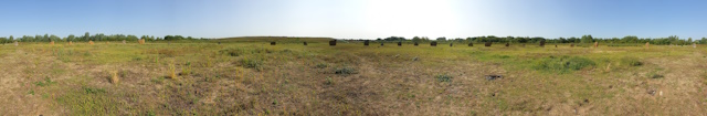
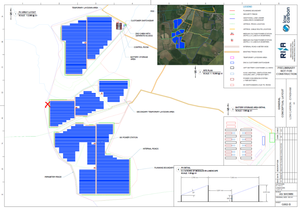
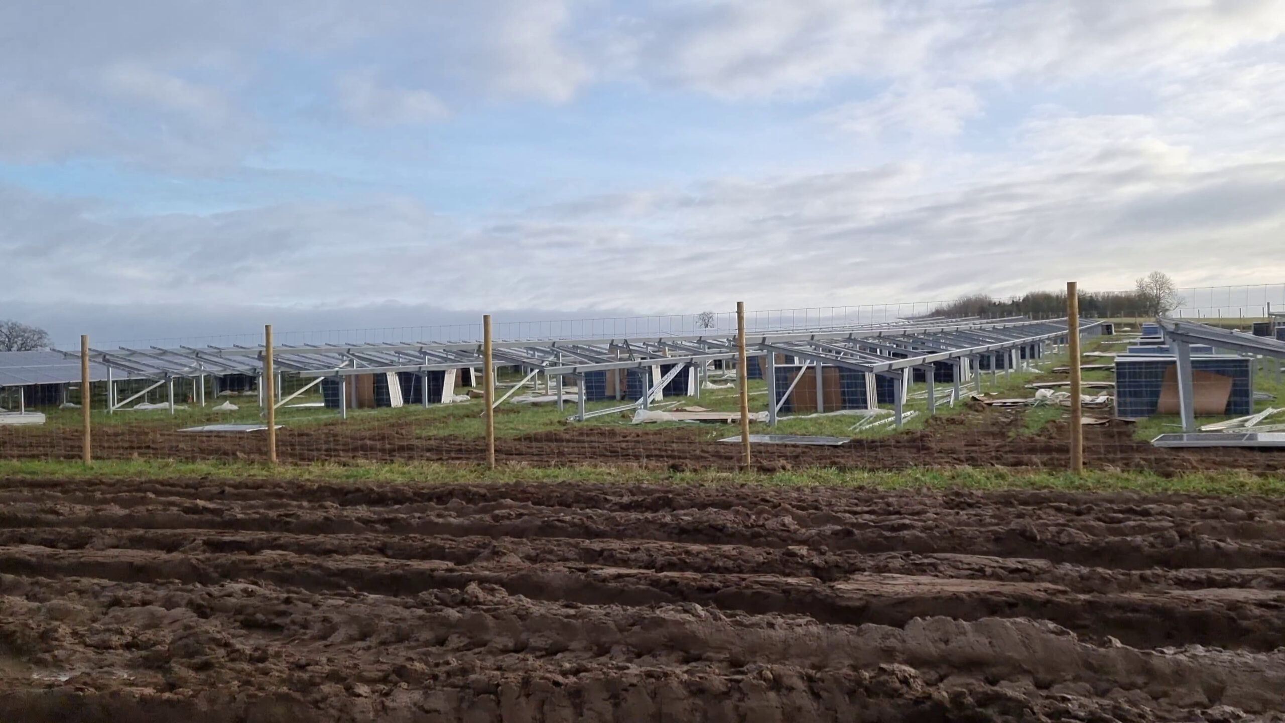
Hashpoint looks like it’s close to the banks of Chill Brook, in the grounds of Twelve Acre Farm. There’s been a lot of changes to the land around here recently owing to the ongoing construction of a new solar
power plant on this land.
Based on planning documents I saw when visiting a presentation about the proposed construction at South Leigh Village Hall last year, I believe the hashpoint is probably
outside the new security fence that’s proposed. I’ve marked the anticipated location of the hashpoint on the diagram below:
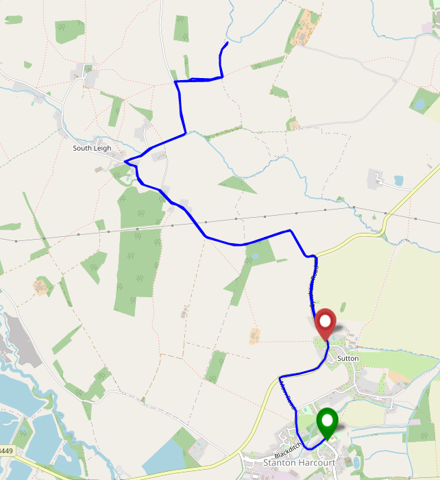
Work-permitting, I plan to cycle out to the trailhead at 51.7774,
-1.41957, lock my bike to the “public footpath” sign, cross the footbridge to the East, and trek out to see if the hashpoint itself is accessible. Not sure when I’ll find time,
though: it’s a busy week for both work and home life!
Expedition
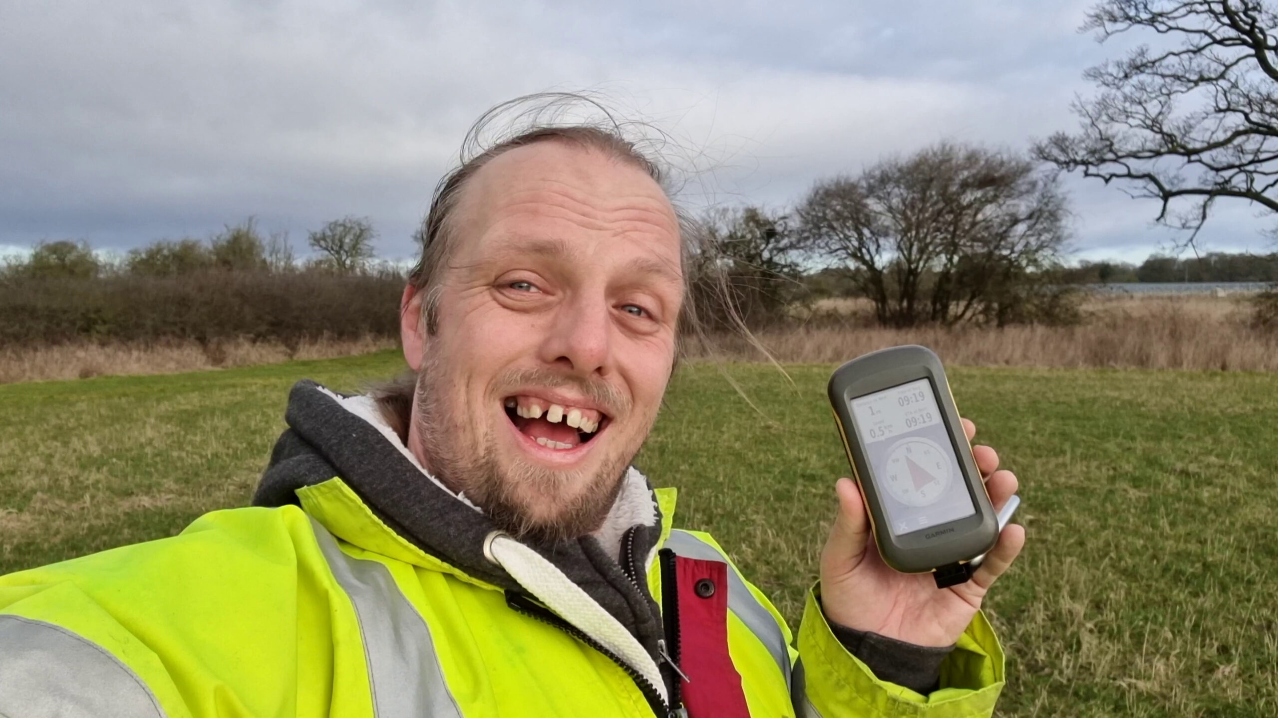
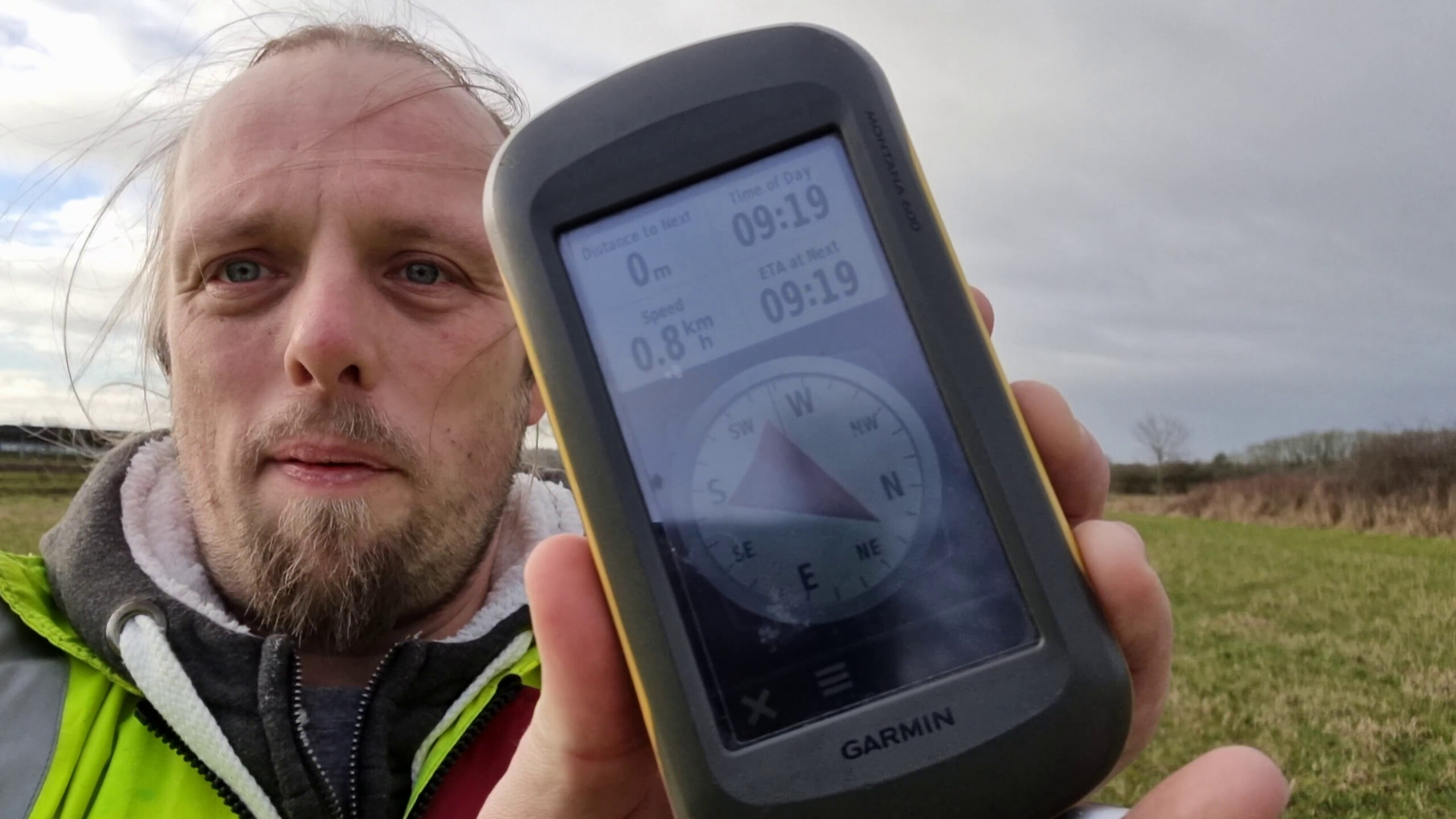
I was really sceptical that I’d be able to make it to this hashpoint: with so much construction going on near the GZ and the fact that it
seems pretty ambiguous whether the hashpoint would be inside or outside the fence. With no reliable maps yet existing of the area covered by this new power plant (the best I could find
were planning documents, which did not have accurate grid references but instead used field boundaries as markers), I knew from the outset that it could go either way.
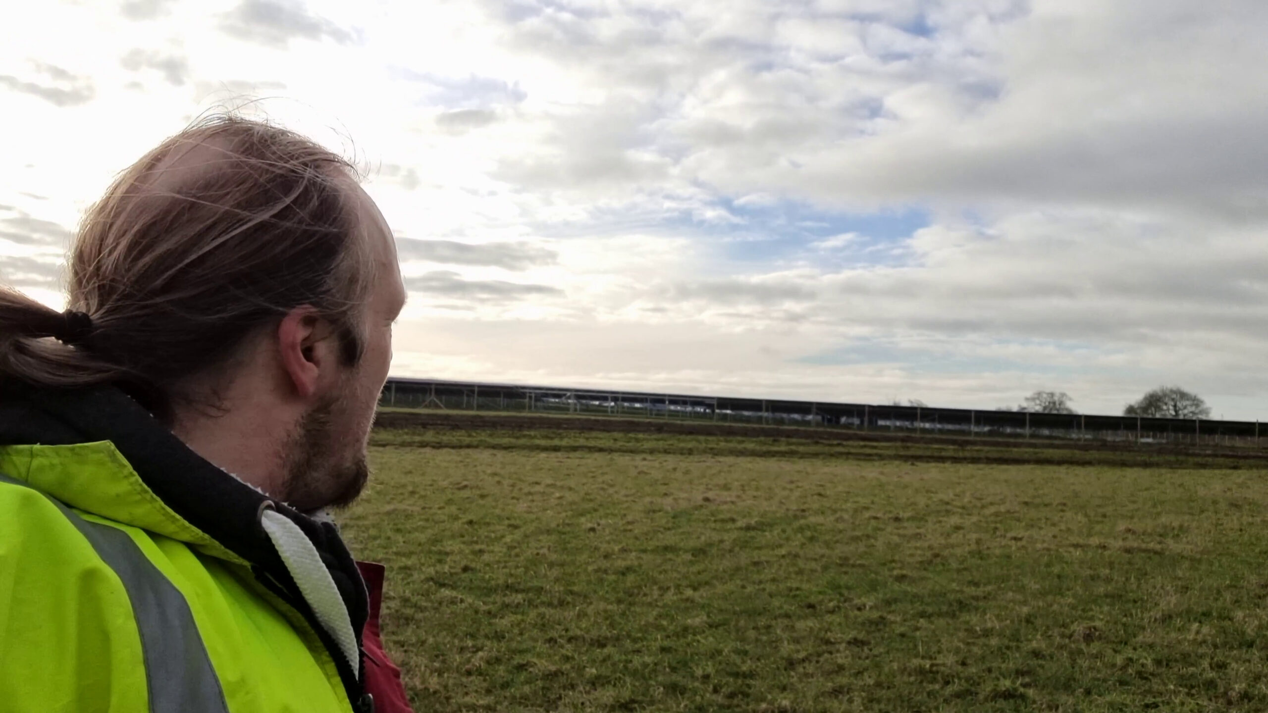
After dropping the kids at school I cycled past my house and on, through South Leigh and up to the start of the footpath that runs closest to the new construction. I locked up my bike
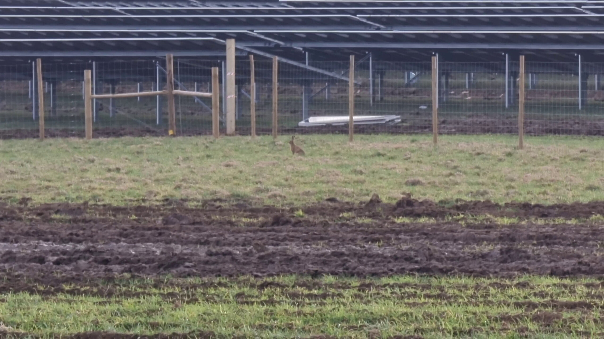
and continued on foot, at least slightly awed by the scale of construction ahead of me: this new solar power plant feels pretty massive! Diverting along the edge of the new fence that’s
been erected to mark the boundary of the Northernmost part of the site, I was delighted to discover that the hashpoint was very-definitely outside the site itself: fantastic! I
reached the GZ at 09:20, then turned around to head back home to work.
I shot the whole expedition on video, which I’ve condensed to a 3 minute 19 second video you can watch below. Apologies for the wind noise.
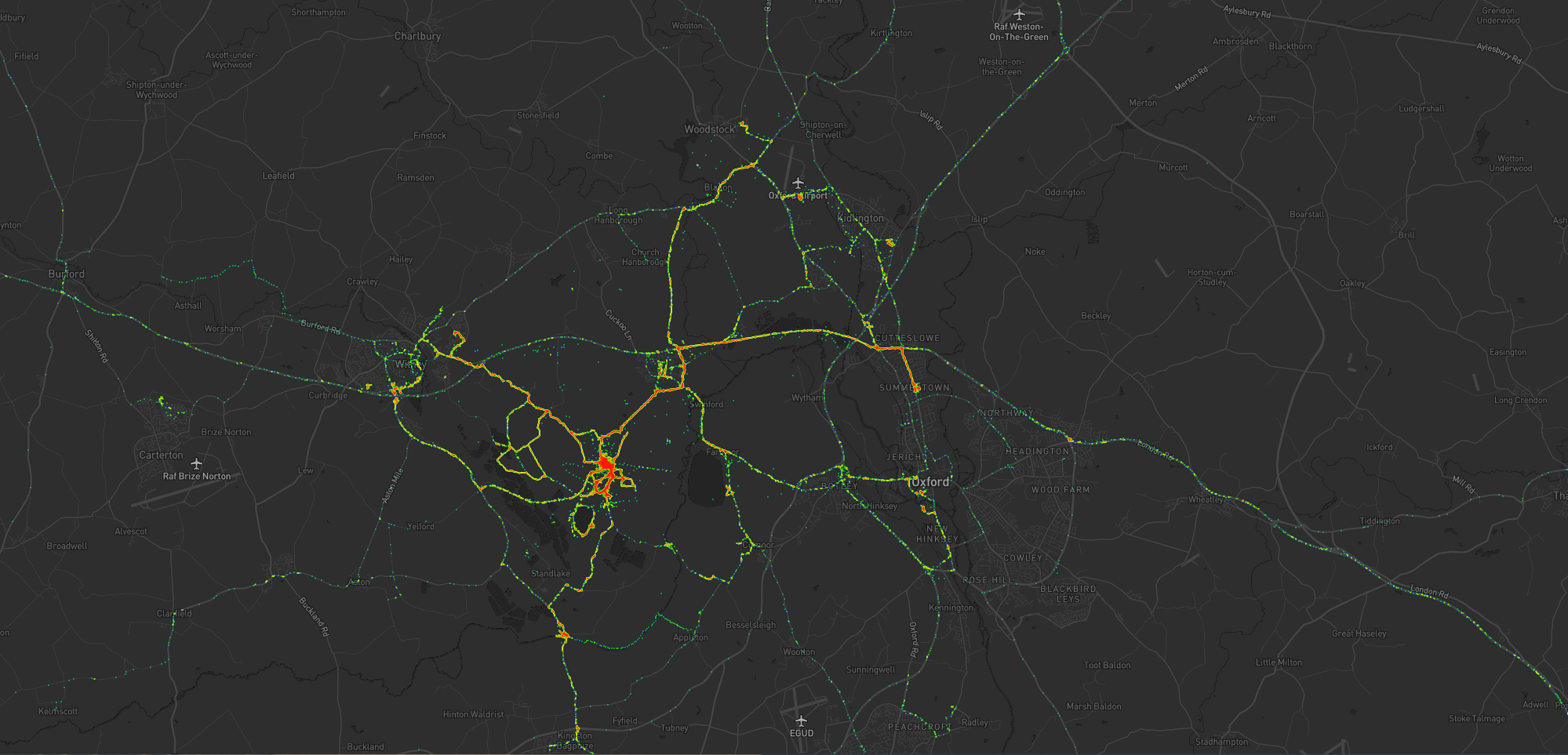
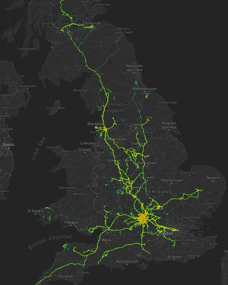
As I mentioned last year, for several years I’ve collected pretty complete historic location data from GPSr devices I carry with me everywhere, which I collate in a personal μlogger server.
Going back further, I’ve got somewhat-spotty data going back a decade, thanks mostly to the fact that I didn’t get around to opting-out of Google’s location tracking until only a few years ago (this data is now
also housed in μlogger). More-recently, I now also get tracklogs from my smartwatch, so I’m managing to collate more personal
location data than ever before.
The blob around my house, plus some of the most common routes I take to e.g. walk or cycle the children to school.
A handful of my favourite local walking and cycling routes, some of which stand out very well: e.g. the “loop” just below the big blob represents a walk around the lake at Dix Pit;
the blob on its right is the Devils Quoits, a stone circle and henge that I thought were sufficiently interesting that
I made a virtual geocache out of them.
The most common highways I spend time on: two roads into Witney, the road into and around Eynsham, and routes to places in Woodstock and North Oxford where the kids have often had
classes/activities.
I’ve unsurprisingly spent very little time in Oxford City Centre, but when I have it’s most often been at the Westgate Shopping Centre,
on the roof of which is one of the kids’ favourite restaurants (and which we’ve been able to go to again as Covid restrictions have lifted, not least thanks to their outdoor seating!).
One to eight years ago
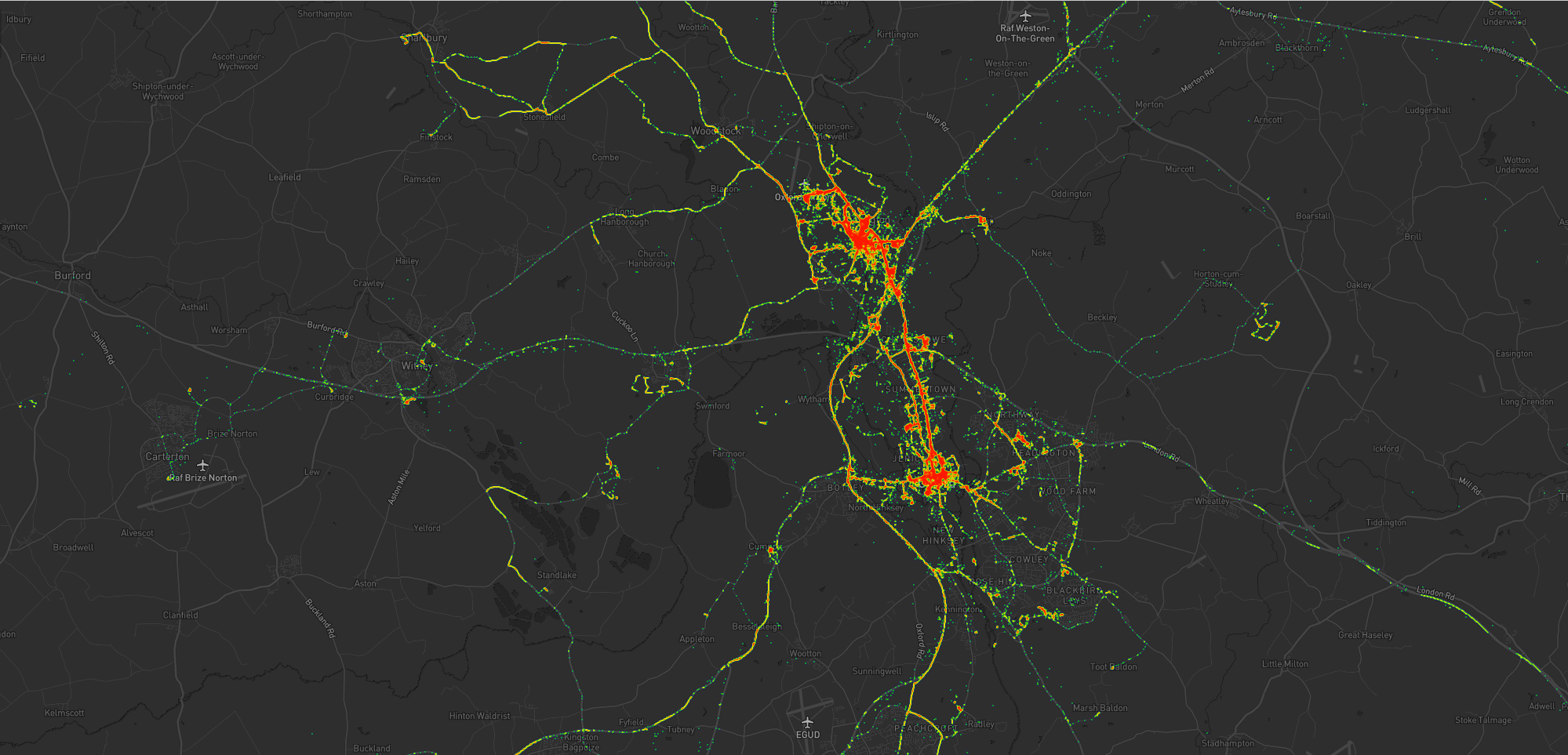
Let’s go back to the 7 years prior, when I lived in Kidlington. This paints a different picture:
For the seven years I lived in Kidlington I moved around a lot more than I have since: each hotspot tells a story, and some tell a few.
This heatmap highlights some of the ways in which my life was quite different. For example:
Most of my time was spent in my village, but it was a lot larger than the hamlet I live in now and this shows in the size of my local “blob”. It’s also possible to pick out common
destinations like the kids’ nursery and (later) school, the parks, and the routes to e.g. ballet classes, music classes, and other kid-focussed hotspots.
I worked at the Bodleian from early 2011 until late in 2019, and so I spent a lot of time in
Oxford City Centre and cycling up and down the roads connecting my home to my workplace: Banbury Road glows the brightest, but I spent some time on Woodstock Road too.
For some of this period I still volunteered with Samaritans in Oxford, and their branch – among other volunteering hotspots
– show up among my movements. Even without zooming in it’s also possible to make out individual venues I visited: pubs, a cinema, woodland and riverside walks, swimming pools etc.
Less-happily, it’s also obvious from the map that I spent a significant amount of time at the John Radcliffe Hospital, an unpleasant reminder of some challenging times from that
chapter of our lives.
The data’s visibly “spottier” here, mostly because I built the heatmap only out of the spatial data over the time period, and not over the full tracklogs (i.e. the map it doesn’t
concern itself with the movement between two sampled points, even where that movement is very-guessable), and some of the data comes from less-frequently-sampled sources like Google.
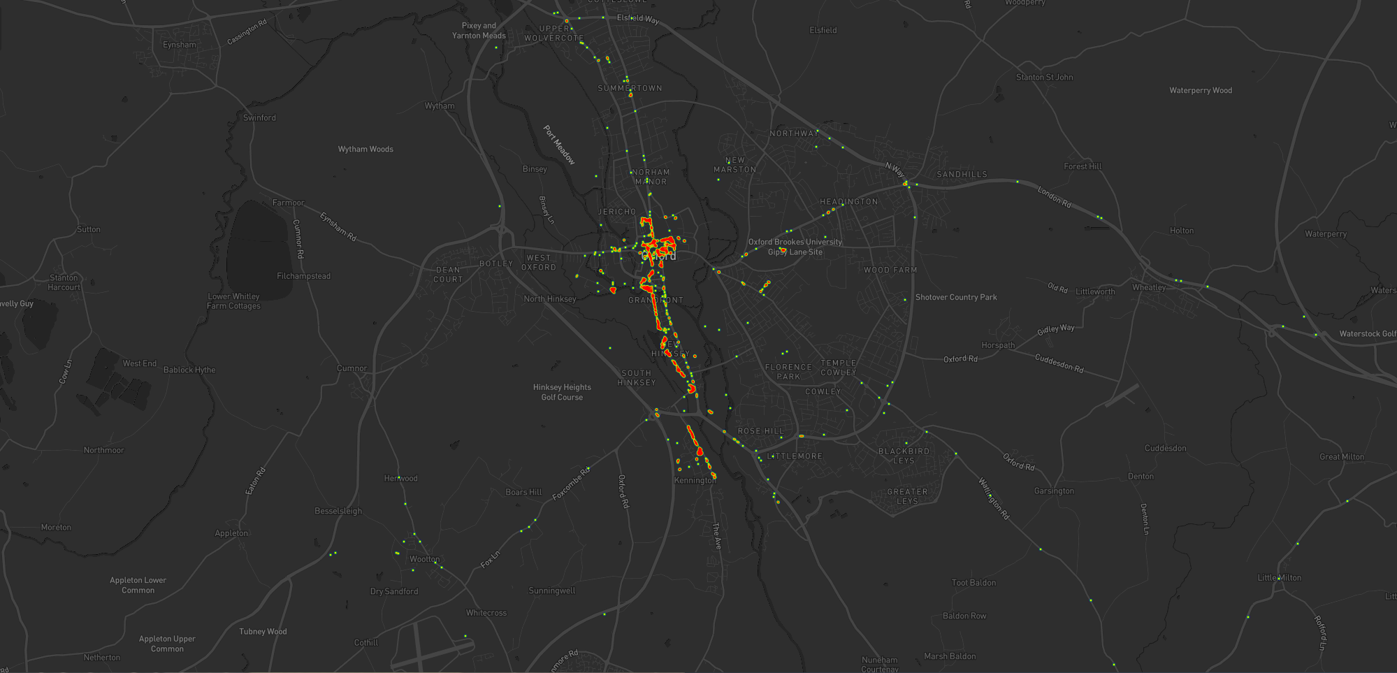
Eight to ten years ago
Let’s go back further:
Back when I lived in Kennington I moved around a lot less than I would come to later on (although again, the spottiness of the data makes that look more-significant than it is).
Before 2011, and before we bought our first house, I spent a couple of years living in Kennington, to the South of Oxford. Looking at
this heatmap, you’ll see:
I travelled a lot less. At the time, I didn’t have easy access to a car and – not having started my counselling qualification yet – I
didn’t even rent one to drive around very often. You can see my commute up the cyclepath through Hinksey into the City Centre, and you can even make out the outline of Oxford’s Covered
Market (where I’d often take my lunch) and a building in Osney Mead where I’d often deliver training courses.
Sometimes I’d commute along Abingdon Road, for a change; it’s a thinner line.
My volunteering at Samaritans stands out more-clearly, as do specific venues inside Oxford: bars, theatres, and cinemas – it’s the kind of heatmap that screams “this person doesn’t
have kids; they can do whatever they like!”
Every map tells a story
I really love maps, and I love the fact that these heatmaps are capable of painting a picture of me and what my life was like in each of these three distinct chapters of my life over
the last decade. I also really love that I’m able to collect and use all of the personal data that makes this possible, because it’s also proven useful in answering questions like “How
many times did I visit Preston in 2012?”, “Where was this photo taken?”, or “What was the name of that place we had lunch when we got lost during our holiday in Devon?”.
There’s so much value in personal geodata (that’s why unscrupulous companies will try so hard to steal it from you!), but sometimes all you want to do is use it to draw pretty heatmaps.
And that’s cool, too.
How these maps were generated
I have a μlogger instance with the relevant positional data in. I’ve automated my process, but the essence of it if you’d like to try it yourself is as follows:
First, write some SQL to extract all of the position data you need. I round off the latitude and longitude to 5 decimal places to help “cluster” dots for frequency-summing, and I raise
the frequency to the power of 3 to help make a clear gradient in my heatmap by making hotspots exponentially-brighter the more popular they are:
This data needs converting to JSON. I was using Ruby’s mysql2 gem to
fetch the data, so I only needed a .to_json call to do the conversion – like this:
db =Mysql2::Client.new(host: ENV['DB_HOST'], username: ENV['DB_USERNAME'], password: ENV['DB_PASSWORD'], database: ENV['DB_DATABASE'])
db.query(sql).to_a.to_json
Approximately following this guide and leveraging my Mapbox
subscription for the base map, I then just needed to include leaflet.js, heatmap.js, and leaflet-heatmap.js before writing some JavaScript code
like this:
body.innerHTML ='<div id="map"></div>';
let map = L.map('map').setView([51.76, -1.40], 10);
// add the base layer to the map
L.tileLayer('https://api.mapbox.com/styles/v1/{id}/tiles/{z}/{x}/{y}?access_token={accessToken}', {
maxZoom:18,
id:'itsdanq/ckslkmiid8q7j17ocziio7t46', // this is the style I defined for my map, using Mapbox
tileSize:512,
zoomOffset:-1,
accessToken:'...'// put your access token here if you need one!
}).addTo(map);
// fetch the heatmap JSON and render the heatmap
fetch('heat.json').then(r=>r.json()).then(json=>{
let heatmapLayer =new HeatmapOverlay({
"radius":parseFloat(document.querySelector('#radius').value),
"scaleRadius":true,
"useLocalExtrema":true,
});
heatmapLayer.setData({ data: json });
heatmapLayer.addTo(map);
});
Visited to check on this new cache: especially as the container is a new design I wanted to do an early checkin to ensure it’s bedded in nicely. Glad to say all is well! Also dropped
off Paul The Sea Horse, a Travel Bug I found up in Derbyshire who’s still got a
couple of years exploring left in him before he completes his ten year mission! Please help him move along if you can.
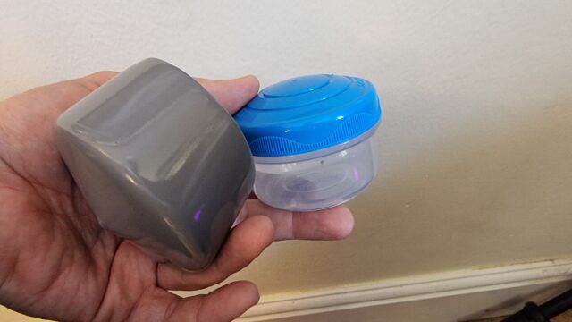
For GC9EXXX Church Micro 14129…Sutton, a geocache I recently set up, I wanted to use a “pole topper”
style cache. I’ve always felt slightly let down by finding yet another magnetic nano stuck inside a pipe, so I wanted to do something better. You can watch the video here or on YouTube, or scroll down for written instructions.
Sand down the lid and the inside of the pole topper so the glue adheres to it better.
Mix up your 2-part epoxy in the pole topper. Don’t use too much or it’ll overflow and block the lid from closing.
Put the lid into the pole topper and press down firmly and evenly to squeeze out any air bubbles.
While you’re waiting for the epoxy to set, file off the flange around the edge of the tub. It’s there to catch drips but
you’re not going to be storing food anyway! The lid is easier to take on and off with the flange filed away.
Finally, roughen the bottom edge of the tub with some sandpaper to make it easier to grip when opening and closing the
container.
Music:
For Lorilyn by Casey LaLonde, used under a CC-NC Creative Commons License.