I can’t begin to fathom the courage it takes to get on-stage in front of an ultra-conservative crowd (well, barely a crowd…) in a right-leaning US state to protest their
event by singing a song about a trans boy. But that’s exactly what Hamrick did. After
catching spectators off-guard, perhaps, by taking the perhaps-“masculine-telegraphing” step of drawing attention to part of his army uniform, the singer swiftly switched outfit to show
off a “Keep Canyon County Queer” t-shirt, slip on a jacket with various Pride-related patches, and then immediately launched into Boy, a song lamenting the persecution of
a trans child by their family and community.
Needless to say, this was the first, last, and only song Daniel Hamrick got to play at Hetero Awesome Fest. But man, what a beautiful protest!
(There are other videos online that aren’t nabbed from the official event feed and so don’t cut-out abruptly.)
I still get that powerful feeling that anything is possible when I open a web browser — it’s not as strong as it was 20 years ago, but it’s still there.
As cynical as you can get at the state of the Web right now… as much as it doesn’t command the level of inspirational raw potential of “anything is possible” that it might have once…
it’s still pretty damn magical, and we should lean into that.
A freaking excellent longread by Eevee (Evelyn Woods), lamenting the direction of popular technological progress and general enshittification of creator culture. It’s ultimately
uplifting, I feel, but it’s full of bitterness until it gets there. I’ve pulled out a couple of highlights to try to get you interested, but you should just go and read the entire thing:
…
And so the entire Web sort of congealed around a tiny handful of gigantic platforms that everyone on the fucking planet is on at once. Sometimes there is some sort of
partitioning, like Reddit. Sometimes there is not, like Twitter.
That’s… fine, I guess. Things centralize. It happens. You don’t get tubgirl spam raids so much any more, at least.
But the centralization poses a problem. See, the Web is free to look at (by default), but costs money to host. There are free hosts, yes, but those are for static
things getting like a thousand visitors a day, not interactive platforms serving a hundred million. That starts to cost a bit. Picture logs being shoveled into a steam
engine’s firebox, except it’s bundles of cash being shoveled into… the… uh… website hole.
…
I don’t want to help someone who opens with “I don’t know how to do this so I asked ChatGPT and it gave me these 200 lines but it doesn’t work”. I don’t want to know how much code
wasn’t actually written by anyone. I don’t want to hear how many of my colleagues think Whatever is equivalent to their own output.
…
I glimpsed someone on Twitter a few days ago, also scoffing at the idea that anyone would decide not to use the Whatever machine. I can’t remember exactly what they said,
but it was something like: “I created a whole album, complete with album art, in 3.5 hours. Why wouldn’t I use the make it easier machine?”
This is kind of darkly fascinating to me, because it gives rise to such an obvious question: if anyone can do that, then why listen to your music? It takes a
significant chunk of 3.5 hours just to listen to an album, so how much manual work was even done here? Apparently I can just go generate an endless stream of stuff of the
same quality! Why would I want your particular brand of Whatever?
Nobody seems to appreciate that if you can make a computer do something entirely on its own, then that becomes the baseline.
…
Do things. Make things. And then put them on your website so I can see them.
Clearly this all ties in to stuff that I’ve been thinking, lately. Expect more
posts and reposts in this vein, I guess?
Do you remember when your domestic ISP – Internet Service Provider – used to be an Internet Services Provider? They
were only sometimes actually called that, but what I mean is: when ISPs provided more than one Internet service? Not just connectivity, but… more.
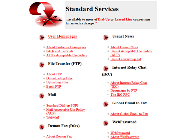
One of the first ISPs I subscribed to had a “standard services” list longer than most modern ISPs complete services list!
ISPs twenty years ago
It used to just be expected that your ISP would provide you with not only an Internet connection, but also some or all of:
I don’t remember which of my early ISPs gave me a free license for HoTMetaL Pro, but I was very appreciative of it at the time.
ISPs today
The ISP I hinted at above doesn’t exist any more, after being bought out and bought out and bought out by a series of owners. But I checked the Website of the current owner to see what
their “standard services” are, and discovered that they are:
Optional 4G backup connectivity (for an extra fee)
A voucher for 3 months access to a streaming service3
The connection is faster, which is something, but we’re still talking about the “baseline” for home Internet access then-versus-now. Which feels a bit galling, considering that (a)
you’re clearly, objectively, getting fewer services, and (b) you’re paying more for them – a cheap basic home Internet subscription today, after accounting
for inflation, seems to cost about 25% more than it did in 2000.4
Are we getting a bum deal?
Not every BBS nor ISP would ever come to support the blazing speeds of a 33.6kbps modem… but when you heard the distinctive scream of its negotiation at close to the Shannon Limit of
the piece of copper dangling outside your house… it felt like you were living in the future.
Would you even want those services?
Some of them were great conveniences at the time, but perhaps not-so-much now: a caching server, FTP site, or IRC node in the building right at the end of my
dial-up connection? That’s a speed boost that was welcome over a slow connection to an unencrypted service, but is redundant and ineffectual today. And if you’re still using a
fax-to-email service for any purpose, then I think you have bigger problems than your ISP’s feature list!
Some of them were things I wouldn’t have recommend that you depend on, even then: tying your email and Web hosting to your connectivity provider traded
one set of problems for another. A particular joy of an email address, as opposed to a postal address (or, back in the day, a phone number), is that it isn’t tied to where
you live. You can move to a different town or even to a different country and still have the same email address, and that’s a great thing! But it’s not something you can
guarantee if your email address is tied to the company you dial-up to from the family computer at home. A similar issue applies to Web hosting, although for a true traditional “personal
home page”: a little information about yourself, and your bookmarks, it would be fine.
But some of them were things that were actually useful and I miss: honestly, it’s a pain to have to use a third-party service for newsgroup
access, which used to be so-commonplace that you’d turn your nose up at an ISP that didn’t offer it as standard. A static IP being non-standard on fixed connections is a sad reminder
that the ‘net continues to become less-participatory, more-centralised, and just generally more watered-down and shit: instead of your connection making you “part of” the Internet,
nowadays it lets you “connect to” the Internet, which is a very different experience.5
A page like this used to be absolutely standard on the Website6
of any ISP worth its salt.
Yeah, sure, you can set up a static site (unencumbered by any opinionated stack) for free on Github Pages, Neocities, or wherever, but the barrier to entry has been raised
by just enough that, doubtless, there are literally millions of people who would have taken that first step… but didn’t.
And that makes me sad.
Footnotes
1 ISP-provided shared FTP servers would also frequently provide locally-available copies
of Internet software essentials for a variety of platforms. This wasn’t just a time-saver – downloading Netscape Navigator from your ISP rather than from half-way across the world was
much faster! – it was also a way to discover new software, curated by people like you: a smidgen of the feel of a well-managed BBS, from the comfort of your local ISP!
2 ISP-provided routers are, in my experience, pretty crap 50% of the time… although
they’ve been improving over the last decade as consumers have started demanding that their WiFi works well, rather than just works.
3 These streaming services vouchers are probably just a loss-leader for the streaming
service, who know that you’ll likely renew at full price afterwards.
4 Okay, in 2000 you’d have also have had to pay per-minute for the price of the
dial-up call… but that money went to BT (or perhaps Mercury or KCOM), not to your ISP. But my point still stands: in a world where technology has in general gotten cheaper
and backhaul capacity has become underutilised, why has the basic domestic Internet connection gotten less feature-rich and more-expensive? And often with worse
customer service, to boot.
5 The problem of your connection not making you “part of” the Internet is multiplied if
you suffer behind carrier-grade NAT, of course. But it feels like if we actually cared enough to commit to rolling out IPv6 everywhere we could obviate the need for that particular
turd entirely. And yet… I’ll bet that the ISPs who currently use it will continue to do so, even as the offer IPv6 addresses as-standard, because they buy into their own idea that
it’s what their customers want.
6 I think we can all be glad that we no longer write “Web Site” as two separate words, but
you’ll note that I still usually correctly capitalise Web (it’s a proper noun: it’s the Web, innit!).
Some time in the last 25 years, ISPs stopped saying they made you “part of” the Internet, just that they’d help you “connect to” the Internet.
Most people don’t need a static IP, sure. But when ISPs stopped offering FTP and WWW hosting as a standard feature (shit though it often was), they became part of the tragic process by
which the Internet became centralised, and commoditised, and corporate, and just generally watered-down.
The amount of effort to “put something online” didn’t increase by a lot, but it increased by enough that millions probably missed-out on the opportunity to create
their first homepage.
In my first few weeks at my new employer, my code contributions have added 218 lines of code, deleted 2,663. Only one of my PRs has resulted in
a net increase in the size of their codebases (by two lines).
I need to pick up the pace if I’m going to reach the ultimate goal of deleting ALL of the code within my lifetime. (That’s the ultimate aim, right?)
RFC 2119 establishes language around requirement levels. Terms like “MUST”, “MUST NOT”, “SHOULD”, and “SHOULD NOT” are helpful when coordinating with engineers. I reference it a lot
for work, as I create a lot of accessible component
specifications.
Because of this familiarity—and because I’m an ass—I fired back in Discord:
I want to hire a voice actor to read 2119 in the most over the top, passive-aggressive way possible
wait, this is an achievable goal oh no
It turns out you can just pay people to do things.
I found a voice actor and hired them with the task of “Reading this very dry technical document in the most over-the-top sarcastic, passive-aggressive, condescending way possible.
Like, if you think it’s too much, take that feeling, ignore it, and crank things up one more notch.”
…
RFC 2119 is one of few RFCs I can identify by number alone, too. That and RFCs 1945 and 1866, for some reason, and RFC 2822 (and I guess, by proxy, 822) because I’ve had to implement its shitty date format more times than I’d like to count.
A Castle Built From Random Rooms is a work in progress/early access/demo version of a full game that’ll probably never exist. But if it does exist, it will be
basically the same as this, but on a grander scale, and include the following features:
– over a hundred random rooms instead of about ten
– character jobs and descriptions that actually add individualised effects/skills/starting equipment and so on
– special pre-chosen characters with particulalrly challenging stats levels for extra difficult challenges
– more stats! more items! more use of the stats and items within different rooms to create different outcomes!
– high scores and loot rankings and possibly even achievements of some kind
– less bugs (aspiration)
– decent endings (stretch goal)
What the game almost certainly won’t ever have:
– any semblance of quality or coherence
– sound and/or music
– monetary success
It’s a Twine-like choose-your-own-adventure, but with the rooms randomly shuffled each time, in sort-of a semi-rougelite way. Some imaginative work in this. And the art style is
wonderful!
A quesapizza is a quesadilla, but made using pizza ingredients: not just cheese, but also a tomato sauce and maybe some toppings.
A quesapizza-pizza is a pizza… constructed using a quesapizza as its base. Quick to make and pretty delicious, it’s among my go-to working lunches.
The one you see above (and in the YouTube version of this video) is topped with a baked egg and chilli flakes. It might not be
everybody’s idea of a great quesapizza-pizza, but I love mopping up the remainder of the egg yolk with the thick-stuffed cheese and tomato wraps. Mmm!
The elder of our two cars is starting to exhibit a few minor, but annoying, technical faults. Like: sometimes the Bluetooth connection to your phone will break and instead of music, you
just get a non-stop high-pitched screaming sound which you can suppress by turning off the entertainment system… but can’t fix without completely rebooting the entire car.
There’ve been other “this car is getting a bit older” technical faults too. One of his tyre pressure sensors broke the other month and caused a cascade of unrelated errors that
disabled the traction control, ABS, auto-handbrake, parking sensors, and reversing camera… but replacing the pressure sensor fixed everything. Cars are weird, and that’s coming from
somebody working in an industry that fully embraces knock-on regression bugs as a fact of life.
The “wouldn’t you rather listen to screaming” problem occurred this morning. At the time, I was driving the kids to an activity camp, and because they’d been quite enjoying singing
along to a bangin’ playlist I’d set up, they pivoted into their next-most-favourite car journey activity of trying to snipe at one another1.
So I needed a distraction. I asked:
We’ve talked about homonyms and homophones before, haven’t we? I wonder: can anybody think of a pair of words that are homonyms that are nothomophones? So: two words that are spelled the same, but mean different things and sound different when you say
them?
This was sufficiently distracting that it not only kept the kids from fighting for the entire remainder of the journey, but it also distracted me enough that
I missed the penultimate turning of our journey and had to double-back2
…in English
With a little prompting and hints, each of the kids came up with one pair each, both of which exploit the pronunciation ambiguity of English’s “ea” phoneme:
Lead, as in:
/lɛd/ The pipes are made of lead.
/liːd/ Take the dog by her lead.
Read, as in:
/ɹɛd/ I read a great book last month.
/ɹiːd/ I will read it after you finish.
These are heterophonic homonyms: words that sound different and mean different things, but are spelled the same way. The kids and I only came up with the two on our car
journey, but I found many more later in the day. Especially, as you might see from the phonetic patterns in this list, once I started thinking about which other sounds are ambiguous
when written:
Tear (/tɛr/ | /tɪr/): she tears off some paper to wipe her tears away.
Wind(/waɪnd/ |/wɪnd/): don’t forget to wind your watch before you wind your horn.
Live (/laɪv/ | /lɪv/): I’d like to see that band live if only I could live near where they play.
Bass (/beɪs/ | /bæs/): I play my bass for the bass in the lake.
Bow (/baʊ/ | /boʊ/): take a bow before you notch an arrow into your bow.
Sow (/saʊ/ | /soʊ/): the pig and sow ate the seeds as fast as I could sow them.
Does (/dʌz/ | /doʊz/): does she know about the bucks and does in the forest?
(If you’ve got more of these, I’d love to hear read them!)
…in other Languages?
I’m interested in whether heterophonic homonyms are common in any other languages than English? English has a profound advantage for this kind of wordplay3, because it has weakly phonetics (its orthography is irregular: things
aren’t often spelled like they’re said) and because it has diverse linguistic roots (bits of Latin, bits of Greek, some Romance languages, some Germanic languages, and a smattering of
Celtic and Nordic languages).
With a little exploration I was able to find only two examples in other languages, but I’d love to find more if you know of any. Here are the two I know of already:
In French I found couvent, which works only thanks to a very old-fashioned word:
/ku.vɑ̃/ means convent, as in – where you keep your nuns, and
/ku.və/ means sit on, but specifically in the manner that a bird does on its egg, although apparently this usage is considered archaic and the word
couver is now preferred.
In Portugese I cound pelo, which works only because modern dialects of Portugese have simplified or removed the diacritics that used to differentiate the
spellings of some words:
/ˈpe.lu/ means hair, like that which grows on your head, and
/ˈpɛ.lu/ means to peel, as you would with an orange.
If you speak more or different languages than me and can find others for me to add to my collection of words that are spelled the same but that are pronounced differently,
I’d love to hear them.
Special Bonus Internet Points for anybody who can find such a word that can reasonably be translated into another language as a word which also exhibits the same
phenomenon. A pun that can only be fully understood and enjoyed by bilingual speakers would be an especially exciting thing to behold!
Footnotes
1 I guess close siblings are just gonna go through phases where they fight a lot, right?
But if you’d like to reassure me that for most it’s just a phase and it’ll pass, that’d be nice.
2 In my defence, I was navigating from memory because my satnav was on my phone and it was
still trying to talk over Bluetooth to the car… which was turning all of its directions into a high-pitched scream.
3 If by “advantage” you mean “is incredibly difficult for non-native speakers to ever
learn fluently”.
(Possibly I’ve achieved it other times, too: I haven’t yet determined whether anybody successfully hashed in County Mayo or County Galway before I did last year, on account of both
counties spanning multiple graticules and so requiring more research!)
The recent death of Tom Lehrer has resulted in all manner of interesting facts and anecdotes about the man being published
around the Internet, but perhaps my favourite was the tale about how, while working for the NSA in 1957, he snuck an Easter Egg into a research paper… that went undetected for nearly 60
years:
…
I worked as a mathematician at the NSA during the second Obama administration and the first half of the first Trump administration. I had long enjoyed Tom Lehrer’s music, and I knew
he had worked for the NSA during the Korean War era.
The NSA’s research directorate has an electronic library, so I eventually figured, what the heck, let’s see if we can find anything he published internally!And I found a few articles
I can’t comment on. But there was one unclassified article– “Gambler’s Ruin With Soft-Hearted Adversary”.
The paper was co-written by Lehrer and R. E. Fagen, published in January, 1957. The mathematical content is pretty interesting, but that’s not what stuck out to me when I read it.
See, the paper cites FIVE sources throughout its body. But the bibliography lists SIX sources. What’s the leftover?
…
So I sent an email to the NSA historians. And I asked them: hey, when was this first noticed, and how much of a gas did people think it was? Did he get in trouble for it? That sort
of stuff.
The answer came back: “We’ve never heard of this before. It’s news to us.”
In November of 2016, nearly 60 years after the paper was published internally, I had discovered the joke.
…
Bozhe moi!
Very Tom Lehrer to hide a joke so well that nobody would even notice it for most of six decades, while undermining and subverting bureaucratic government processes.
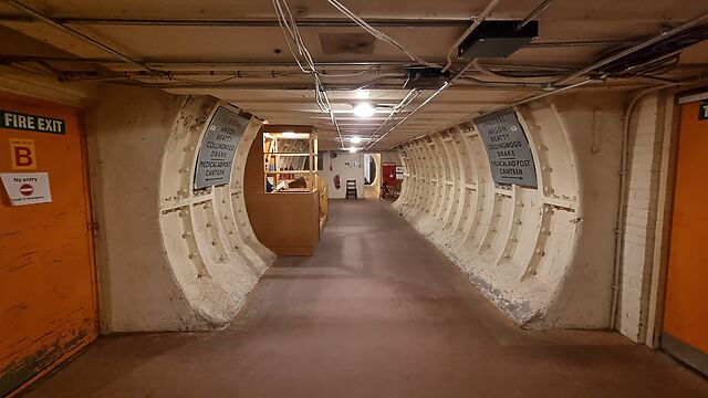
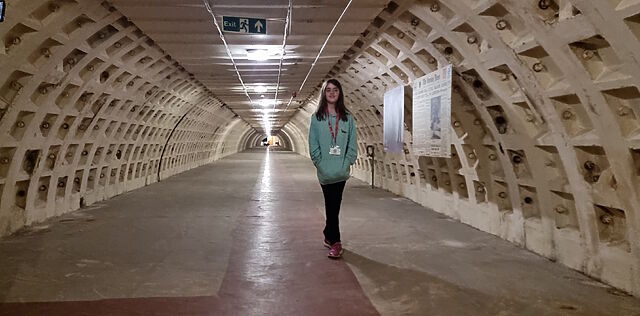
At the weekend, JTA and I – along with our eldest child – explored the Clapham South Deep Shelter as part of one of Hidden London‘s
underground tours, and it was pretty great!
Anybody else get Fallout vibes from this place?
I’ve done a couple of bits of exploration of subterranean London before: in the service tunnels around Euston, and into the abandoned station on the Aldwych branch line. But I was especially impressed by the care and attention that had gone into making this
particular tour fun and engaging.
Had this deep shelter gained a second life as a new tube station, as was originally hoped, this staircase would have connected it to the Northern Line platforms. Instead, it ends at a
brick wall.
The site itself is deep: trains on the Northern Line – already one of the deepest lines on the London Underground – can be heard passing above you, and any
noise from street level is completely gone (even the sounds of bombing couldn’t be heard down here, WWII residents reported). It’s also huge: long interconnected tunnels
provided space for 8,000 beds, plus canteens, offices, toilets, medical bays, and other supporting architecture.
Significant parts of the bunker contain original furniture, including the metal-frames triple-bunk-beds (some of which show signs of being temporarily repurposed as archival storage
shelves). But other bits have been restored to make them feel contemporaneous with the era of its construction.
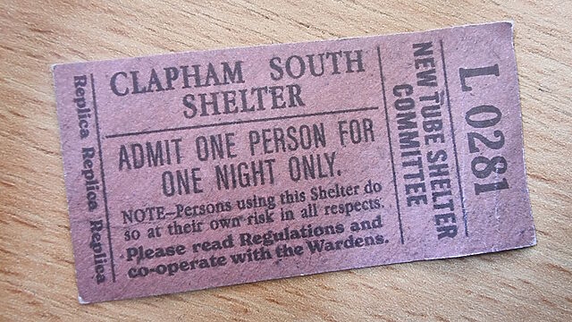
To extend the immersion of the theme even further, there’s a “warden” on-site who – after your 179-step descent – welcomes you and checks your (replica) night admission ticket,
identifying which bed’s bed assigned to you. The warden accompanies your group around, staying in-character as you step through different eras of the history of the place! By the time
you get to the interpretative space about the final days of its use for human habitation – as a budget hotel for the “Festival of Britain” national exhibition in 1951 – he speaks fondly
of his time as its warden here and wonders about what will become of the place.
The long, long double-helix staircases that brought us deep into the earth represented only a fraction of the distance we walked on the tour, through these long networks of tunnels.
All of which is to say that this was a highly-enjoyable opportunity to explore yet another hidden place sprawling beneath London. The Hidden London folks continue to impress.
I’m glad I’ve got a bed of my own in a house of my own that’s not being bombed by the Luftwaffe, actually, thanks.
![Stylish (for circa 2000) webpage for HoTMetaL Pro 6.0, advertising its 'unrivaled [sic] editing, site management and publishing tools'.](https://bcdn.danq.me/_q23u/2025/08/hotmetal-pro-6-640x396.jpg)