As a semi-regular at Fairport’s Cropredy Convention who likes to get up earlier then the others I share my tent with, I’ve done my fair share of early morning geocaching in this neck of
the woods.
Of course: over the years this practice has exhausted most of tree caches local to Cropredy and my morning walks have begun to take me further and further afield. But this is certainly
the first time I’ve walked to the next county in search of a cache!
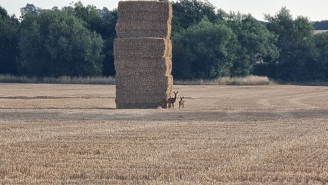
Coming across the fields from Williamscot via Prescote Farm treated me to gorgeous rolling hills free fields of freshly-harvested corn getting picked at by families of deer, while the
red kites above went looking for their breakfasts.
The final hill up to the GZ required a bit of a push for my legs which were dancing until late last night, but soon I was close and the cache was quickly found in the second place I
looked.
My family and I have made a tradition of our regular attendance of Fairport’s Cropredy Convention. There I – being the earliest riser of us – have in turn made a tradition of getting up
early to find a nearby geocache on any morning that I’m up before the kids.
This practice has already eliminated all of the caches in Cropredy itself, and so now my morning walks take me further afield. This morning I opted to follow the footpath over the
fields to Great Bourton to investigate the two multicaches commencing in the churchyard.
Having determined the coordinates for both and (unsuccessfully) attempting the other cache first, I was optimistic for a smiley face here. The GZ was easy to find – I’d stopped here to
check my map on the way out! – and I was soon searching in earnest.
In the low-angled light of the morning sun, the shade of the thick leafy canopy made for challenging conditions, so I flicked my torch on and pointed it in the direction of the host
object… and there, clear as day despite its camouflage, was the cache. Easy as pie! SL.
I was briefly tempted to re-try the cache I failed to find earlier, under the assumption that the container would look similar to this and the same technique might bear fruit. But I
didn’t feel like doubling back twice more while my stomach was rumbling, so I carried on towards Cropredy to see whether any others if my party were yet ready for some grub.
My family and I have made a tradition of our regular attendance of Fairport’s Cropredy Convention. There I – being the earliest riser of us – have in turn made a tradition of getting up
early to find a nearby geocache on any morning that I’m up before the kids.
This practice has already eliminated all of the caches in Cropredy itself, and so now my morning walks take me further afield. This morning I opted to follow the footpath over the
fields to Great Bourton to investigate the two multicaches commencing in the churchyard.
Solving for both was easy enough, and I opted to seek this one first, given that the other could become part of my route back to my tent. As others have observed, finding the right
footpath was slightly tricky: it looks a bit like a communal driveway, to begin with… and then, for the moment at least, looks as though it might become a building site!
But I pressed on towards the target coordinates and soon spotted a likely host. I searched for a bit without luck, then hit up the hint: looks like I need to go deeper, I figured, and
pushed into the foliage.
But after 20 minutes or so of searching all around the conceivable spots, I was still struggling. Plus I’d narrowly avoided kneeling in something truly gross and couldn’t face another
round of crawling about under a hedge. And further, I realised I’d soon need some breakfast so I gave up on this one and made a move for the second. Maybe another year!
“For years, starting in the late ‘70s, I was taking pictures of hitchhikers. A hitchhiker is someone you may know for an hour, or a day, or, every so often, a little longer, yet,
when you leave them, they’re gone. If I took a picture, I reasoned, I’d have a memory. I kept a small portfolio of photos in the car to help explain why I wanted to take their
picture. This helped a lot. It also led me to look for hitchhikers, so that I could get more pictures.
“I almost always had a camera… I finally settled on the Olympus XA – a wonderful little pocket camera. (I’ve taken a picture of the moon rising with this camera.) One time I asked a
chap if I could take a photo, and he said, “You took my picture a few years ago.” I showed him the album and he picked himself out. “That’s me,” he said, pointing…”
…
Not that hitch-hiking is remotely as much a thing today as it was 50 years ago, but even if it were then it wouldn’t be so revolutionary to, say, take a photo of everybody you give a
ride to. We’re all carrying cameras all the time, and the price of taking a snap is basically nothing.
But for Doug Biggert, who died in 2023, began doing this with an analogue camera as he drove around California from 1973 onwards? That’s quite something. Little wonder he had
to explain his project to his passengers (helped, later on, by carrying a copy of the photo album he’d collected so-far that he could show them).
A really interesting gallery with a similarly-compelling story. Also: man – look at the wear-and-tear on his VW Bug!
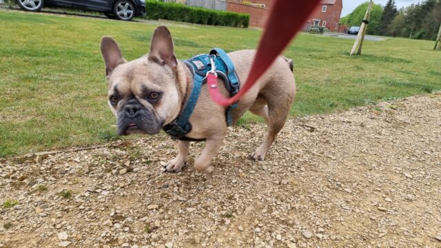
Saw GCB61ZC “Mossy” appear yesterday, but I’d already had an Easter Sunday beer or two and couldn’t drive out here… in fact, I
realised, I probably wasn’t in a state to cycle out here either and so I resolved that I’d come out the following morning – that is, today – by car and give the dog a walk while finding
GL1E5FYX0 and its year-older sibling GCAR5HV “Ivy”.
But early this morning the dog had been poorly and was still needing to relieve herself with little to no notice, so I didn’t want to risk putting her in the car! Though… I did want to
keep her outdoors! It was time for a change in plan: instead of driving to near the cache then taking a walk… we’d attempt the whole thing on foot, perhaps taking the opportunity to
explore some of the back footpaths that we’d not yet had a chance to try. We’d now missed
our chance for the FTF at “Mossy”, but we could still enjoy a walk (and hopefully give the dog a chance to feel better).
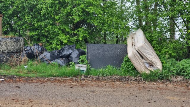
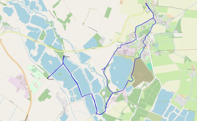
We cut through fields at Sutton, past The Fox and Blackditch Farm, to brush against the side of Lakeside Industrial Estate and head down Dix Pit. After a brief pause to report fly
tipping at 51.745311, -1.412871 (why would anybody fly tip literally just down the road from the recycling centre? it boggles my mind), we decided to duck off the road and take the
parallel public footpath for a bit (OSM Way #204829432, trailhead 51.742330, -1.416563).
To our surprise, the public footpath was fenced off. I thought we might instead be able to take the track to the West and intersect with the nearby bridleway (OSM Way #1129092587) but it was marked as private, so we continued down Dix Pit. How DOES one get to that bridleway, I wondered? Just
out of curiosity we tried to join it via the footpath (OSM Way #1129092588) at 51.737047, -1.412766, but it, too, lacked a
usable gate (and looked severely overgrown!), although the public footpath signs within the mess were still visible. I suspect that this public footpath has been long neglected by the
landowner and is quickly becoming lost to the world.
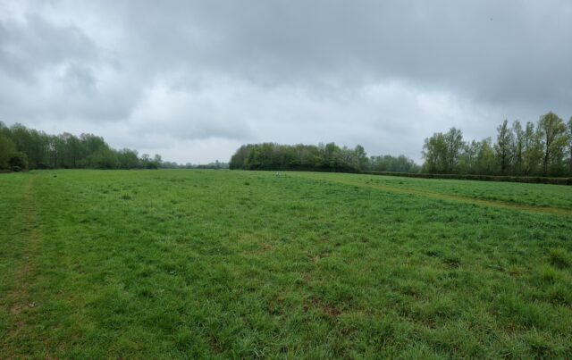
Instead, then, we passed Cutmill Farm and took the footpath through the woods that straddle the boundary line between Stanton Harcourt and Standlake, crossing the Windrush at a bridge
that seemed to serve as the meeting point for a great multitude of dog walkers. My geopup, who’s not always the friendliest with new dogs, enjoyed greeting a few of them while warily
watching the others.
We looped around Oxlease Lake in a clockwise direction, crossed Standlake Brook (the dog was very keen to get a drink of water, and in trying to do so made herself exceptionally muddy),
and began working our way up the long driveway past the swimmers and anglers and sailors assembling and preparing for their bank holiday activities. I recalled that I’d been up this way about a year ago to find GCAQJN1 “Hardwick park 1”: I got the FTF on that, but it proved to be a short-lived
cache, getting retired only three or four months later when park owners cut back the trees that had been its host. But I’d actually been here much earlier, too – over a decade ago –
long before I moved to the local area, to find the much-more long-lived GC1TPFY “Constellations 4”. Strange to hunt for
caches in places that I’ve walked past at least twice before, before those caches were hidden!
First up was “Mossy” (GCB61ZC). The dog – who was by now feeling herself again and happy to lead the way – struggled with the narrow kissing-gate to get onto the trail (she’s not so
bright and doesn’t understand that she needs to make room for me to join her before I can open the gate) but soon we were on the path. The hiding place leapt out at me and soon the
cache was in hand, the log signed (right behind Mad H@ter, whose Leafield series I was just attempting five days ago), and the cache returned to its hiding spot beneath its excellent
camoflage. I hope the container survives the winter rains!
Second was “Ivy” (GCAR5HV): a brief walk through the holiday park away (via a glance at the watersports centre, which by the looks of things have paddleboards for rent: I first tried
paddleboarding on the sea and figure it might be easier on a lake, so perhaps I’ll find an excuse to come down here and have a go at some point). The host was easy to find, but it took
some searching to put my hand on the container because I started at the “wrong” side. It looks like it’s had (unlogged?) maintenance done since BusyLittleGeo’s visit last week: the
cache was in perfect condition and the logbook was empty.
Now it was time to return home and give this happy (but mucky) dog a bath. We retraced our steps until Dix Pit, but then cut through the Devils’ Quoits and out through Hayfield Green to
return to Stanton Harcourt, and from there picked our way back through the fields at Sutton to return home.
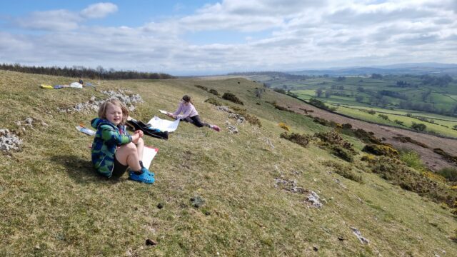
Brought the kids up Knipe Scar with limited and challenging art materials (huge sheets of paper and thick marker pens) for a lesson in drawing what a landscape makes you feel, rather
than focusing on what you can actually see.
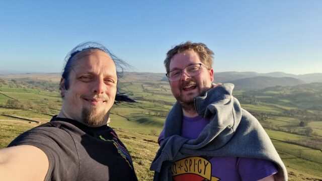
A swift uphill scramble for my friend and fellow volunteer John and I, before dinner. We’re staying in a nearby farmhouse for a week of volunteer work, writing software to help charities. Beautiful view from the summit this evening! SL, TNLN, TFTC!
On Wednesday, Vodafone
announced that they’d made the first ever satellite video call from a stock mobile phone in an area with no terrestrial signal. They used a mountain in Wales for their experiment.
It reminded me of an experiment of my own, way back in around 1999, which I probably should have made a bigger deal of. I believe that I was the first person to ever send an email from
the top of Yr Wyddfa/Snowdon.
Nowadays, that’s an easy thing to do. You pull your phone out and send it. But back then, I needed to use a Psion 5mx palmtop, communicating over an infared link using a custom driver
(if you ever wondered why I know my AT-commands by heart… well, this isn’t exactly why, but it’s a better story than the truth) to a Nokia 7110 (fortunately it was cloudy enough to not
interfere with the 9,600 baud IrDA connection while I positioned the devices atop the trig point), which engaged a GSM 2G connection, over which I was able to send an email to myself,
cc:’d to a few friends.
It’s not an exciting story. It’s not even much of a claim to fame. But there you have it: I was (probably) the first person to send an email from the summit of Yr Wyddfa. (If you beat
me to it, let me know!)
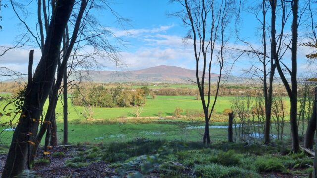
Gorgeous view of Slievenamon towering over Kilsheelan, Co. Tipperary, Ireland, as seen from Gurteen Wood, where my mother and I are just on our way back from our successful expedition
to the 2024-11-24 52 -7 geohashpoint.
On our first day‘s walking along the
Thames Path, Robin and I had trouble finding any evidence of water for some time. On our second day, we did not have this problem.
After weeks of sustained rain, the fields we walked over as we left Cricklade behind were extremely soggy. On our way out of town we passed Cricklade Millennium Wood, I took a
picture for the purpose of mocking it for being very small but later discovered it’s too small to appear on Google Maps and became oddly defensive of it – it’s trying, damn it, we
should at least acknowledge its existence.
…
Ruth and her brother Robin (of Challenge Robin/Challenge Robin II fame on this blog, among manyothercrazyadventures) have taken it upon themselves to walk the entirety of the Thames Path from the source of the river (or rather, one of
the many symbolic sources) to the sea, over the course of a series of separate one-day walks. I’ve mostly been acting as backup-driver so far, but I might join them for a leg or two
later on.
In any case, Ruth’s used it as a welcome excuse to dust off her blog and write about the experience, and it’s fun and delightful and you should follow along and give her a digital
cheer. The first part is here; the second part landed
yesterday.
Hiking vlogger Dave shares his expedition around the Snowdon Horseshoe back in March. It’s a fantastic ridge walk that I’ve taken a few times myself. But on this particular expedition,
hampered by strong winds and thick cloud cover, a serious accident (very similar to the one that killed my father) occurred. Because Dave
was wearing his GoPro we’ve got amazing first-hand footage of the work he and the other climbers on the hill that day did to stabilise the casualty until mountain rescue could come and
assist. The whole thing’s pretty epic.
Speaking of which, did you see the jet-suits that are being tested by the Great North Air Ambulance Service? That’d
have made getting to my dad faster (though possibly not to any benefit)! Still: immensely cool idea to have jet-propelled paramedics zipping up Lake District slopes; I love it.
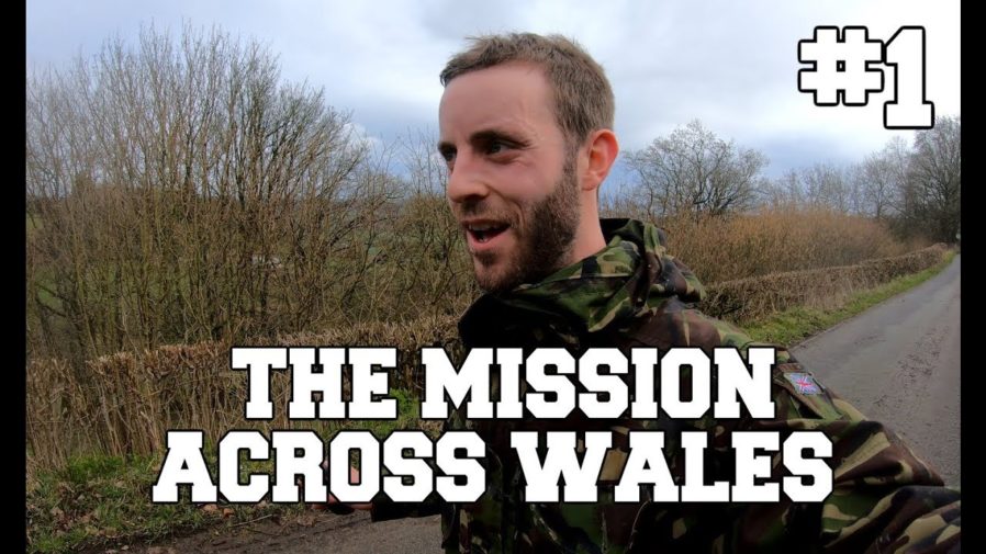
Truly in the style and spirit of Challenge Robin / Challenge Robin II, this sweary idiot decides
to try to cross Wales in as close as possible to a completely straight line, cutting through dense woods, farms, rivers, hedgerows and back gardens. Cut up by barbed wire, stung by
nettles, swimming through freezing rivers, and chased by farmers, it makes for gruelling, hilarious watching. Link is to the four-hour playlist; put it on in the background.
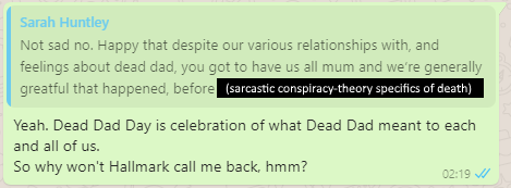
I’m not sure that I process death in the same way that “normal” people do. I blame my family.
My sisters and I have wished one another a “Happy Dead Dad Day” every 19 February since his death.
When my grandmother died in 2006 I was just in the process of packing up the car with Claire to
try to get up to visit her before the inevitable happened. I received the phone call to advise me that she’d passed, and – ten emotional
minutes later – Claire told me that she’d “never seen anybody go through the five stages of grief as fast as that
before”. Apparently I was a textbook example of the Kübler-Ross model, only at speed. Perhaps I should volunteer to stand in front of introductory psychology classes and feel things, or
something.
I guess there isn’t actually a market for Happy Dead Dad Day greetings cards?
Since my dad’s death seven years ago, I’ve marked Dead Dad Day every 19 February a way that’s definitely “mine”: with a pint or three of Guinness
(which my dad enjoyed… except if there were a cheaper Irish stout on draught because he never quite shook off his working-class roots) and some outdoors and ideally a hill, although
Oxfordshire makes the latter a little difficult. On the second anniversary of my dad’s death, I commemorated his love of setting out and checking the map later by making
my first geohashing expedition: it seemed appropriate that even without him, I could make a journey without either of us
being sure of either the route… or the destination.
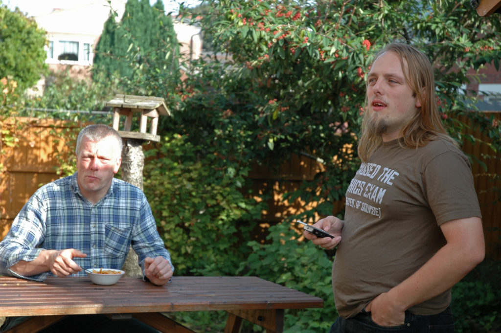
Eating cornflakes together in the garden was a tradition of my dad and I’s since at least 23 years before this photo was taken.
As I implied at his funeral, I’ve always been far more-interested in celebrating life than
mourning death (that might be why I’m not always the best at supporting those in grief). I’m not saying that it isn’t sad
that he went before his time: it is. What’s worst, I think, is when I remember how close-but-not-quite he came to getting to meet his grandchildren… who’d have doubtless called him
“Grandpeter”.
We all get to live, and we’re all going to die, and I’d honestly be delighted if I thought that people might remember me with the same kind of smile (and just occasionally tear) that
finds my face every Dead Dad Day.