Nineteen years ago, the British government passed one of its periodic laws to manage how people move through the countryside. The Countryside and Rights of Way Act created a new
“right to roam” on common land, opening up three million acres of mountains and moor, heath and down, to cyclists, climbers, and dog walkers. It also set an ambitious goal: to record
every public path crisscrossing England and Wales by January 1, 2026. The British Isles have been walked for a long time. They have been mapped, and mapped again, for centuries. But
that does not mean that everything adds up, or makes sense. Between them, England and Wales have around a hundred and forty thousand miles of footpaths, of which around ten per cent
are impassable at any time, with another ten thousand miles that are thought to have dropped off maps or otherwise misplaced. Finding them all again is like reconstructing the roots
of a tree. In 2004, a government project, named Discovering Lost Ways, was given a fifteen-million-pound budget to solve the problem. It ended four years later, overwhelmed. “Lost
Footpaths to Stay Lost,” the Daily Telegraph reported. Since then, despite the apparent impossibility of the task, the 2026 cutoff has remained on the statute books,
leaving the job of finding and logging the nation’s forgotten paths to walkers, horse people, and other obsessives who can’t abide the muddled situation.
A couple of days into the New Year, with the deadline now only seven years off, I met Bob Fraser, a retired highway engineer, in a parking lot a few miles outside Truro, in Cornwall,
in the far west of England. Fraser grew up in Cornwall and returned about thirty years ago, which is when he noticed that many footpaths were inaccessible or ended for no reason. “I
suppose that got me interested in trying to get the problem sorted out,” he said. Since he retired, seven years ago, Fraser has been researching and walking more or less full time; in
the past three years, he has applied to reinstate sixteen lost paths.
As well additional land around our familiar coastlines, the lower sea level reveals a low lying 9,000 square mile landmass called Doggerland – named after Dogger Bank, the large
sandbank which currently sits in a shallow area of the North Sea off the east coast of England (dogger being an old Dutch word for fishing boat).
Doggerland had a rich landscape of hills, rivers and lakes and a coastline comprising lagoons, marshes and beaches. It had woodlands of oak, elm, birch, willow, alder, hazel and
pine. It was home to horses, aurochs, deer, elks and wild pigs. Waterfowl, otters and beavers abounded in wetland areas and the seas, lakes and rivers teemed with
fish. It was probably the richest hunting and fishing ground in Europe at the time and had an important influence on the course of prehistory in northwestern Europe as maritime
and river-based societies adapted to this environment.
…
I love a bit of alternative history fiction, and this is a big one, going all the way back to prehistoric times. What if the period of global warming that took place thousands
of years ago, “sinking” Doggerland and separating the formerly-connected British Isles from one another and from the European mainland? The potential impact is massive, affecting
geography, history, and politics indefinitely, and it’s fun to think – and read – about.
There’s been a lot of talk about the missionary killed by the natives of North Sentinel Island. They’re probably so aggressive because of this weirdo, Maurice Vidal Portman. So
here’s a big thread about this creep and some facts from my decade-long obsession with the island.
The Sentinelese are often described as “uncontacted,” but this not strictly true. They had a very significant contact in 1880 with Commander Portman.
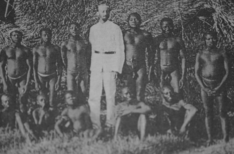
Portman, the black sheep third son of some minor noble, was assigned by the English Royal Navy to administer and pacify the Andaman Islands, a job he pursued from 1880-1900 with
the full measure of his own perversity.
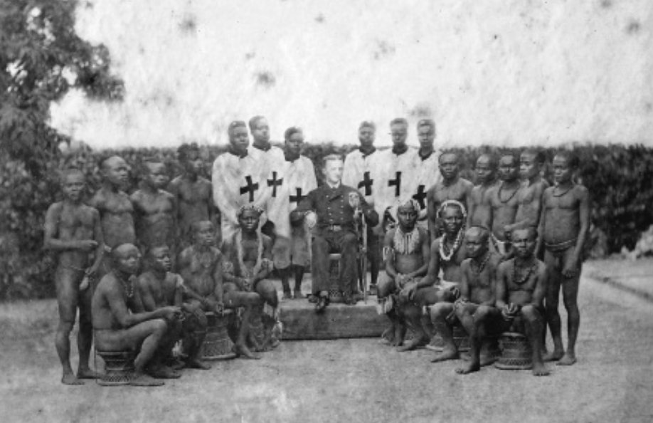
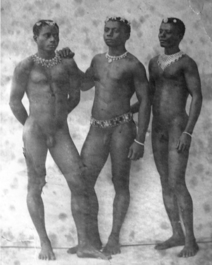
Portman was erotically obsessed with the Andamanese, and he indulged his passion for photography by kidnapping members of various tribes and posing them in mock-Greek homoerotic
compositions.
During his 20 years in a sexualized heart of darkness, Portman measured and cataloged every inch of his prisoner’s bodies, with an obsessive focus on genitals.
Just imagine being a Neolithic person spending a few weeks in this guy’s rotating menagerie.
Portman spent most of his time in the greater Andaman Islands, but in 1880, he landed on North Sentinel. The natives fled, and his party ventured inland to find a settlement
which had been abandoned in haste.
But they located an elderly couple and a few children they were able to abduct. The couple quickly died, likely from ailments to which they had no immunity.
The children spent a few weeks with Portman doing god knows what, after which he returned them to the island. Portman returned on a couple occasions, but the Sentinelese hid
from him each time.
The story related by the children was certainly passed down among the 100 or so inhabitants of the island, and even today, Portman’s fatal kidnapping is just beyond a human
lifetime.
So when the Indian government attempted contact with anthropologists in the 1960s and 70s, the Sentinelese were understandably hostile to outsiders. The Indian government soon
gave up.
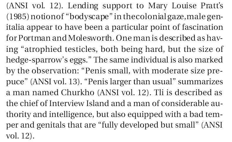
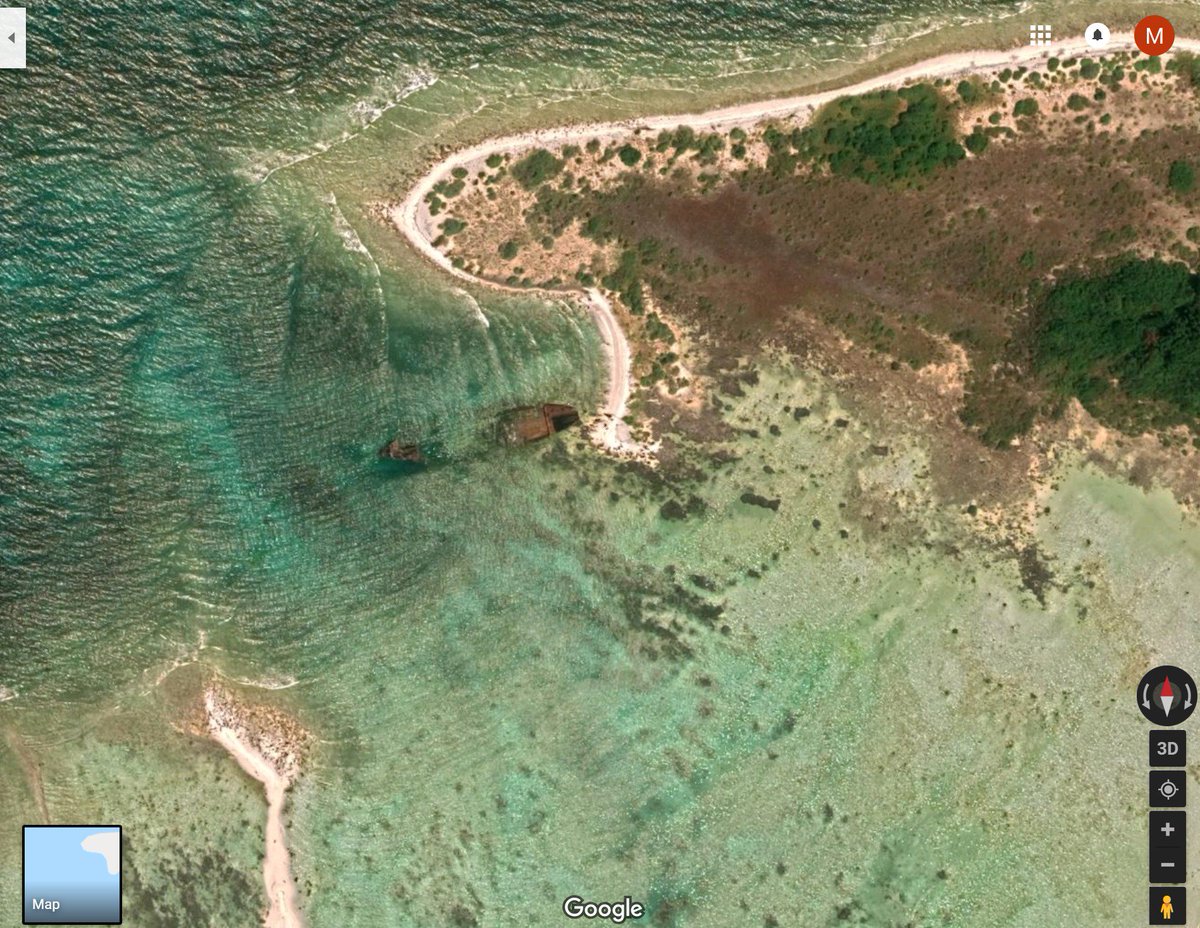
In 1981, a cargo ship named The Primrose ran aground on the coral reef surrounding North Sentinel. The crew radioed for assistance and settled in for a long wait. But in the
morning they saw 50 men with bows on the beach, building makeshift boats.
The crew called for an emergency airlift and were evacuated, and not a moment too soon. Rough waves had thwarted the Sentinelese in their attempts to board, but the weather was
clearing.
The ship and its cargo were left at the island, awaiting discovery by Neolithic eyes. Today you can still see the gutted remains on The Primrose on Google Earth.
Imagine climbing on board that ship. A completely alien vessel filled with alien things. Imagine seeing simple machines for the first time. A hinge. A latch. A wheel. Things
that would instantly make sense in a satisfying way. Others would be so incomprehensible to avoid notice.
I have never been able to find out what cargo was on The Primrose in all my years of reading. There was about 100 tons of some sort of consumer product on board, and I’m curious
what it was. But even absent the cargo, think about all the things that must have been on that ship.
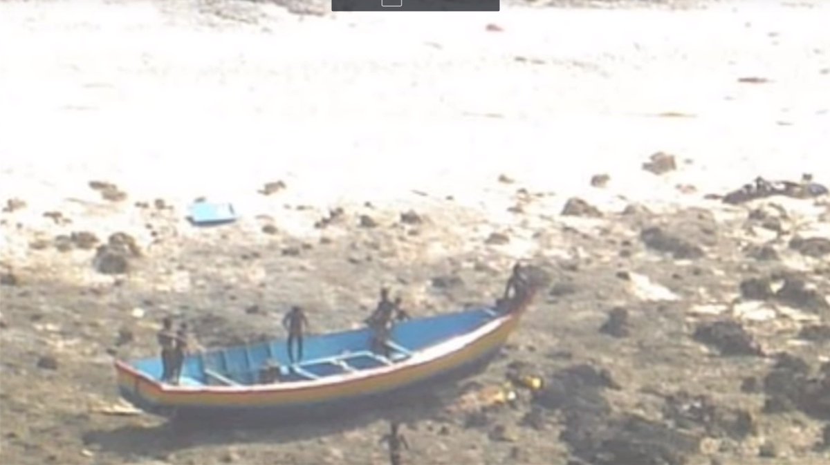
In the 1990s, when anthropologists returned to the island to make new attempts at contact, they were met with a different attitude. Not friendly, exactly. But they were willing
to accept gifts. Many would wade into the water with smiles to accept coconuts.
Here is a video of one of those encounters:
And in those videos, you can see that these pre-iron age people now had metal weapons, like the knife carried by this man. They had scavenged metal from the Primrose and
cold-forged it into tools.
After collecting gifts for a few minutes, a few members of the tribe would approach and make menacing gestures, signaling that it was time for the outsiders to leave. They have
never lost their desire for isolation, despite the gifts.
And they remained consistent in their intolerance against intruders. In 2006, two fishermen were killed after drifting into the island when their anchor detached while they were
sleeping.
The Sentinelese are lucky they were so effective at preventing contact. The neighboring Jawara weren’t so fortunate. The tribe went from 9,000 to a couple hundred from lack of
genetic immunity and only forestalled annihilation due to aggressive segregation. Their future is bleak.
Yet on North Sentinel, they’ve maintained a small community for 60,000 years which is by all indications happy. There is no way to integrate them into the modern world without
wiping out nearly every member of their tribe.
And their aggressiveness is not the mark of savagery. It just that their conception of outsiders is mostly framed by some foot-faced English pervert who murdered some old people
and did weird things to their kids. So let’s do them a favor and leave them alone.
The history of the organisation known as OS is not merely that of a group of earnest blokes with a penchant for triangulation and an ever-present soundtrack of rustling cagoules.
From its roots in military strategy to its current incarnation as producer of the rambler’s navigational aid, the government-owned company has been checking and rechecking all 243,241 sq km (93,916 sq miles) of Great Britain for
227 years. Here are some of the more peculiar elements in the past of the famous map-makers.
This is a story of a country that journeyed from rags to riches and back to rags. It’s a cautionary tale of what happens when a nation exploits its natural resources at the expense of
people’s lives…
When Portugese explorers landed in the area of South America we now call Brazil in the year 1500, they discovered the caesalpinia echinata tree
growing there. They noticed that this tree had a similar red-coloured wood as the related Sappanwood (caesalpinia sappan) tree, native to Asia, and
that a similarly-useful red dye could be extracted from this wood, so they gave the newly-discovered species the same name that they used to describe its Asian relative: pau-brasil. Pau means ‘wood’ and brasil probably derives from brasa, the Portugese word for “ember”, so pau-brasil best translates as “emberwood”. The colour of its wood was clearly known
to the natives, too, who called it ibirapitanga – Tupi for, literally, “red wood”.
At this time, the Portugese called the area Ilha de Vera Cruz (“Island of the True Cross”), after the holy day on which the Portugese captain Pedro
Álvares Cabral landed there. On his return trip, he discovered that Brazil was not an island but connected to a much larger continent, and renamed it Terra de Santa Cruz (“Land of the Holy Cross”). Another common name in the years that followed was come up with by Italian merchants who met with members of
Cabral’s crew – Terra di Papaga (“Land of Parrots”) – which I personally think would have been an awesome name for the country.
Anyway: a group of merchants moved over to the new Portugese colony in the first decade of the 16th century in order to harvest the wood of the caesalpinia echinata trees. You see, it turned out to be even better as a source of red dye than the previously commercially-exploited caesalpinia sappan. Prior to this time, this particular kind of red dye was very popular in Europe, and could only be imported via India (which was very
expensive). By being able to produce an even higher-quality dye at lower cost made the colonial Portugese merchants very rich.
The Portugese had a habit at the time of coming to name their colonies after the commercial product they exploited there: see, for example, the Ilha da
Madeira, or “Maderia Island”, which literally translates as “Island of Wood”. This habit continued in their new colony too: the São Francisco River (the longest river whose
entire length is in Brazil and the fourth-longest in South America) was labelled on a 1502 map as Rio D Brasil (“River of Brasil”), which was clearly
a reference to the great quantity of pau-brasil trees that could be found there. By 1509, the general term for the land had become terra do Brasil daleem
do mar Ociano (“land of Brazil beyond the Ocean sea”), and in 1516 the name received official recognition with the appointment by the Portugese king of the first “governor of
Brasil”.
A clue to this history appears today in the name of inhabitants of Brazil, who call themselves Brasileiro: the -eiro suffix means ‘worker’, similar to putting -er on the end of an English word to get e.g. baker or hunter – clearly this
refers to the use of the Tupi tribes by the Portugese as woodcutters during their colonial era (the usual Portugese suffix for ‘person who lives in’ is not -eiro but -ano).
So there you have it: the nation of Brazil is almost certainly named after a type of tree, and is the only nation in the world for which this is the case. Hope you enjoyed your
history lesson, and that you continue to enjoy your stay in /r/MegaLoungeBrazil!
tl;dr: 16th century Portugese colonists and subsequent merchants named Brazil afterpau-brazil, the name they gave to a type of tree that grew there, which was in turn named after a related Asian tree
of the same name. When this new tree became economically valuable, they began referring to the whole area by that name, as was Portugese tradition at the time.
While you’re tucking in to your turkey tomorrow and the jokes and puzzles in your crackers are failing to impress, here’s a little riddle to share with your dinner guests:
Which is the odd-one out: gypsies, turkeys, french fries, or the Kings of Leon?
If you answer “turkey, because it’s the only one that’s a bird,” then you’re somewhat missing the point.
In order to save you from “accidentally” reading too far and spoling the answer for yourself, here’s a picture of a kitten to act as filler:
Aww.
Want a hint? This is a question about geography. Specifically, it’s a question about assumptionsabout geography. Have
another think: the kittens will wait.
Interestingly, this Persian cat could easily be another candidate for the odd-one-out.
Okay. Let’s have a look at each of the candidates, shall we? And learn a little history as we go along:
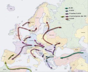
Gypsies
The Romami are an ethnic group of traditionally-nomadic people, originating
from Northern India and dispersing across Europe (and further) over the last millenium and a half. They brought with them some interesting anthropological artefacts of their culture,
such as aspects of the Indian caste system and languages (it’s through linguistic similarities that we’ve been best-able to trace their multi-generational travels, as written records of
their movements are scarce and incomplete), coupled with traditions related to a nomadic life. These traditions include strict rules about hygiene, designed to keep a travelling
population free of disease, which helped to keep them safe during the European plagues of the 13th and 14th centuries.
The migration of the Romanies. The arrows show that they stopped in France for some French Fries before continuing to Britain.
Unfortunately for them, when the native populations of Western European countries saw that these travellers – who already had a reputation as outsiders – seemed to be immune to the
diseases that were afflicting the rest of the population, their status in society rapidly degraded, and they were considered to be witches or devil-worshippers. This animosity made
people unwilling to trade with them, which forced many of them into criminal activity, which only served to isolate them further. Eventually, here in the UK, laws were passed to attempt
to deport them, and these laws help us to see the origins of the term gypsy, which by then had become commonplace.
Consider, for example, the Egyptians Act 1530, which uses the word
“Egyptian” to describe these people. The Middle English word for Egypian was gypcian, from which the word gypsy or gipsy was a
contraction. The word “gypsy” comes from a mistaken belief by 16th Century Western Europeans that the Romani who were entering their countries had emigrated from Egypt. We’ll get back
to that.
Turkeys
When Europeans began to colonise the Americas, from the 15th Century onwards, they discovered an array of new plants and animals previously unseen by European eyes, and this ultimately
lead to a dramatic diversification of the diets of Europeans back home. Green beans, cocoa beans, maize (sweetcorn), chillis, marrows, pumpkins, potatoes, tomatoes, buffalo, jaguars,
and vanilla pods: things that are so well-understood in Britain now that it’s hard to imagine that there was a time that they were completely alien here.
Gobblegobblegobblegobble.
Still thinking that the Americas could be a part of East Asia, the explorers and colonists didn’t recognise turkeys as being a distinct species, and categorised them as being a kind of
guineafowl. They soon realised that they made for pretty good eating, and started sending them back to their home countries. Many of the turkeys sent back to Central Europe arrived via
Turkey, and so English-speaking countries started calling them Turkey fowl, eventually just shortened to turkey. In actual fact, most of the turkeys reaching
Britain probably came directly to Britain, or possibly via France, Portugal, or Spain, and so the name “turkey” is completely ridiculous.
Fun fact: in Turkey, turkeys are called hindi, which means Indian, because many of the traders importing turkeys were Indians (the French, Polish, Russians, and Ukranians
also use words that imply an Indian origin). In Hindi, they’re called peru, after the region and later country of Peru, which also isn’t where they’re from (they’re native
only to North America), but the Portugese – who helped to colonise Peru also call them that. And in Scottish Gaelic, they’re called cearc frangach – “French chicken”!
The turkey is a seriously georgraphically-confused bird.
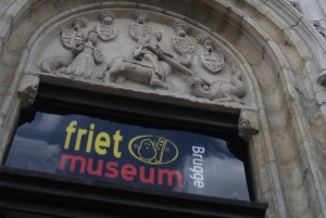
French Fries
As I’m sure that everybody knows by now, “French” fries probably originated in either Belgium or in the Spanish Netherlands (now part of Belgium), although some French sources claim an
earlier heritage. We don’t know how they were first invented, but the popularly-told tale of Meuse Valley fishing communities making up for not having enough fish by deep-frying pieces of potato, cut into the shape of fish, is
almost certainly false: a peasant region would be extremely unlikely to have access to the large quantities of fat required to fry potatoes in this way.
They may find it hard to prove that they invented fries, but the Belgians certainly hold the claim to the world’s only museum dedicated to the food.
So why do we – with the exception of some confusingly patriotic Americans – call them French fries. It’s hard to say for
certain, but based on when the food became widely-known in the anglophonic world, the most-likely explanation comes from the First World War. When British and, later, American soldier
landed in Belgium, they’ll have had the opportunity to taste these (now culturally-universal) treats for the first time. At that time, though, the official language of the Belgian army
(and the most-popularly spoken language amongst Belgian citizens) was French. The British and American soldiers thus came to call them “French fries”.
The Kings of Leon
For a thousand years the Kingdom of Leon represented a significant part of what would not be considered Spain and/or Portugal, founded by Christian kings who’d recaptured the Northern
half of the Iberian Peninsula from the Moors during the Reconquista (short
version for those whose history lessons didn’t go in this direction: what the crusades were against the Ottomans, the Reconquista was against the Moors). The Kingdom of Leon
remained until its power was gradually completely absorbed into that of the Kingdom of Spain. Leon still exists as a historic administrative region in Spain, similar to the counties of
the British Isles, and even has its own minority language (the majority language, Spanish, would historically have been known as Castilian – the traditional language of the neighbouring
Castillian Kingdom).
Leon, sandwiched between the other kingdoms of the 13th century Iberian Peninsula.
The band, however, isn’t from Leon but is from Nashville, Tennessee. They’ve got nothing linking them to actual Leon, or Spain at all, as far as I can tell, except for their name – not
unlike gypsies and Egypt, turkeys and Turkey, and French fries and France. The Kings of Leon, a band of brothers, took the inspiration for their name from the first name of their father
and their grandfather: Leon.
The Odd One Out
The Kings of Leon are the odd one out, because while all four have names which imply that they’re from somewhere that they’re not, the inventors of
the name “The Kings of Leon” were the only ones who knew that the implication was correct.
The people who first started calling gypsies “gypsies” genuinely believed that they came from Egypt. The first person to call a turkey a “Turkey fowl” really was under the impression
that it was a bird that had come from, or via, Turkey. And whoever first started spreading the word about the tasty Belgian food they’d discovered while serving overseas really thought
that they were a French invention. But the Kings of Leon always knew that they weren’t from Leon (and, presumably, that they weren’t kings).
And as for you? Your sex is on fire. Well, either that or it’s your turkey. You oughta go get it out of the oven if it’s the latter, or – if it’s the former – see if you can get some
cream for that. And have a Merry Christmas.
The Sentinelese (also called the Sentineli or North Sentinel Islanders) are the indigenous people of North Sentinel Island in the Andaman Islands of India. One of the
Andamanese people, they resist contact with the outside world. They are one of the uncontacted peoples, although like all of today’s so-called uncontacted people they have a history
of limited contact.
Comparative map showing the distribution of Andamanese tribes in the Andaman Islands – early
1800s versus in 2004. Notably:
(a) Rapid depopulation of the original southeastern Jarawa homeland in the 1789–1793 period
(b) Onge (in blue) and Great Andamanese shrinkage to isolated settlements
(c) Complete Jangil extinction by 1931
(d) Jarawa move to occupy depopulated former west coast homeland of the Great Andamanese, and
(e) Only the Sentinelese zone is somewhat intact
The population is estimated at 40 to 500. In 2001, Census of India officials recorded 21 males and
18 females. This survey was conducted from a distance and may not be accurate for the population which ranges over the 59.67 km2 (14,700 acres) island. The 2011 Census of India recorded 12 males and three females. Any effect from the 2004 Indian Ocean earthquake and resulting tsunami is not known, other than the confirmation obtained that they had survived the immediate aftermath.
Author Heinrich Harrer described one man as being 1.6 metres (5 ft 3 in) tall and
apparently left handed.
Scientists investigating this week’s catastrophic lunchquake in the Dan’s Lunchbox region have released a statement today about the techtonic causes of the disaster.
Analysis of the lunchquake.
“The upheaval event, which reached 5.9 on the Tupperware Scale, was probably caused by overenthusiastic cycling,” explained Dr. Pepper, Professor of Lunchtime Beverages at Tetrapak
University.
“The breadospheres ‘float’ on soft, viscous eggmayolayers. Usually these are stable, but sometimes a lateral shift can result in entire breadosphere plates being displaced underneath
one another.”
This is what happened earlier this week, when a breadospheric shift resulted in catastrophic sinkage in the left-side-of-lunchbox area, eggmayolayer “vents”, and an increase in the
height of Apple Mountain.
No lives were lost during the disaster. However, two jammie dodgers were completely ruined.
Recent emissions in the ring of fire area is unrelated to this recent lunchquake, and are instead believed to be associated with excessive consumption of spicy food at lunchtimes.
Have you come across GeoMidpoint? This web service will help you find the midpoint between any number of geographical
points. They’ve got all kinds of proposed uses for it, like finding a convenient restaurant
that’s equidistant from each of you and your friends, but one of the more frivolous activities you can enjoy using it for is to find your home “centre of gravity”. Put in everywhere
you’ve lived (and, optionally, how long you lived there for, as a weighting factor), and it’ll show you the centre point.
I gave it a go. Here’s where I’m centred.
Dan's centre point (the green 'M' pin).
Okay, you think – it’s not so surprising that the centre point is near Preston: I spent over a decade living there. But here’s the quirk: my addresses weren’t weighted by how long I’d
lived there. All I did is put in everywhere I’d lived for six months or more, and let these places all have equal weight.
Curious, then, that the centre point comes to within a quarter hour’s drive of either of my parents’ houses, in Preston.
I suppose there are some balancing factors, here: places that cancel one another out quite nicely. The Northern bias of Scotland is counteracted by the comparative Southernness of
Aberystwyth, Oxford, and Surrey. The strong Western bias of the many different places I lived in Aberystwyth are invalidated by quite how far East Aberdeen and London are. But still, it
seems to be a quirky coincidence to me that the centre point would be so close to where I did most of my growing up, despite how much I’ve moved around.
New Earth, where we'll be moving later this year
This observation comes only a little while after the other Earthlings and I have
finished signing the paperwork on what is later this year to become our new home, New Earth. It’s still in the Oxford area, but provides us with some nice things that we’re looking
forward to, like more space (something we never seem to have enough of!). And any of you who’ve visited by car will probably appreciate how much more accessible the driveway is…
We’ll be moving this Summer, and in doing so we’ll pull my little green triangle over into Chorley. Better that, I think, than out in the Irish sea, which is where it’d be if I weighted
where I’d lived by the amount of time I’d spent there!
Recently, I learned that the roads in Great Britain are numbered in accordance with a scheme first imagined about ninety years ago, and, as it evolved, these road numbers were grouped into radial zones around London (except for Scotland, whose road
numbering only joined the scheme later). I’d often noticed the “clusters” of similarly-numbered roads (living in Aberystwyth, you soon notice that all the A and B roads start with a 4,
and I soon noticed that the very same A44 that starts in Aberystwyth seems to have followed me to my home here
in Oxford).
Road Numbering Zones of the United Kingdom
Who’d have thought that there was such a plan to it. If you’re aware of any of the many roads which are in the “wrong” zone, you’d be forgiven for not seeing the pattern earlier, though. However, seeing all of this
attempt at adding order to what was a chaotic system for the long period between the Romans leaving and the mid-20th century makes me wonder one thing: are there
“roadspotters”?
There exist trainspotters, who pursue the more-than-a-little-bit-nerdy hobby of traveling around and looking at different locomotives, marking down their numbers in notepads and
crossing them off in reference books. Does the same phenomena exist within road networks?
It turns out that it does; or some close approximation of it does, anyway. One gentleman, for example, writes about “recovering” road signs formerly of the A6144(M), which – until 2006 – was the UK’s only single-carriageway motorway. A site calling
itself The Motorway Archive has a thoroughly-researched article on the construction history of the M74/A74(M) from Glasgow to Carlisle. Another website – and one that I’m embarrassed to
admit that I’d visited on a number of previous occasions – reviews every motorway service
area in Britain. And, perhaps geekiest of all, the Society for All British
and Irish Road Enthusiasts (SABRE) maintains a club, meetups, and a thoroughly-researched wiki of everything you never wanted to know about the roads of the British Isles.
From what started as a quick question about British road numbering, I find myself learning about a hobby that’s perhaps even geekier than trainspotting. Thanks, Internet.
Just when you think you’ve got them figured out (and the application you’re working on is coping correctly with daylight saving time), something comes along and blows your little mind. Like this, for example:
Suppose you’re chilling out in Hawaii on some lazy Sunday. Cocktail in hand, you check your
watch – it’s midday. Midday on Sunday – that means you’ve got a ‘plane to catch: you’re about to fly due South to the research station on Palmyra Atoll, part of the Line Islands. Palmyra Atoll, like Hawaii, is part of the United States, so you don’t even need your passport, but you pause for a moment
to try to work out whether you need to adjust your watch…
A timezone map of the mid-Pacific Ocean, showing the islands in question.
When it’s midday on Sunday in Hawaii, what time is it in Palmyra Atoll (which is at essentially the same longitude)?
It’s midday… on Monday! The Line Islands are uniquely considered to be in the timezone UTC+14:00 (and Hawaii is in UTC-10:00), so despite the fact that the Line Islands are, on the whole, East of the Hawaiian islands, the whole cluster of them are an
entire day ahead of Hawaii. Even those which are managed by the U.S. are closer to New Zealand (chronologically) than they are to any other U.S. terrirory (even though they’re more
distant geographically). It’s no wonder people get confused by things like the International Date Line – Magellan was apparently so confused by the fact that his ship’s log was a day out upon his return from a round-the-world trip that
he wrote a letter to the Pope about
the oddity.
Similarly, when the sun rises on the Line Islands, it marks the beginning of the day after the date that it rises on Hawaii, ten minutes later.
I find this particular quirk even more interesting than the similar one on the Diomede Islands (a pair of islands in the Bering Strait), sometimes called “Tomorrow Island” and “Yesterday Island”. The Diomedes are
clearly separated in an East-West configuration, whereas the Line Islands are clearly to the South (and North) of islands which are still stuck in “yesterday”.
The Diomede Islands
In practice, apparently, the 4 – 20 scientists living at any given time on Palmyra Atoll work at UTC-11:00: only an hour from Hawaii – presumably so that they maximise the period that their work week lines up with that in the rest of the
United States: but this only serves to exaggerate the phenomena: this means that you can hop from, say, Palmyra Atoll to nearby Teraina (population 1,155, about 150 miles away) and have to wind your watch forward by a massive 25 hours (or just one hour, I suppose).
By the time you’re living on a South Pacific island paradise, I suppose these things don’t matter so much.


