This checkin to GC674F4 5L6 45 Charlie's 5th Loop reflects a geocaching.com log entry. See more of Dan's cache logs.
On campus for an exam but running a little early; had time to find this cache (hampered only slightly by the season…!).TFTC!
This checkin to GC674F4 5L6 45 Charlie's 5th Loop reflects a geocaching.com log entry. See more of Dan's cache logs.
On campus for an exam but running a little early; had time to find this cache (hampered only slightly by the season…!).TFTC!
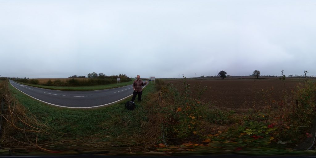
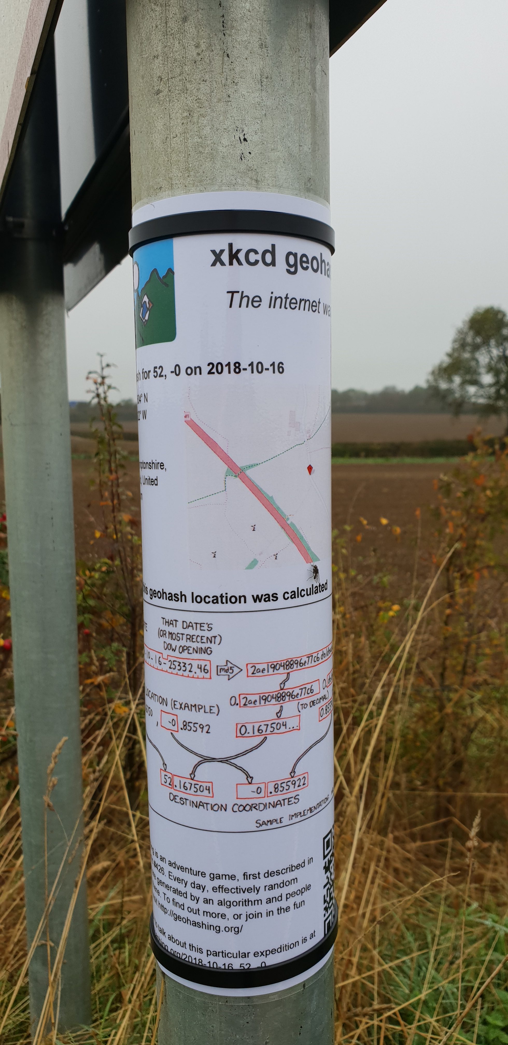
This checkin to geohash 2018-10-16 52 -0 reflects a geohashing expedition. See more of Dan's hash logs.
Alongside a lane that runs through the Quinton Green Business Park, South of the village of Quinton.
I’ve got an exam in Milton Keynes in the afternoon, so it’d be only a minor diversion for me to come and try to visit this roadside hashpoint. I hope to be there about 10:30.
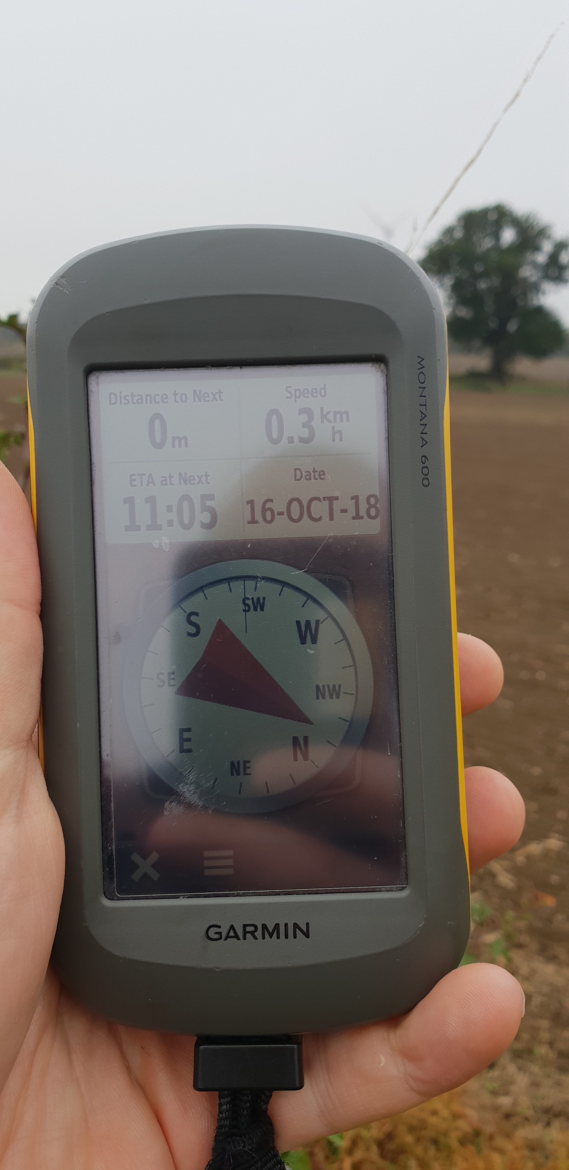
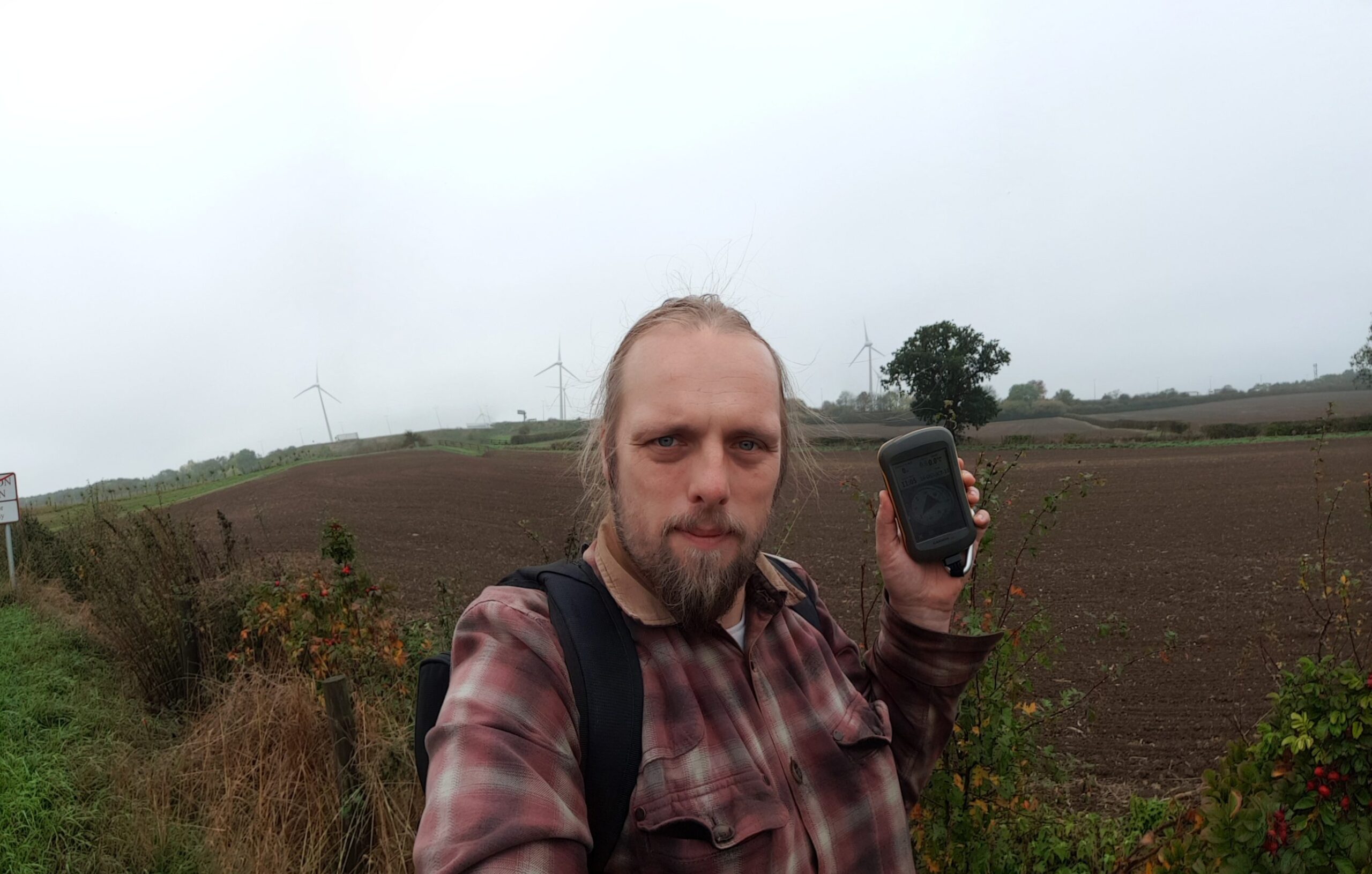
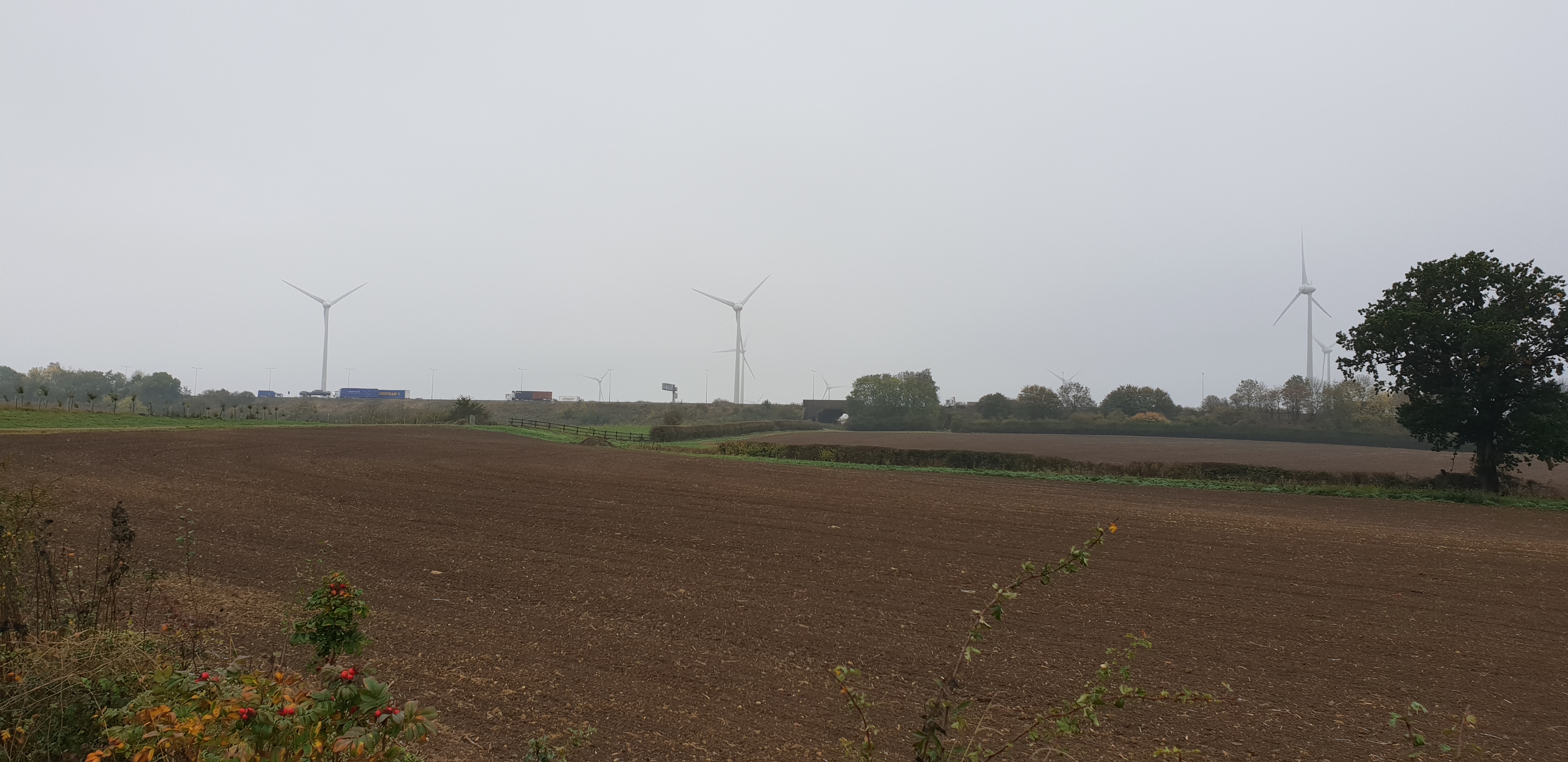
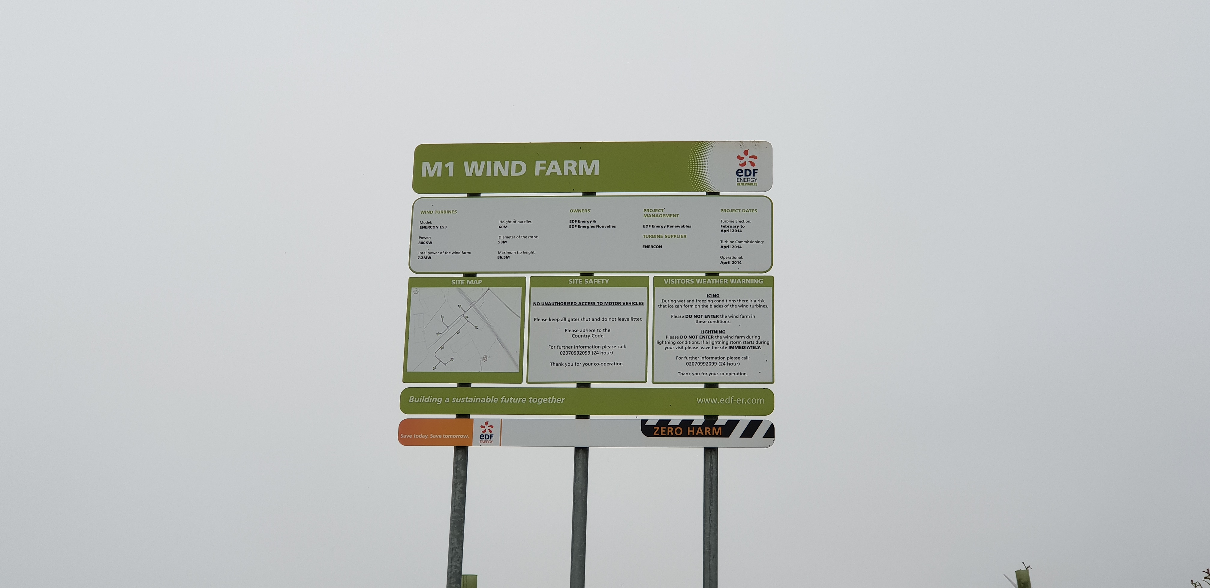
Failed to turn on the tracklogger on my GPS, but I remembered to get photos at least. This was a quick and easy run, although I did get accosted by a local who saw me hanging around near the wind farm and putting up a sign… I think that after the controversy these epic windmills caused he might have thought that I was putting up a planning notice to erect some more or something. Once I explained what I was doing he seemed happy enough.
Used my new 360° full-panoramic camera to take a picture at the hashpoint; I’ll put a VR-ready version on my website and link it here when I get the chance.
This is a repost promoting content originally published elsewhere. See more things Dan's reposted.
…
The history of the organisation known as OS is not merely that of a group of earnest blokes with a penchant for triangulation and an ever-present soundtrack of rustling cagoules.
From its roots in military strategy to its current incarnation as producer of the rambler’s navigational aid, the government-owned company has been checking and rechecking all 243,241 sq km (93,916 sq miles) of Great Britain for 227 years. Here are some of the more peculiar elements in the past of the famous map-makers.
…
This is a repost promoting content originally published elsewhere. See more things Dan's reposted.
…
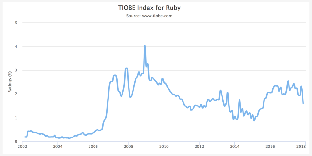
By 2005, Ruby had become more popular, but it was still not a mainstream programming language. That changed with the release of Ruby on Rails. Ruby on Rails was the “killer app” for Ruby, and it did more than any other project to popularize Ruby. After the release of Ruby on Rails, interest in Ruby shot up across the board, as measured by the TIOBE language index:
It’s sometimes joked that the only programs anybody writes in Ruby are Ruby-on-Rails web applications. That makes it sound as if Ruby on Rails completely took over the Ruby community, which is only partly true. While Ruby has certainly come to be known as that language people write Rails apps in, Rails owes as much to Ruby as Ruby owes to Rails.
…
As an early adopter of Ruby (and Rails, when it later came along) I’ve always found that it brings me a level of joy I’ve experienced in very few other languages (and never as much). Every time I write Ruby, it takes me back to being six years old and hacking BASIC on my family’s microcomputer. Ruby, more than any other language I’ve come across, achieves the combination of instant satisfaction, minimal surprises, and solid-but-flexible object orientation. There’s so much to love about Ruby from a technical perspective, but for me: my love of it is emotional.
This is a repost promoting content originally published elsewhere. See more things Dan's reposted.
Dear Guy Who Can’t Read The Room:
Hello and thank you for attempting to engage in an unsolicited conversation with me! In order to ensure our interaction is productive and enriching for both parties, I invite you to join my Matreon. For just a few dollars a month, you can continue to approach me with whatever the hell is on your mind regardless of context or appropriateness, and I will continue to do the emotional labor required to respond without calling you a privileged, myopic dipshit.
Since you’re obviously the most important person in the universe and everything should cater to your needs, I’ve created a number of exciting options that you can take advantage of. You know, like you take advantage of the way that women are culturally trained to be sweet and helpful when you fart words in their direction.
…
You know what: there are probably guys who’d pay for this and would then use their doing so as an illustration that women “need men to (financially) support them”.
This is a repost promoting content originally published elsewhere. See more things Dan's reposted.
When Firefox 64 arrives in December, support for RSS, the once celebrated content syndication scheme, and its sibling, Atom, will be missing.
“After considering the maintenance, performance and security costs of the feed preview and subscription features in Firefox, we’ve concluded that it is no longer sustainable to keep feed support in the core of the product,” said Gijs Kruitbosch, a software engineer who works on Firefox at Mozilla, in a blog post on Thursday.
…
Not a great sign, but understandable. Live Bookmarks was never strong enough to be a full-featured RSS reader, and I don’t know about you but I haven’t really made use of bookmarks for a good few years, let alone “live” bookmarks, but the media are likely to see this (as El Reg does, in the article) as another nail in the coffin of one of the best syndication mechanisms the Web ever came up with.
Some days, my day job doesn’t seem like a job that a real person would have at all. It seems like something out of a sitcom. Today, I have:
Not every day is like this. But sometimes, just sometimes, one can be.
This is a repost promoting content originally published elsewhere. See more things Dan's reposted.
…
Now, it’s Saturday morning and you’re eager to try out what you’ve learned. One of the first things the manual teaches you how to do is change the colors on the display. You follow the instructions, pressing
CTRL-9to enter reverse type mode and then holding down the space bar to create long lines. You swap between colors usingCTRL-1throughCTRL-8, reveling in your sudden new power over the TV screen.As cool as this is, you realize it doesn’t count as programming. In order to program the computer, you learned last night, you have to speak to it in a language called BASIC. To you, BASIC seems like something out of Star Wars, but BASIC is, by 1983, almost two decades old. It was invented by two Dartmouth professors, John Kemeny and Tom Kurtz, who wanted to make computing accessible to undergraduates in the social sciences and humanities. It was widely available on minicomputers and popular in college math classes. It then became standard on microcomputers after Bill Gates and Paul Allen wrote the MicroSoft BASIC interpreter for the Altair. But the manual doesn’t explain any of this and you won’t learn it for many years.
One of the first BASIC commands the manual suggests you try is the
PRINT "COMMODORE
                64"
, slowly, since it takes you a while to find the quotation mark symbol above the2key. You hitRETURNand this time, instead of complaining, the computer does exactly what you told it to do and displays “COMMODORE 64” on the next line.Now you try using the
?, since the manual has advised you that?is an abbreviation for…
I had an Amstrad CPC, myself, but I had friends with C64s and ZX Spectrums and – being slightly older than the author – I got the opportunity to experiment with BASIC programming on all of them (and went on to write all manner of tools on the CPC 464, 664, and 6128 models). I’m fortunate to have been able to get started in programming in an era when your first experience of writing code didn’t have to start with an examination of the different language choices nor downloading and installing some kind of interpreter or compiler: microcomputers used to just drop you at a prompt which was your interpreter! I think it’s a really valuable experience for a child to have.
This is a repost promoting content originally published elsewhere. See more things Dan's reposted.
For a philosopher, Helen Nissenbaum is a surprisingly active participant in shaping how we collect, use, and protect personal data. Nissenbaum, who earned her PhD from Stanford, is a professor of information science at Cornell Tech, New York City, where she focuses on the intersection of politics, ethics, and values in technology and digital media — the hard stuff. Her framework for understanding digital privacy has deeply influenced real-world policy.
In addition to several books and countless papers, she’s also coauthored privacy plug-ins for web browsers including TrackMeNot, AdNauseum, and Adnostic. Nissenbaum views these pieces of code as small efforts at rationalizing a marketplace where opaque consent agreements give consumers little bargaining power against data collectors as they extract as much information, and value from this information, as they can. Meanwhile, these practices offer an indefinite value proposition to consumers while compromising the integrity of digital media, social institutions, and individual security.
…
This is a repost promoting content originally published elsewhere. See more things Dan's reposted.
Fundamentally, people haven’t changed much in tens of thousands of years. If ancient Egyptians had smartphones, you know full well that they’d have been posting cat pictures too. What can we learn from this and how should we look at our role when developing front-end Web experiences?
This is a repost promoting content originally published elsewhere. See more things Dan's reposted.
There are two stories here. The first is a story about a vision of the web’s future that never quite came to fruition. The second is a story about how a collaborative effort to improve a popular standard devolved into one of the most contentious forks in the history of open-source software development.
In the late 1990s, in the go-go years between Netscape’s IPO and the Dot-com crash, everyone could see that the web was going to be an even bigger deal than it already was, even if they didn’t know exactly how it was going to get there. One theory was that the web was about to be revolutionized by syndication. The web, originally built to enable a simple transaction between two parties—a client fetching a document from a single host server—would be broken open by new standards that could be used to repackage and redistribute entire websites through a variety of channels. Kevin Werbach, writing for Release 1.0, a newsletter influential among investors in the 1990s, predicted that syndication “would evolve into the core model for the Internet economy, allowing businesses and individuals to retain control over their online personae while enjoying the benefits of massive scale and scope.”1 He invited his readers to imagine a future in which fencing aficionados, rather than going directly to an “online sporting goods site” or “fencing equipment retailer,” could buy a new épée directly through e-commerce widgets embedded into their favorite website about fencing.2 Just like in the television world, where big networks syndicate their shows to smaller local stations, syndication on the web would allow businesses and publications to reach consumers through a multitude of intermediary sites. This would mean, as a corollary, that consumers would gain significant control over where and how they interacted with any given business or publication on the web.
RSS was one of the standards that promised to deliver this syndicated future. To Werbach, RSS was “the leading example of a lightweight syndication protocol.”3 Another contemporaneous article called RSS the first protocol to realize the potential of XML.4 It was going to be a way for both users and content aggregators to create their own customized channels out of everything the web had to offer. And yet, two decades later, RSS appears to be a dying technology, now used chiefly by podcasters and programmers with tech blogs. Moreover, among that latter group, RSS is perhaps used as much for its political symbolism as its actual utility. Though of course some people really do have RSS readers, stubbornly adding an RSS feed to your blog, even in 2018, is a reactionary statement. That little tangerine bubble has become a wistful symbol of defiance against a centralized web increasingly controlled by a handful of corporations, a web that hardly resembles the syndicated web of Werbach’s imagining.
The future once looked so bright for RSS. What happened? Was its downfall inevitable, or was it precipitated by the bitter infighting that thwarted the development of a single RSS standard?
…
I’ve always been a huge fan of RSS, and I use it for just about everything (I’ll even hack-it-in to services that don’t supply it natively, just to make them fit around my workflow). But even I’ve got to admit that – outside of podcasts – it’s not done well at retaining mainstream appeal, especially after the death of Google Reader. Right now, most people seem content to get their updates from their social media circles, and take a manual approach (ugh) to reading content in the few other places that matter to them. That’s problematic for all kinds of reasons, and I’m perfectly happy to be one of those old fuddy-duddies who likes his web standards open and independent!
This review of Malmaison Oxford originally appeared on Google Maps. See more reviews by Dan.
Delightful, although expensive, hotel. Theming is spot-on: you can really see the architecture that once made this place a prison, while simultaneously chilling out in a level of luxury that would have been completely unknown to its original inhabitants. Excellent service and good amenities – you could lock me up here any day… if the prices didn’t send me to the gallows first!
This review of Fairytale Farm originally appeared on Google Maps. See more reviews by Dan.
A bit weird, but if you’re looking for an eccentric (but good value) outing with young children, it fits the bill. Very good disabled accessibility.
This review of Islip Village Shop originally appeared on Google Maps. See more reviews by Dan.
Remarkably good prices and friendly staff. Often a selection of local produce as well as a wide variety of the usual convenience store essentials. Plenty of space to park cars and bikes, but equally accessible by foot.
This is a repost promoting content originally published elsewhere. See more things Dan's reposted.
A11Y Nutrition Cards is an attempt to digest and simplify the accessibility expectations when it comes to component authoring. Based on the WAI ARIA Authoring Practices Guide.
…