Oxford’s Long-Lost Zoo and Wild Wolves

It’s been a while since I last hid geocache containers and it felt like it was time I gave a back some more to the community, especially as the “village” I live in has a lower cache density than it deserves (conversely, Oxford City Centre is chock-full of uninspiring magnetic nanos – although it’s improving – and saturated with puzzle caches that ultimately require a trek well outside the ring road). I’ve never been a heavyweight score-counting ‘cacher, but I’ve always had a soft spot for nice containers as large as their hiding place will permit coupled with well thought-out pieces of local interest, and that’s the kind of cache I wanted to add to my local area.

Annabel helps hunt for a place to hide a small clip-lock box (with attached chain).
Plus, my second-smallest caching-buddy was keen on getting involved with hiding containers rather than just finding them for me.

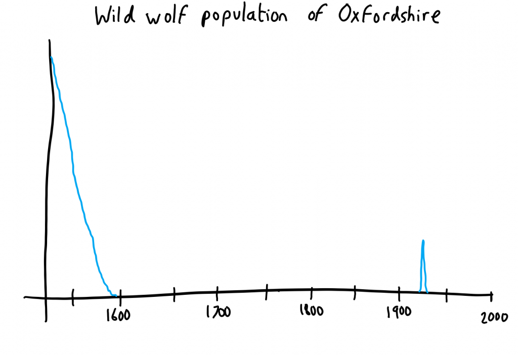
So imagine my joy when I discover a little-known piece of history about my village: that for a few years in the 1930s, we used to have a zoo! And I’m not talking about something on the scale of that place with the meercats that we used to go to: I’m talking about a proper zoo with lions and tigers and bears (oh my!). Attractions like Rosie the elephant and Hanno the lion would get mentioned in the local newspapers at every excuse, and a special bus service connected Oxford city centre to the entrance to the zoo, just outside then (then much-smaller) Kidlington village.

Entrance to Oxford Zoo
I’ve stood at the spot from which this photo was taken, and I couldn’t recognise it. A new boulevard, houses, a police station and a leisure centre dominate the view today.

Taking advantage of my readers’ card at the Bodleian Library, I was able to find newspapers and books and piece together the history of this short-lived place. Of particular interest were the unusual events of January 1937, when three wolves escaped from the zoo and caused chaos in the surrounding village and farms for several days. In a tale that sounds almost like a Marvel Comic origin story, the third wolf was eventually shot by local press photographer Johnny Johnson who chased the animal down on a borrowed bicycle.

Graph of the wild wolf population of Oxfordshire
Wild wolves in Oxfordshire were driven to extinction in the 16th century, but made a tiny comeback for a few days in the 1930s.

This formed the essence of our new geocaches: we planned four geocaches –

  1. Oxford’s Long-Lost Zoo (GC7Q96B / OK0456), representing the zoo and hidden at a corner of what used to be the grounds
  2. Oxford’s Wild Wolf One (GC7Q9E6 / OK0457), representing the first escaped wolf and hidden near to a garden it jumped into
  3. Oxford’s Wild Wolf Two (GC7Q9FF / OK0458), representing the second escaped wolf and hidden near to where it was shot by a farmer and his son
  4. Oxford’s Wild Wolf Three – not yet placed, but we’re planning a multicache series that follows places that the third wolf might have travelled through during its extended escape (the third wolf managed to stay at large for long enough to allegedly kill 13 sheep)
Decorated ammo can cache
Sticking to my aim of larger, higher-quality caches, the “zoo” cache is a decorated ammo can filled with toy animals.

Soon after the first three caches went live they were found by a local ‘cacher whose hides I’ve enjoyed before. She had nice things to say about the series, so that’s a good sign that we’re thinking in the right kind of direction. The bobbin – who’s taken a bit of an interest in local history this month and keeps now asking about the ages of buildings and where roads used to go and things – is continuing to help me set out places to hide the parts of the final cache in the series, Oxford’s Wild Wolf Three, so further excitement no-doubt awaits.

× × ×

Dan Q found GLVYGYQ1 Easy as 1-2-3!

This checkin to GLVYGYQ1 Easy as 1-2-3! reflects a geocaching.com log entry. See more of Dan's cache logs.

Given that I live very close to this cache (and have done since well before it was placed) I hope you’d forgive me for taking my time to getting around to solving and logging it. Because I was solving GC5R4B3 (Boggling Boolean) today anyway, I thought I’d take a proper look at this for the first time. A quick Google search confirmed my suspicions about what I was looking at and gave me the necessary resources to learn how to read it, and then I was on my way by bike to the general area. I went via GC5R4B3 where I unfortunately left my pen, meaning that I didn’t have it with me when I got to this cache!

Therefore, by way of proof-of-finding, I’ve attached a (non-spoilery) photo of the log from the cache, sitting atop my GPSr whose screen is showing my name and the current date. If CO really wants me to go back up and sign it for-real than I will, but I’ll tell you what: I’m wearing long trousers (or taking a lawnmower) next time!

Lovely cache container in a place I didn’t even know existed; thanks!

Oh, and also: by some counts (this site’s, i.e. ignoring caches logged on other sites) this is my 400th cache. So that’s nice.

My GPSr and the cache log

Dan Q found GLVYGRN8 Boggling Boolean

This checkin to GLVYGRN8 Boggling Boolean reflects a geocaching.com log entry. See more of Dan's cache logs.

Given that I’ve lived very near to here for longer than this cache has existed, you’d be forgiven for wondering what took me so long. I don’t even have the excuse that many might: that the array of strange symbols, lines, and letters might be too puzzling for me, but that’s not the case either! When the cache first appeared I instantly recognised the language that was being used: I just couldn’t work out how that could be used to express a set of GPS coordinates.

Today, at long last, I thought to look at the hint. I can’t believe it’s been years and I hadn’t: I guess I’d assumed that it would have only helped me with the location of the actual container, more fool me. Anyway: once I read the hint, I instantly knew what I had to do. I was feeling lazy, so I translated the code into a slightly different format and punched it into an online service that can help with this kind of thing, and suddenly I was over 80% of the way there. But one digit (the fourth) was throwing me off… it seemed to be giving me a result that didn’t MEAN anything. Only when I stopped and thought about what a particular letter might represent did I realise my folly!

A short cycle later and the cache was in my hand: it was in the first place I looked. Unfortunately a part of the cache container flew off and attached itself to a hard-to-reach spot on my bike, and it took me a while to put the container back together again! Worse yet, while undoing the damage I’d caused (it’s fine now, by the way) I dropped my pen, which meant that I didn’t have it with me when I reached my next cache stop, GC6HV83 (Easy as 1-2-3), but more on that later.

FP awarded.

Pen I lost at the GZ and had to come back for.

Dan Q found GLVYAZGY University Challenge 8 (Brmm Brmm)

This checkin to GLVYAZGY University Challenge 8 (Brmm Brmm) reflects a geocaching.com log entry. See more of Dan's cache logs.

Visited the old multicache that use to be near here, years ago, and somehow neglected to return to get this virtual when it appeared. Made it, though, earlier this week. (Answers/pic to follow. ) TFTC.

Dan Q posted a note for GC3MKRH Dogfort v Catfort – Catfort

This checkin to GC3MKRH Dogfort v Catfort - Catfort reflects a geocaching.com log entry. See more of Dan's cache logs.

With 6 of the 12 prerequisite caches now archived (after the CO didn’t respond to queries, we’re told), it seems unlikely that anybody’s left who’s both able and willing to find this cache. It was last logged over 5 months ago by a cacher who suspects that they’ll be the last; the previous log was over a year and a quarter before that. Perhaps time to archive?

Earth-Moon Fire Pole

This article is a repost promoting content originally published elsewhere. See more things Dan's reposted.

Earth-Moon Fire Pole (what-if.xkcd.com)

Earth-Moon Fire Pole My son (5y) asked me today: If there were a kind of a fireman’s pole from the Moon down to the Earth, how long would it take to slide all the way from the Moon to the Earth? Ramon Schönborn, Germany First, let’s get a few things out of the way: In…

How To Set Up an OSRM Server on Ubuntu 14.04

This article is a repost promoting content originally published elsewhere. See more things Dan's reposted.

How To Set Up an OSRM Server on Ubuntu 14.04 | DigitalOcean (DigitalOcean)

The OpenStreetMap project consists of raw map data, collected and aggregated by thousands of users. This tutorial covers the configuration and maintenance of a web service using Open Source Routing Machine (OSRM), which is based on the OpenStreetMap d

The OpenStreetMap project consists of raw map data, collected and aggregated by thousands of users. However, its open access policy sparked a number of collateral projects, which collectively cover many of the features typically offered by commercial mapping services.

The most obvious advantage in using OpenStreetMap-based software over a commercial solution is economical convenience, because OpenStreetMap comes as free (both as in beer and as in speech) software. The downside is that it takes a little configuration in order to setup a working web service.

This tutorial covers the configuration and maintenance of a web service which can answer questions such as:

  • What is the closest street to a given pair of coordinates?
  • What’s the best way to get from point A to point B?
  • How long does it take to get from point A to point B with a car, or by foot?

The software that makes this possible is an open-source project called Open Source Routing Machine (OSRM), which is based on the OpenStreetMap data. Functionalities to embed OpenStreetMaps in Web pages are already provided out-of-the-box by APIs such as OpenLayers.

While slightly dated, I found this guide to be really valuable in my effort to set up a server that could spit out fastest walking routes around Oxford to support a PWA-driven tour of places relevant to J. R. R. Tolkien’s life, at my “day job”.

Maps Showing California as an Island – The Public Domain Review

This article is a repost promoting content originally published elsewhere. See more things Dan's reposted.

http://publicdomainreview.org/collections/maps-showing-california-as-an-island/ (publicdomainreview.org)

If California were a country its economy would be the fifth largest in the world (just ahead of the UK). Yet the tech boom is not the starkest way California has ever stood apart from its neighbours. That would surely be the maps depicting it as an island, entire of itself. Below we have featured our pick of these glorious seventeenth- and eighteenth-century aberrations, from a collection of hundreds held at Stanford.

The intriguing story of how the maps came to be deserves a little mapping itself. In the 1530s Spanish explorers led by Hernán Cortés encountered the strip of land we now know as the Baja Peninsula. They mistook it for an island and called it California.

Dan Q found OK0022 Copdock Hill

This checkin to OK0022 Copdock Hill reflects an opencache.uk log entry. See more of Dan's cache logs.

A planned break from my journey from Oxford to Preston gave me the opportunity for a sunset hill climb in this beautiful setting. Almost as if to congratulate me, the second I returned the log to the cache container somebody far to the South West started setting off fireworks (barely audible from this distance, but definitely visible from this altitude!): I must be doing something right! TFTC.

Dan Q found OK0372 Mandala

This checkin to OK0372 Mandala reflects an opencache.uk log entry. See more of Dan's cache logs.

A moment of joy and serenity on my otherwise-uninspiring cycle to work. A wonder I’ve never been down this end of Plantation Road before, given that I’m a fan of the Gardner’s Arms further along it and there are certainly journeys I’ve taken to or from there that would have been just as easy to take via this end of the quaint street.

I tried looking at the mandala image in two different cardinal directions, and saw that it appeared in two different ways. Upright, it seems as though an infinity symbol divided (but you can divide infinity forever and still have an infinity), but rotated 90° it’s more like an hourglass suspended in a rotating frame (and so able to be flipped and started again). Either way, the metaphor to me is one of time.

Thanks for the cache; I hope more people get to find their way to this magical little corner.