At the moment at which he described the machine’s success, I completely lost it.
Baby Burping Robot
This is a repost promoting content originally published elsewhere. See more things Dan's reposted.
This is a repost promoting content originally published elsewhere. See more things Dan's reposted.
At the moment at which he described the machine’s success, I completely lost it.
This is a repost promoting content originally published elsewhere. See more things Dan's reposted.
A wise man once said “To Infinity and Beyond”, Unfortunately there’s no way of knowing who that man was or in what context it was meant to be understood, so let us instead turn our attention to the Toy Story porn parody – Sex Toy Story The XXX Parody Part 1.
It says Part 1, but I searched and there’s no Part 2. Unless they’re doing like a Toy Story 3 thing where they wait like ten years for Andy to grow up and go off to college, in which case we will have to wait with bated breath for ten years for Part 2.

We open on an unnamed woman played by Veruca James (Lesbian Anal Vampires, Emo Teen Fucks at Work) getting ready to masturbate. She does so the normal way we all do, by rubbing her clothed body.
…
“Does it exist?”, I asked, when the conversation drifted perilously close to this topic. Well of course it exists: Rule 34, duh. I was so glad that this article existed, to spare me from having to watch it to work out how much I didn’t want to watch it. Now all I have to do is scrub the idea of this article from my mind, which is hopefully easier than the retina-burning image of the film itself would have been.
Resulting link NSFW, obviously.
This is a repost promoting content originally published elsewhere. See more things Dan's reposted.
CSS before JS #
My general rule of thumb is…
If something I want to do with JavaScript can be done with CSS instead, use CSS.
CSS parses and renders faster.
For things like animations, it more easily hooks into the browser’s refresh rate cycle to provide silky smooth animations (this can be done in JS, too, but CSS just makes it so damn easy).
And it fails gracefully.
A JavaScript error can bring all of the JS on a page to screeching halt. Mistype a CSS property or miss a semicolon? The browser just skips the property and moves on. Use an unsupported feature? Same thing.
…
This exactly! If you want progressive enhancement (and you should), performance, and the cleanest separation of behaviour and presentation, the pages you deliver to your users (regardless of what technology you use on your server) should consist of:
Developers failing to follow this principle is making the Web more fragile and harder to archive. It’s not hard to do things “right”: we just need to make sure that developers learn what “right” is and why it’s important.
Incidentally, I just some enhancements to the header of this site, including some CSS animations on the logo and menu (none of them necessary, but all useful) and some Javascript to help ensure that users of touch-capable devices have an easier time. Note that neither Javascript nor CSS are required to use this site; they just add value… just the way the Web ought to be (where possible).
This is a repost promoting content originally published elsewhere. See more things Dan's reposted.
Is it just me, or is this some fantastic fucking casting. For the first time perhaps ever, I feel confident that a remake of an already-good film has the potential to be awesome.
This is a repost promoting content originally published elsewhere. See more things Dan's reposted.
There’s been a lot of talk about the missionary killed by the natives of North Sentinel Island. They’re probably so aggressive because of this weirdo, Maurice Vidal Portman. So here’s a big thread about this creep and some facts from my decade-long obsession with the island.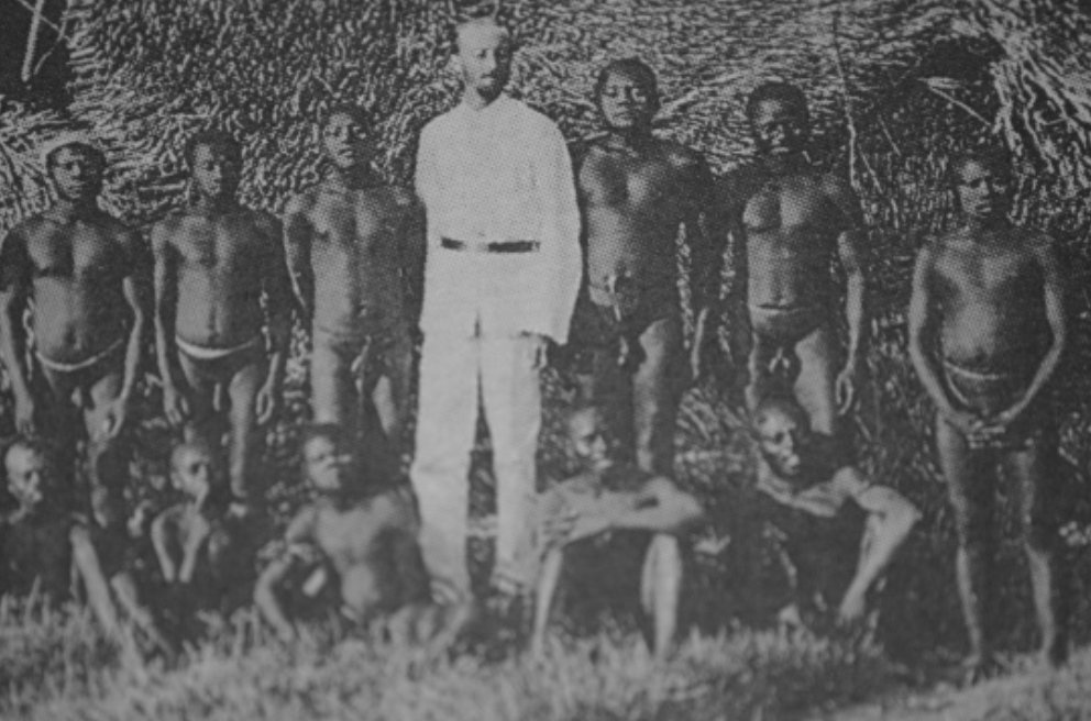 The Sentinelese are often described as “uncontacted,” but this not strictly true. They had a very significant contact in 1880 with Commander Portman.Portman, the black sheep third son of some minor noble, was assigned by the English Royal Navy to administer and pacify the Andaman Islands, a job he pursued from 1880-1900 with the full measure of his own perversity.
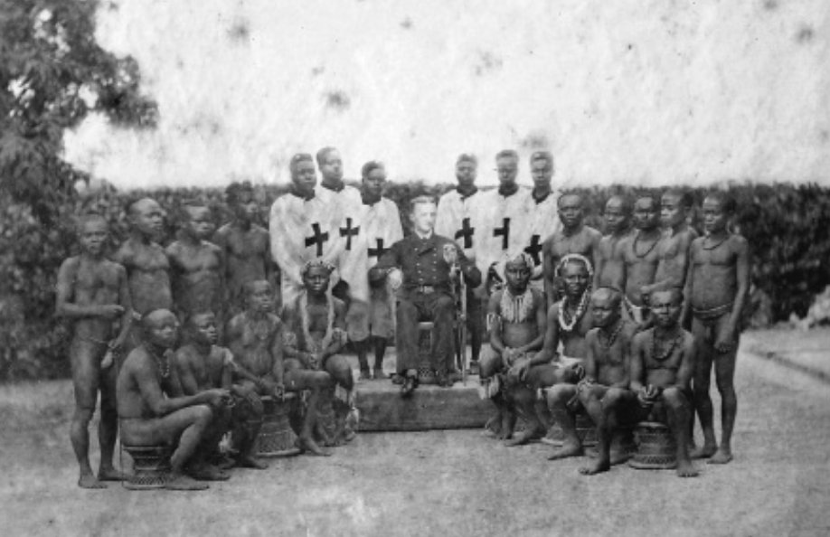 Portman was erotically obsessed with the Andamanese, and he indulged his passion for photography by kidnapping members of various tribes and posing them in mock-Greek homoerotic compositions.
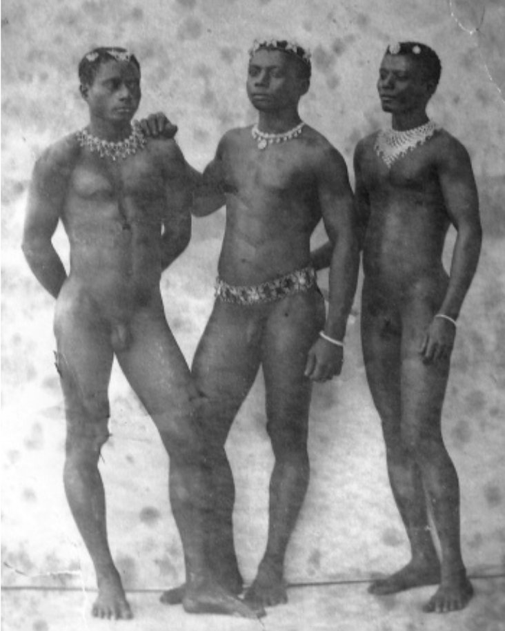 During his 20 years in a sexualized heart of darkness, Portman measured and cataloged every inch of his prisoner’s bodies, with an obsessive focus on genitals.
 Just imagine being a Neolithic person spending a few weeks in this guy’s rotating menagerie.
 Portman spent most of his time in the greater Andaman Islands, but in 1880, he landed on North Sentinel. The natives fled, and his party ventured inland to find a settlement which had been abandoned in haste.But they located an elderly couple and a few children they were able to abduct. The couple quickly died, likely from ailments to which they had no immunity.The children spent a few weeks with Portman doing god knows what, after which he returned them to the island. Portman returned on a couple occasions, but the Sentinelese hid from him each time.The story related by the children was certainly passed down among the 100 or so inhabitants of the island, and even today, Portman’s fatal kidnapping is just beyond a human lifetime.So when the Indian government attempted contact with anthropologists in the 1960s and 70s, the Sentinelese were understandably hostile to outsiders. The Indian government soon gave up.In 1981, a cargo ship named The Primrose ran aground on the coral reef surrounding North Sentinel. The crew radioed for assistance and settled in for a long wait. But in the morning they saw 50 men with bows on the beach, building makeshift boats.
 The crew called for an emergency airlift and were evacuated, and not a moment too soon. Rough waves had thwarted the Sentinelese in their attempts to board, but the weather was clearing.
 The ship and its cargo were left at the island, awaiting discovery by Neolithic eyes. Today you can still see the gutted remains on The Primrose on Google Earth.
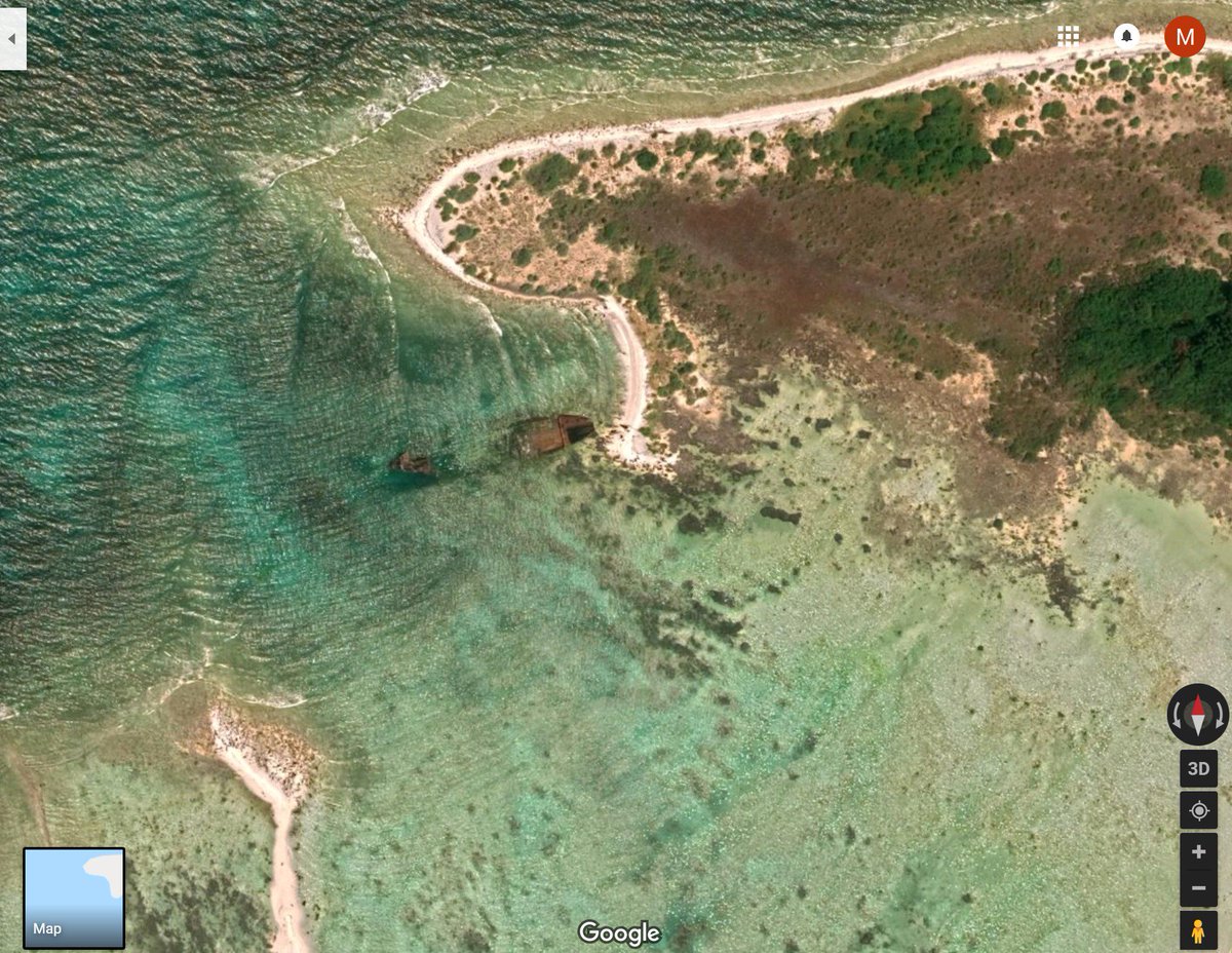 Imagine climbing on board that ship. A completely alien vessel filled with alien things. Imagine seeing simple machines for the first time. A hinge. A latch. A wheel. Things that would instantly make sense in a satisfying way. Others would be so incomprehensible to avoid notice.I have never been able to find out what cargo was on The Primrose in all my years of reading. There was about 100 tons of some sort of consumer product on board, and I’m curious what it was. But even absent the cargo, think about all the things that must have been on that ship.In the 1990s, when anthropologists returned to the island to make new attempts at contact, they were met with a different attitude. Not friendly, exactly. But they were willing to accept gifts. Many would wade into the water with smiles to accept coconuts.
Here is a video of one of those encounters:
And in those videos, you can see that these pre-iron age people now had metal weapons, like the knife carried by this man. They had scavenged metal from the Primrose and cold-forged it into tools.
 After collecting gifts for a few minutes, a few members of the tribe would approach and make menacing gestures, signaling that it was time for the outsiders to leave. They have never lost their desire for isolation, despite the gifts.And they remained consistent in their intolerance against intruders. In 2006, two fishermen were killed after drifting into the island when their anchor detached while they were sleeping.
 The Sentinelese are lucky they were so effective at preventing contact. The neighboring Jawara weren’t so fortunate. The tribe went from 9,000 to a couple hundred from lack of genetic immunity and only forestalled annihilation due to aggressive segregation. Their future is bleak.Yet on North Sentinel, they’ve maintained a small community for 60,000 years which is by all indications happy. There is no way to integrate them into the modern world without wiping out nearly every member of their tribe.And their aggressiveness is not the mark of savagery. It just that their conception of outsiders is mostly framed by some foot-faced English pervert who murdered some old people and did weird things to their kids. So let’s do them a favor and leave them alone.
This is a repost promoting content originally published elsewhere. See more things Dan's reposted.
I’m not cryin, you’re crying. Shut up. It’s just really dusty in here. And I think somebody must have been cutting onions.
This is a repost promoting content originally published elsewhere. See more things Dan's reposted.
For the past month or two, my place of work (this very website) has been plagued by a relatively harmless but deeply mystifying figure: the phantom lunch thief. What’s happened since has followed a trajectory sure to be familiar to anyone who’s ever worked in an office with more than, say, 30 employees: a menacing, all-caps Post-It note was posted, instructing the thief: “PLEASE DO NOT TAKE FOOD THAT DOESN’T BELONG TO YOU.” The appropriate authorities were alerted. The authorities sent out slightly mean emails about how we’re all adults here, and even those of us who didn’t do anything wrong were embarrassed. For a few days, no lunches were stolen. But then, just when you thought it was safe to leave an Amy’s frozen burrito in the shared fridge for 12 days, the lunch thief struck again. Collectively, and publicly — all wanting to make very clear that we were innocent — my colleagues and I wondered: who does this? What kind of person steals lunch from people they work with, and why?
To find out, I had to identify one such person. First, I offered my own office lunch thief immunity (or, well, anonymity) if they came forward to tell me their life story, but nobody took me up on it. I asked Twitter, where many people expressed outrage over the very idea of lunch theft, but again, no actual thieves surfaced. I even made a Google Form about it, and nobody filled out my Google Form. I was very nearly too dejected to continue my search when I remembered: Reddit. If not there, where?
On Reddit, I found a few lunch theft discussion threads, and messaged about 15 or 20 users who indicated that they had stolen, or would steal, lunch from a co-worker, several of whom sounded very pleased with themselves. I told them I was a reporter, and asked if they’d be willing to elaborate on their experiences in lunch theft. Unfortunately, most relevant postings I found were from, like, four years ago, and again it seemed no one would come forward. But then someone wrote me back. Eventually he agreed to speak with me, and we arranged a phone call. His name is Rob, and he’s a programmer in his early 40s. Together we decided there are probably enough programmers in their 40s named Rob that divulging this amount of personal information was okay.
…
As a non-lunch-stealer, I’ve never understood the mentality either (I’ve been the victim once or twice at work, at more-often way back when I lived in student accommodation), and this interview really helped to humanise a perpetrator. I still can’t condone it, but at least now I’ve got a greater understanding. Yay, empathy!
When I watched @Sir_RidleyScott’s #BrainDead (@BrainDeadCBS) in 2016, it was a dark comedy about alien brain parasites driving US political extremism.
When I watched it in 2018 it was a plausible explanation.
When I watch it in 2020 I’m worried it will be a documentary.

Hey @aqldotcom: why must my password for your enterprise telecommunications platform be no longer than 12 characters? Are you worried my #passwordistoostrong? CC @pwtoostrong
This is a repost promoting content originally published elsewhere. See more things Dan's reposted.
Anna Trupiano is a first-grade teacher at a school that serves deaf, hard-of-hearing, and hearing students from birth through eighth grade.
In addition to teaching the usual subjects, Trupiano is charged with helping her students thrive in a society that doesn’t do enough to cater to the needs of the hard-of-hearing.
Recently, Trupiano had to teach her students about a rather personal topic: passing gas in public.
A six-year-old child farted so loud in class that some of their classmates began to laugh. The child was surprised by their reaction because they didn’t know farts make a sound. This created a wonderful and funny teaching moment for Trupiano.
Trupiano shared the conversation on Facebook.
…
This is a repost promoting content originally published elsewhere. See more things Dan's reposted.

Jigsaw puzzle companies tend to use the same cut patterns for multiple puzzles. This makes the pieces interchangeable, and I sometimes find that I can combine portions from two or more puzzles to make a surreal picture that the publisher never imagined. I take great pleasure in “discovering” such bizarre images lying latent, sometimes for decades, within the pieces of ordinary mass-produced puzzles.
…
Since changing my surname 11½ years ago to the frankly-silly (albeit very “me”) Q, I’ve faced all kinds of problems, from computer systems that don’t accept my name to a mocking from the Passport Office to getting banned from Facebook. I soon learned to work-around systems that insisted that surnames were at least two characters in length. This is a problem which exists mostly because programmers don’t understand how names work in the real world (or titles, for that matter, as I’ve also discovered).
It’s always been a bit of an inconvenience to have to do these things, but it’s never been a terrible burden: even when I fly internationally – which is probably the hardest part of having my name – I’ve learned the tricks I need to minimise how often I’m selected for an excessive amount of unwanted “special treatment”.

This year, though, for the very first time, my (stupid bloody) unusual name paid for itself. And not just in the trivial ways I’m used to, like being able to spot my badge instantly on the registration table at conferences I go to or being able to fill out paper forms way faster than normal people. I mean in a concrete, financially-measurable way. Wanna hear?
So: I’ve a routine of checking my credit report with the major credit reference agencies every few years. I’ve been doing so since long before doing so became free (thanks GDPR); long even before I changed my name: it just feels like good personal data housekeeping, and it’s interesting to see what shows up.

And so I noticed that my credit report with Equifax said that I wasn’t on the electoral roll. Which I clearly am. Given that my credit report’s pretty glowing, I wasn’t too worried, but I thought I’d drop them an email and ask them to get it fixed: after all, sometimes lenders take this kind of thing into account. I wasn’t in any hurry, but then, it seems: neither were they –

I wasn’t in a hurry, and 2017 was a bit of a crazy year for me (for Equifax too, as it happens), so I ignored it for a bit, and then picked up the trail right after the GDPR came into force. After all, they were storing personal information about me which was demonstrably incorrect and, continued to store and process it even after they’d been told that it was incorrect (it’d have been a violation of principle 4 of the DPA 1998, too, but the GDPR‘s got bigger teeth: if you’re going to sick the law on somebody, it’s better that it has bark and bite).
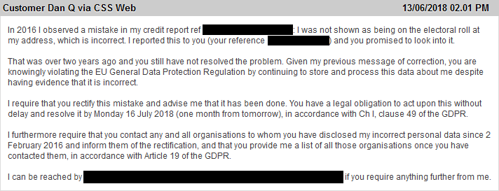
My anticipation was that my message of 13 July 2018 would get them to sit up and fix the issue. I’d assumed that it was probably related to my unusual name and that bugs in their software were preventing them from joining-the-dots between my credit report and the Electoral Roll. I’d also assumed that this nudge would have them either fix their software… or failing that, manually fix my data: that can’t be too hard, can it?
Apparently it can:
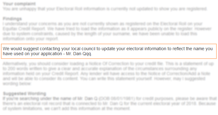
Equifax’s suggested solution to the problem on my credit report? Change my name on the Electoral Roll to match the (incorrect) name they store in their systems (to work around a limitation that prevents them from entering single-character surnames)!
At this point, they turned my send-a-complaint-once-every-few-years project into a a full blown rage. It’s one thing if you need me to be understanding of the time it can take to fix the problems in your computer systems – I routinely develop software for large and bureaucratic organisations, I know the drill! – but telling me that your bugs are my problems and telling me that I should lie to the government to work around them definitely isn’t okay.

At this point, I was still expecting them to just fix the problem: if not the underlying technical issue then instead just hack a correction into my report. But clearly they considered this, worked out what it’d cost them to do so, and decided that it was probably cheaper to negotiate with me to pay me to go away.
Which it was.
This week, I accepted a three-figure sum from Equifax as compensation for the inconvenience of the problem with my credit report (which now also has a note of correction, not that my alleged absence from the Electoral Roll has ever caused my otherwise-fine report any trouble in the past anyway). Curiously, they didn’t attach any strings to the deal, such as not courting publicity, so it’s perfectly okay for me to tell you about the experience. Maybe you know somebody who’s similarly afflicted: that their “unusual” name means that a credit reference company can’t accurately report on all of their data. If so, perhaps you’d like to suggest that they take a look at their credit report too… just saying.

Apparently Equifax think it’s cheaper to pay each individual they annoy than it is to fix their database problems. I’ll bet that, in the long run, that isn’t true. But in the meantime, if they want to fund my recent trip to Cornwall, that’s fine by me.
This is a repost promoting content originally published elsewhere. See more things Dan's reposted.
A few nights ago I saw Jack White in concert. It was a wonderful night, and a big part of that was due to a new rule he has imposed on all his tour dates: no phones.
When you arrive, you have to put your phone into a neoprene pouch, supplied by a company called Yondr, which they lock and give back to you. If you want to use your phone during the show, you can go into the concourse and unlock it by touching it to one of several unlocking bases. The concert area itself remains screen-free.
The effect was immediately noticeable upon entering the concert bowl. Aside from the time-travel-like strangeness of seeing a crowd devoid of blue screens, there was a palpable sense of engagement, as though—and it sounds so strange to say it—everyone came just so they could be there.
…
The most-significant observation in this article, in my mind, was that even putting a 20-second delay to people using their phones – that is, having to walk out to the concourse to unlock their bags – was sufficient to dramatically remove the temptation for their use. That’s amazing, but unsurprising: Veritasium recently did a video about boredom and how the desire to avoid ever feeling bored (despite its scientifically-demonstrable benefits), coupled with the easy access of instant stimulation from our smart devices, leads us into the well-known check phone, replace, check again cycle (or else “zombie smartphoning”).
I’ve been trying to be better about paying less-attention to my phone, this year, and it’s gone well… except that (as David also observes in the linked article) I’ve become more acutely aware of the feeling of the conversational/interpersonal “void” created when somebody else chances a “quick check” of their phone under the table. I used to blame social media mostly for this – and I still think that it’s an issue, and it’s certainly true that my Facebook/Twitter/Reddit-heavier-using friends are the biggest culprits for getting lost in their devices – but I’ve come to see it as a bigger, more-human issue, coupled with the availability of the new technologies around us.
Similar to how we eat too much fat, and sugar, and meat… simply because it’s available, we crave the stimulation that we can easily get from the device in our pocket to such an extent that we’ve become unhealthy in our habits.
This is a repost promoting content originally published elsewhere. See more things Dan's reposted.
Possibly the most-spectacular and well-delivered magic routine I’ve ever seen. I’ve watched it about a dozen times so far, and loved it every single one of them.
This checkin to GC1TYZW Gordano services Motorway Mayhem M5 J19 reflects a geocaching.com log entry. See more of Dan's cache logs.
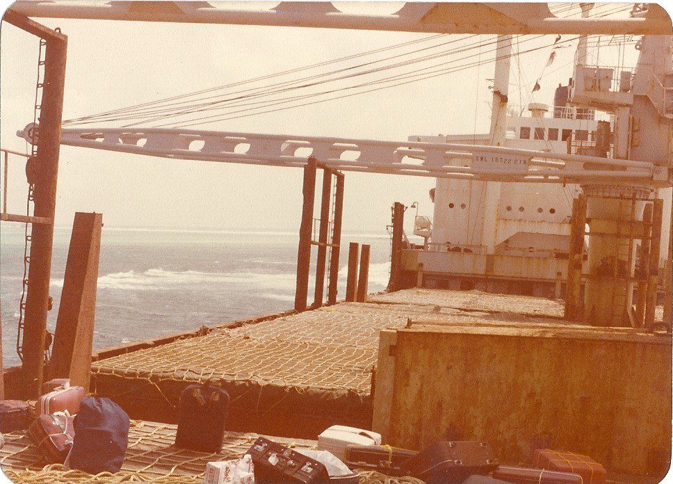
Stopped on the way back from Penzance to Oxford after a weekend in geocaching and geocaching-like activities, including introducing my partner’s brother to the sport while putting him through an adventure weekend I called Challenge Robin II. After the interminable A30 and a miserably rainy M5 I was pleased for the excuse to stop she stretch my legs, and doubly pleased when I discovered that there was a geocache in the vicinity.
No litter on the path, which was nice. Close to the GZ I soon spotted a geotrail and quickly had the container in my hand. TFTC!