EXIF geodata, and what if you took a picture on the moon?

This is a repost promoting content originally published elsewhere. See more things Dan's reposted.

A conversation about staying private and stripping EXIF tags on blogs lead to shdwcat asking the question “what would happen if you took a picture on the moon?”

However, I figured we could do better than “a point high above the Earth.” If you could state the coordinate system, you should be able to list an actual point on the moon.

It’s a fun question. Sure, you need to shoot down the naysayers who, like colin, rightly point out that you couldn’t reasonably expect to get a GPS/GNSS signal on the moon, but still.

GPS on Earth

GPS (and most other GNSS technologies) fundamentally work by the principle of trilateration. Here’s the skinny of what happens when your GPS receiver – whether that’s your phone, smartwatch, SatNav, or indeed digital camera – needs to work out where on Earth it is:

  1. It listens for the signal that’s transmitted from the satellites. This is already an amazing feat of engineering given that the signal is relatively quiet and it’s being transmitted from around 20,000km above the surface of the planet1.
  2. The signal fundamentally says, for example “Hi, I’m satellite #18, and the time is [some time].” Assuming your GPS receiver doesn’t contain an atomic clock2, it listens for the earliest time – i.e. the closest satellite (the signals “only” travel at the speed of light) – and assumes that this satellite’s time represents the actual time at your location.
  3. Your GPS receiver keeps listening until it’s found three more satellites, and compares the times that they claim it is. Using this, and knowing the speed of light, it’s able to measure the distance to each of those three satellites. The satellites themselves are on reasonably-stable orbits, so as long as you’ve been installing your firmware updates at least once every 5-10 years, your device knows where those satellites are expected to be.
  4. If you know your distance from one satellite, in 3D space, you know that your location is on the surface of an imaginary sphere with a radius of that distance, centered on the satellite. Once you’ve measured your distance from a second satellite, you know that you must be at a point where those two spheres intersect: i.e. somewhere on a circle. With a third satellite found and the distance measured, you’re able to cut that down to just two points (of which one is likely to be about 40,000km into space, so it’s probably not that one3).
  5. Your device will keep finding more passing satellites, measuring and re-measuring, and refining/averaging your calculated location for maximum accuracy.

So yeah: that tiny computer on top of your camera or within your wristwatch? It’s differentiating to miniscule precision measurements of the speed of light, from spacecraft as far away as half the circumference of the planet, while compensating for not being a timekeeping device accurate enough to do so and working-around the time dilation resulting from the effect of general relativity on the satellites4.

GPS on Luna

Supposing you could pick out GPS signals from Earth orbit, from the surface of the moon (which – again – you probably can’t – especially if you were on the dark side of the moon where you wouldn’t get a view of the Earth). Could it work?

I can’t see why not. You’d want to recalibrate your GPS receiver to assume that the “time” satellite – the one with the earliest-apparent clock – was much further away (and therefore that the real time was later than it appears to be) than an Earth-based GPS receiver would: the difference in the order of 1.3 seconds, which is a long time in terms of GNSS calculation.

Again, once you had distance measurements from three spatial satellites you’d be able to pinpoint your location, to within some sphere of uncertainty, to one of two points. One would be on the moon (where you know that you are5), and one would be on the far side of the Earth by almost the same distance. That’s a good start. And additional satellites could help narrow it down even more.

You might even be able to get a slightline to more satellites than is typically possible on Earth, not being limited by Earth curvature, nor being surrounded by relatively-large Earth features like mountains, buildings, trees, and unusually-tall humans. It’s feasible.

How about… LPS?

If we wanted to go further – and some day, if we aim to place permanent human settlements on the moon, we might – then we might consider a Lunar Positioning System: a network of a dozen or so orbiters whizzing around the moon to facilitate accurate positioning on its surface. They’d want to be in low orbits to avoid the impact of tidal forces from the much-larger nearby Eath, and with no atmosphere to scrape against there’s little harm in that.

By the time you’re doing that, though, you might as well ditch trilateration and use the doppler effect, Transit-style. It works great in low orbits but its accuracy on Eath was always limited by the fact that you can’t make the satellites fly low enough without getting atmospheric drag. There’s no such limitation on the moon. Maybe that’s the way forward.

Maybe far-future mobile phones and cameras will support satellite positioning and navigation networks on both Earth and Luna. And maybe then we’ll start seeing EXIF metadata spanning both the WGS-84 datum and the LRO-ME datum.

Footnotes

1 That’s still only about a twentieth of the way to the moon, by the way. But there are other challenging factors, like our atmosphere and all of the obstructions both geographic and human-made that litter our globe.

2 Protip: it doesn’t.

3 Satnav voice: “After falling for forty thousand kilometres, you will reach your destination.”

4 The relativistic effects on GPS satellites cannot be understated. Without compensation, GPS accuracy would drift by up to 10km for every day that the satellites were in orbit, which I reckon would make them useless for anything more than telling you what hemisphere you were in within 5½ years!

5 If you’re on the moon and don’t know it, you have a whole different problem.
What’s wrong with what3words?

This is a repost promoting content originally published elsewhere. See more things Dan's reposted.

In his latest video, Andrew provides a highly-accessible and slick explanation of all of the arguments against what3words that I’ve been making for years, plus a couple more besides.

Arguments that he makes that closely parallel my own include that what3words addresses are (a) often semantically-ambiguous, (b) potentially offensive, (c) untranslatable (and their English words, used by non-English speakers, exaggerates problem (a)), and (d) based on an aggressively-guarded proprietary algorithm. We’re of the same mind, there. I’ll absolutely be using this video to concisely explain my stance in future.

Andrew goes on to point out two further faults with the system, which don’t often appear among my arguments against it:

The first is that its lack of a vertical component and of a mechanism for narrowing-down location more-specifically makes it unsuitable for one of its stated purposes of improving addressing in parts of the developing world. While I do agree that what3words is a bad choice for use as this kind of addressing system, my reasoning is different, and I don’t entirely agree with his. I don’t believe that what3words are actually arguing that their system should be used alone to address a letter. Even in those cases where a given 3m × 3m square can be used to point to a single building’s entryway, a single building rarely contains one person! At a minimum, a “what3words”-powered postal address is likely to specify the name of the addressee who’s expected to be found there. It also may require additional data impossible to encode in any standardisable format, and adding a vertical component doesn’t solve this either: e.g. care-of addresses, numbered letterboxes, unconventional floor numbers (e.g. in tunnels or skybridges), door colours, or even maps drawn from memory onto envelopes have been used in addressed mail in some parts of the world and at some times. I’m not sure it’s fair to claim that what3words fails here because every other attempt at a universal system would too.

Similarly, I don’t think it’s necessarily relevant for him to make his observation that geological movements result in impermanence in what3words addresses. Not only is this a limitation of global positioning in general, it’s also a fundamentally unsolvable problem: any addressable “thing” is capable or movement both with and independent of the part of the Earth to which it’s considered attached. If a building is extended in one direction and the other end demolished, or remodelling moves its front door, or a shipwreck is split into two by erosion against the seafloor, or two office buildings become joined by a central new lobby between them, these all result in changes to the positional “address” of that thing! Even systems designed specifically to improve the addressability of these kinds of items fail us: e.g. conventional postal addresses change as streets are renamed, properties renamed or renumbered, or the boundaries of settlements and postcode areas shift. So again: while changes to the world underlying an addressing model are a problem… they’re not a problem unique to what3words, nor one that they claim to solve.

One of what3words’ claimed strengths is that it’s unambiguous because sequential geographic areas do not use sequential words, so ///happy.adults.hand is nowhere near ///happy.adults.face. That kind of feature is theoretically great for rescue operations because it means that you’re likely to spot if I’m giving you a location that’s in completely the wrong country, whereas the difference between 51.385, -1.6745 and 51.335, -1.6745, which could easily result from a transcription error, are an awkward 4 miles away. Unfortunately, as Andrew demonstrates, what3words introduces a different kind of ambiguity instead, so it doesn’t really do a great job of solving the problem.

And sequential or at least localised areas are actually good for some things, such as e.g. addressing mail! If I’ve just delivered mail to 123 East Street and my next stop is 256 East Street then (depending on a variety of factors) I probably know which direction to go in, approximately how far, and possibly even what side of the road it’ll be on!

That’s one of the reasons I’m far more of a fan of the Open Location Code, popularised by Google as Plus Codes. It’s got many great features, including variable resolution (you can give a short code, or just the beginning of a code, to specify a larger area, or increase the length of the code to specify any arbitrary level of two-dimensional precision), sequential locality (similar-looking codes are geographically-closer), and it’s based on an open standard so it’s at lower risk of abuse and exploitation and likely has greater longevity than what3words. That’s probably why it’s in use for addresses in Kolkata, India and rural Utah. Because they don’t use English-language words, Open Location Codes are dramatically more-accessible to people all over the world.

If you want to reduce ambiguity in Open Location Codes (to meet the needs of rescue services, for example), it’d be simple to extend the standard with a check digit. Open Location Codes use a base-20 alphabet selected to reduce written ambiguity (e.g. there’s no letter O nor number 0), so if you really wanted to add this feature you could just use a base-20 modification of the Luhn algorithm (now unencumbered by patents) to add a check digit, after a predetermined character at the end of the code (e.g. a slash). Check digits are a well-established way to ensure that an identifier was correctly received e.g. over a bad telephone connection, which is exactly why we use them for things like credit card numbers already.

Basically: anything but what3words would be great.

Geohashing Resurected

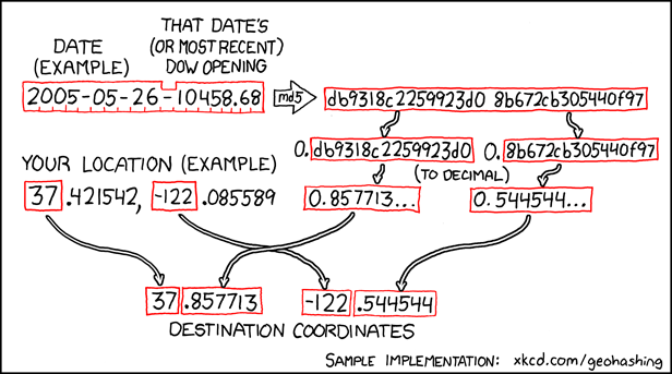
I keep my life pretty busy and don’t get as much “outside” as I’d like, but when I do I like to get out on an occasional geohashing expedition (like these ones). I (somewhat badly) explained geohashing in the vlog attached to my expedition 2018-08-07 51 -1, but the short version is this: an xkcd comic proposed an formula to use a stock market index to generate a pair of random coordinates, impossible to predict in advance, for each date. Those coordinates are (broadly) repeated for each degree of latitude and longitude throughout the planet, and your challenge is to get to them and discover what’s there. So it’s like geocaching, except you don’t get to find anything at the end and there’s no guarantee that the destination is even remotely accessible. I love it.

xkcd #426: Geohashing
My favourite kind of random pointlessness is summarised by this algorithm.

Most geohashers used to use a MediaWiki-powered website to coordinate their efforts and share their stories, until a different application on the server where it resided got hacked and the wiki got taken down as a precaution. That was last September, and the community became somewhat “lost” this winter as a result. It didn’t stop us ‘hashing, of course: the algorithm’s open-source and so are many of its implementations, so I was able to sink into a disgusting hole in November, for example. But we’d lost the digital “village square” of our community.

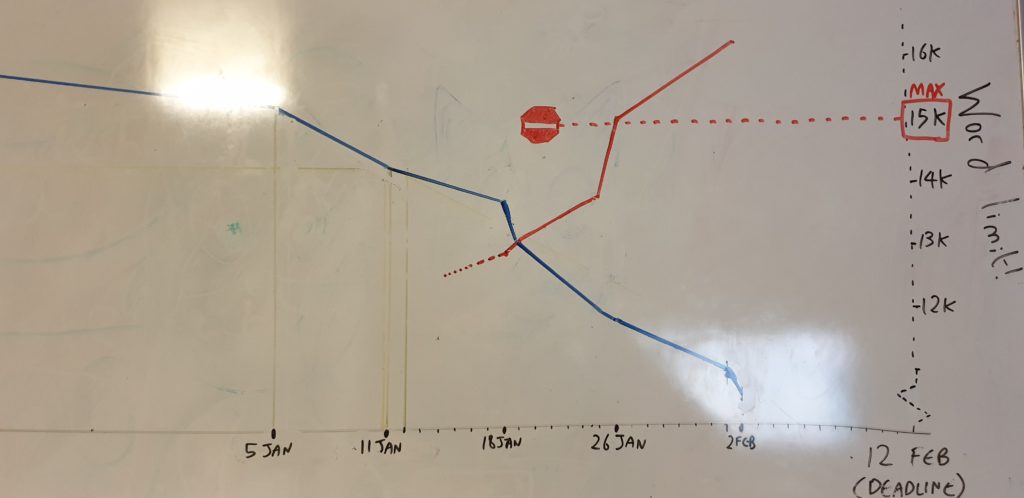
Graph of Dan's dissertation progress as the deadline creeps closer
My dissertation “burndown” is characterised on my whiteboard by two variables: outstanding issues (blue) and wordcount (red). There are… a few problems.

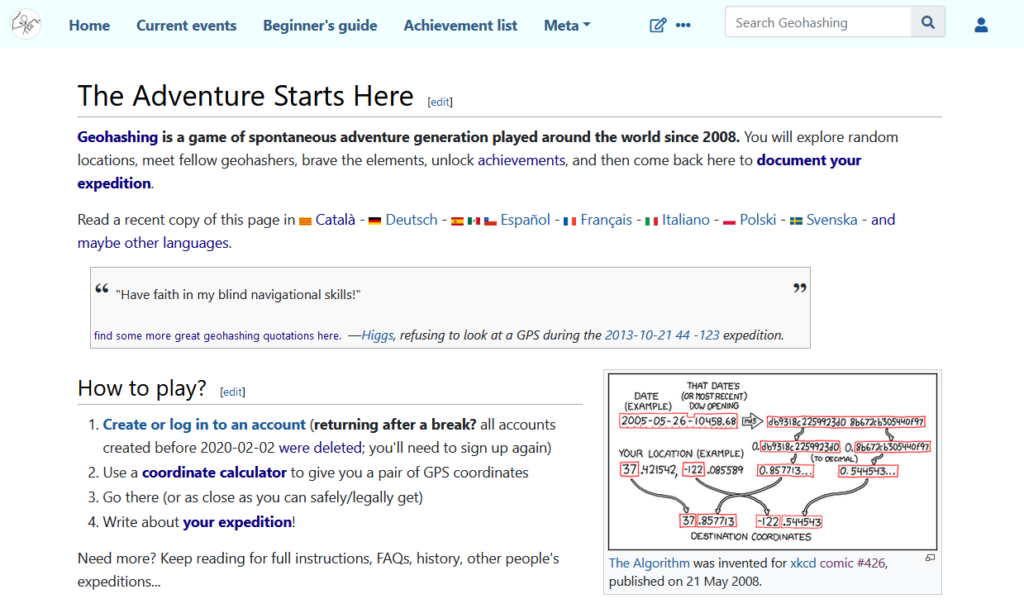
So I emailed Davean, who does techy things for xkcd, and said that I’d like to take over the Geohashing wiki but that I’d first like (a) his or Randall’s blessing to do so, and ideally (b) a backup of the pages of the site as it last-stood. Apparently I thought that my new job plus finishing my dissertation plus trying to move house plus all of the usual things I fill my time with wasn’t enough and I needed a mini side-project, because when I finally got the go-ahead at the end of last month I (re)launched geohashing.site. Take a look, if you like. If you’ve never been Geohashing before, there’s never been a more-obscure time to start!

geohashing.site homepage
My implementation of the site is mobile-friendly for the benefit of people who might want to use it while out in a muddy ditch. For example. Just hypothetically.

Luckily, it’s not been a significant time-sink for me: members of the geohashing community quickly stepped up to help me modernise content, fix bots, update hyperlinks and the like. I took the opportunity to fix a few things that had always bugged me about the old site, like the mobile-unfriendly interface and the inability to upload GPX files, and laid the groundwork to make bigger changes down the road (like changing the way that inline maps are displayed, a popular community request).

So yeah: Geohashing’s back, not that it ever went away, and I got to be part of the mission to make it so. I feel like I am, as geohashers say… out standing in my field.

× ×

Cool Thing Of The Day

Cool And Interesting Thing Of The Day To Do At The University Of Wales, Aberystwyth, #39:

Climb a nearby hill with the intention of finding a forest that you’ve heard is on the other side. Fail. Check maps to verify that the forest is there, and climb the hill again, looking for the forest. Fail. Check the maps, get somebody who’s been there already, and set off looking for them once more. Fail. Where in smeg’s name are the Cwm Woods??? How have they managed to evade me on three occassions, when I’ve had maps and experience on my side! Who knows? Who cares?

The ‘cool and interesting things’ were originally published to a location at which my “friends back home” could read them, during the first few months of my time at the University of Wales, Aberystwyth, which I started in September 1999. It proved to be particularly popular, and so now it is immortalised through the medium of my weblog.