Coming to the “start” of this loop having come from the “end” gave the geohound and I a perfect vantage point to sight this QEF. Now it’s time to find out how boggy the trail to #2 is!
If it’s as muddy as the one from #8 back to the village then we might need to make an alternative plan!
QEF for the geohound and I. My GPSr can’t connect to the Internet and I’m not retyping a URL into my phone so I can’t comment on the hint, but the cache itself is fine. SL, TFTC.
Coming from Leigh Loop 8 the geohound and I figured we had an easy and direct run here, but intolerable mud at the East end of the field path drove us out onto the road and back before
we could get to this cache. Even here, conditions were boggy and crossing the path to improve our certainty of our GPS coordinates was a drag! But we found it in the end pretty easily,
although its logbook is so wet as to almost be unsignable! TFTC.
Since our house flooded a few weeks ago we’ve been living out of a series of short holiday lets, waiting for the floors to dry out and the insurance company to assess the damage, before
we’ll hopefully be able to secure a slightly longer tenancy somewhere while repairs are done.
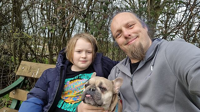
Right now we’re staying in New Yatt. I’ve cached a little around here before, but never this loop, so this morning the geopup and I came out for a walk and to begin this loop… at its
end!
After some initial difficulty getting a GPS fix we eventually found a good looking hiding place. Despite this being the first find out this cache and the terrible recent weather, the
cache and its log are in fine condition. SL, TFTC!
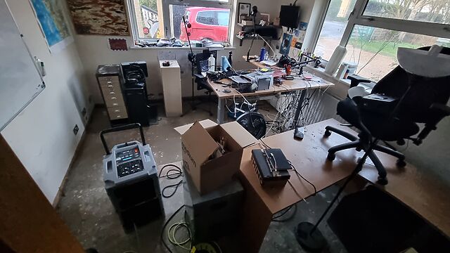
My regular home office of the last six years sits stripped-down, with no flooring, skirting boards, or power (with the exception of the specialised circuit powering an industrial
dehumidifier).
And man, a home insurance claim seems to be… slow. For instance, we originally couldn’t even get anybody out to visit us until F-day plus 10 (later improved to F-day plus
7). The insurance company can’t promise that they’ll confirm that they’ll “accept liability” (agree to start paying for anything) until possibly as late as F-day plus 17. Nobody will
check for structural damage until F-day plus 191.
Right now, though, we’re spending two weeks in this holiday let about half an hour’s drive from our house. It’s pretty nice, except that we have to commute over the ever-congested
single-lane Burford Bridge to get the kids to and from school every day2.
Some days it feels like being stuck in a nowhere-place… but simultaneously still having to make the regular everyday stuff keep ticking over. Visiting the house- currently stripped of
anything damp and full of drying equipment – feels like stepping onto another planet… or like one of those dreams where you’re somewhere familiar except it’s wrong somehow.
But spending time away from it, “as if” on holiday except-not, is weird too: like we’re accepting the ambiguity; leaning-in to limbo. Especially while we’re waiting for the insurance
company to do their initial things, it feels like life is both on hold, and not-allowed to be on hold.
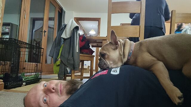
The dog gets it. I had to take her to the house for a while on Monday3 and she spent the whole time leaning against my feet for reassurance.
And I worry that by the time they’re committed to paying for us to stay somewhere else for at least half a year, they lose any incentive they might have to contract for speed. There’s
no hurry any more. We’re expected to just press pause on our home, but carry on with our lives regardless, pretending that everything’s normal.
So yeah, it’s a weird time.
Footnotes
1 I’m totally committed to this way of counting the progress, which I started on F-day plus 3. I get the feeling like it might be a worthwhile way of
keeping track of how long all of this takes.
2 Normally, the younger and older child are able to get to school on foot or via a bus
that stops virtually outside our house, each day, so an hour-plus round-trip to their schools and back up to twice a day is a bit of a drag! We’re managing to make it work with a
little creativity, but I wouldn’t want to make it a long-term plan!
3 And do some work from there, amidst the jet engine-like noise of the dehumidifiers!
Today was a long day. Between commuting (the kids to school from our distant flood-evacuation accommodation), work, childcare, insurance wrangling etc., I was pretty tired when I got
back “home”. So I came in and lay on the floor.
The family and I are staying in Lyneham for a couple of weeks following the flooding of our house (on the other side of Witney). This morning the younger geokid, the geopup, and I came
out for a walk to find this geocache as well as to explore Milton-under-Wychwood and tag some of the memorial benches for OpenBenches (1, 2, 3, 4).
We sat near the cache and the geokid immediately found it. Looks like we’re the second signatories of the New Year: somebody beat us to it on 5 Feb! TFTC.
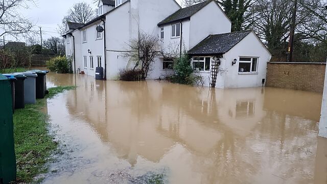
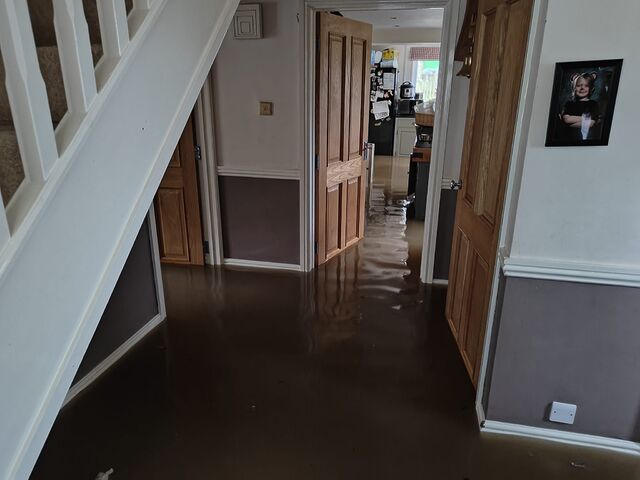
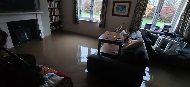
It feels inconceivable to me that we’re only at F-Day plus three; that is, three days since a flash flood rushed through the ground floor of our house and forced us to
evacuate. We’ve been able to visit since and start assessing the damage, but for now I figured that what you’d want would be the kinds of horrible pictures that make you say “wow; I’m
glad that didn’t happen to me”.
These pictures are all from F-Day itself (which happened to be Friday the 13th; delightful, eh?):
A particularly horrifying moment was when the seals on the patio doors gave way and the dining room began to flood, and we had to pivot to laying sandbags to protect the kitchen from
the dining room rather than to protect the house as a whole. (Eventually, every ground floor room would be affected.)
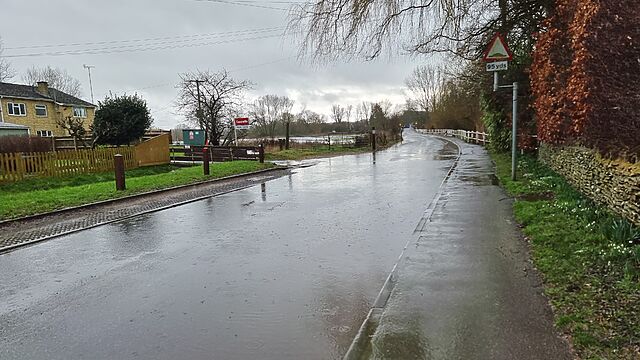
The water came in so quickly! An hour earlier, a deliveryperson had to wade carefully through a puddle to reach our front door. But by this point, the entire ground floor was under a
foot of dirty water.
It’s heartbreaking to see a house that you love and cherish as it starts to look like a scene from Titanic.
Soon enough we had to pivot from trying to hold back the waters to trying to save what we could. By the time the water level reached the air bricks and vents, we were having to make
split-second choices about what we had time to save.
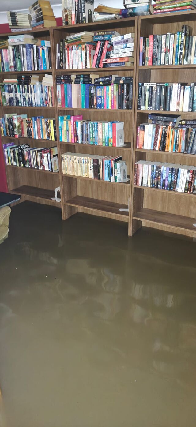
Not all of the books made it, but most of them did.
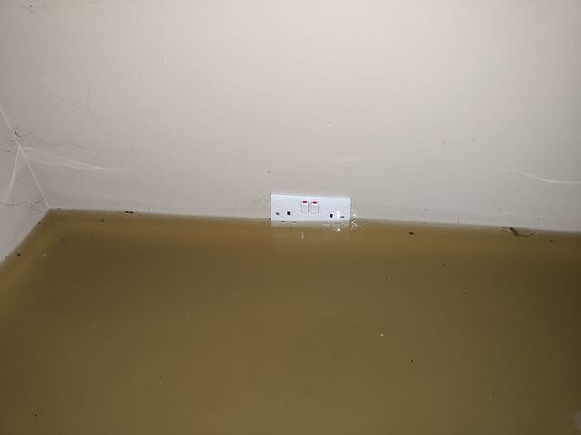
The fire brigade wisely had us switch off our electricity supply before the first row of sockets went underwater.
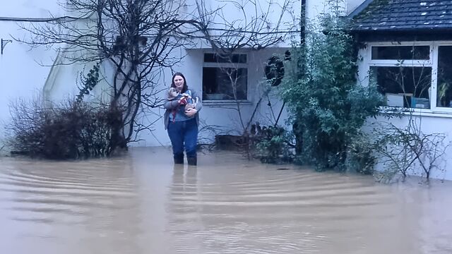
The dog was incredibly brave; retreating slowly up the stairs (while barking at the rising water!). But eventually she, too, required rescue.
In one of the few moment of levity, Ruth got to ‘play firefighter’ by carrying the poor pupper out of the building. By this point, the water depth was taller than the dog is.
We’ve had a few nights in Premier Inns, but it’s a new week and it’s time to hassle the insurance company to come and have a look around. And then, maybe, we can start working out where
we’ll live so the repair work can start.
One last cache on this afternoon’s walk before I had to take the geopup off for a doggy bath! We tried a couple of obvious hosts near the GZ before expanding our search and quickly
finding its hidey-hole. TFTC!
Walking backwards and forwards past the GZ eventually enabled the geopup and I to spot this very-visible but high-up cache. Soon it was retrieved, the log signed, and returned. Logbook
is very full; I had to just initial it.
The dog’s walk needed extending to make sure she’s well worn-out and not too-excited for some guests we’re having over this evening, so she and I came and parked on Dry Lane
(ironically-named, it seems, as the road was flooded) and walked down to try to find this cache. Unfortunately we weren’t able to find it, this time, but we’ll try again next time we’re
in the vicinity.
The geohound and I walked over from Catbrook this morning “the long way” – over the hill and woods, finding a couple of caches along the way – to this cache.
From both the cache type and my GPSr’s map data I fully expected to find a post box here alongside the (decrepit) red phone box, but it’s nowhere to be seen! Has it perhaps been
removed?
The dog and I spent a little while looking for the promised postbox, without success.
In any case, the hint reassured me that I was in the right place and my geosense told me where to look. A disappointingly tiny cache container (where a larger one could have probably
been placed) was soon found, caked in mud, and replaced as-found.
The geopup and I absolutely chose the right time to come up here on this wintery morning. The sun’s ascent over the valley whenever we escape the cover of the woods is absolutely
spectacular.
Happy New Year! The geopup and I, on holiday from West Oxfordshire and staying nearby, came out for a morning walk in the ice and snow today.
Our little Frenchie’s tiny legs made the work of climbing the stiles on this path a little challenging, but with persistence we were treated to a wonderful view of the sun broaching the
horizon over the valley at the North end of School Wood.
Soon the cairn was in sight, and what a brilliant spot for a cache! Signed log, and dropped a travel bug that’s come
all the way from Texas to continue its journey. FP awarded for bringing us out this way.