There’s a YouTube video from 2014 simply titled “Batman Suit-up Compilation.” As that description suggests, the 106-second clip, which has received approximately 1.86 million views,
is a highlight reel of different times in Batman movies in which the Caped Crusader dons his Batsuit.
It’s a fairly innocuous video, but it’s generated more than 550 comments. And the first responder basically sums up the discussion that continues down the rest of the page: “Was there
any point of showing Batman’s ass? Furthermore, why were Bats and Robin wearing codpieces? ”
My original plan to divert to the 2018-08-23 51 -1 hashpoint during my planned journey North-to-South along almost the entire length of the 51 -1 graticule was ruined somewhat by the
hashpoint turning out be farther North than my starting point! So I changed plans and overshot my destination in order to visit the 50 -1 hashpoint, instead (and find a couple of
geocaches on the way). Here’s how that went.
I’d originally planned on heading to 2018-08-23 51 -1 because I anticipated that it’d be on or
near my route travelling South along almost the entire length of the 51 -1 graticule, but I didn’t bargain on such a Northerly hashpoint so I’ve changed plans and am now aiming to get
to this one some time in the morning (I’m hoping to be in Winchester by lunch).
Expedition
The full story’s in vlog format, but here’s the summary:
Wasn’t originally planning to come to this graticule but instead was going to go to the 51 -1 graticule where I live ([2018-08-23 51 -1 see here]): I was going to be driving almost the entire length of 51 -1 on a journey from
Oxford to Winchester anyway, so I figured it’d be easy to divert to any hashpoint. But when the Dow numbers came out, it turned out that the hashpoints in this quadrant of the Earth are
all in the North-East corner, and so my journey would be in the opposite direction. Oh no! So instead I decided to “overshoot” and go for this graticule instead, and thus (if
successful) expand my Minesweeper Achievement level.
Hashpoint deep in woodland in the beautiful South Downs National Park.
Parked at The Sustainability Centre (and later made a donation via their website in thanks for
the use of their car park despite not using their other facilities) and walked initially through woodland they manage and use for natural burials: this was really cool – I’ve always
been a fan of body disposal in a low-environmental-impact, no-permanent-markers kind-of way, so I’m going to look more into what they offer. I was really interested to see that many
families had left “named” bird nesting boxes in memory of their loved ones, which is awesome too.
Found geocache GC2X5BJ just outside the burial area and close to a point that gave me a great view across a
valley towards the woods in which I believed I’d find the hashpoint.
Had to go some way off track to get to the hashpoint, but discovered a network of old, overgrown, long-abandoned (and not on any map I can find) trails in-between the thicket. In
fact, the hashpoint eventually turned out to be on the edge of such a track, which I was able to follow to help me find my way back to a road.
Found a sign pointing to “Droxford”. Oxford is so-named because its location coincides with the most-downstream point on the Thames at which it’s possible to ford the river
while driving cattle (i.e. “ox ford”) – incidentally, I’m told, the ford was at the point that Folly Bridge now stands. But what’s the etymology of Droxford, I wonder. What the hell is
a drox???
On the way back, diverted by geocache GC5P5KN and
found it: this was a great cache with the best-made
variant of the particular kind of container it used that I’ve ever seen.
Update: A little research later, it seems that the “ox” in each of Oxford and Droxford have completely different etymological roots! Droxford is derived from an ancient
name for the area from some time prior to the Middle Ages: Drocenesforda. “Drocen” means “dry”: the name means “dry ford”. The River Meon, which flows through the area, flows shallow
over a chalky bed and is easily forded in many places, as these motorcyclists show. The
things you learn!
It’s been a long time since I’ve seen a geocache hidden this way: FP for that alone! A lovely spot to drop in on in my way back from a successful hike to the (not too far away) 2018-08-23 50 -1 geohashing hashpoint this morning.
An easy find while taking a shortcut through the woods on my way to the 2018-08-23 50 -1 geohashing hashpoint (an
expedition that was eventually successful, though not without its challenges)! Container was exposed so I placed nearby stick on top of it to better conceal it. TFTC!
Better than your usual services cache-and-dash, I really appreciated that this cache took me away from the service station and along up a delightful little bridleway, this morning, not
to mention the decent-sized container!
I’m on my way down the A34 from Oxford in an expedition to the 2018-08-23 50 – 1 geohashpoint, before doubling back to
my actual destination of Winchester. With this cache, you not only gave me a welcome break, but also an excuse to stop and eat breakfast. TFTC!
I’m keen to get to level 2 of the Minesweeper Geohash achievement, and this
far-South-of-graticule hashpoint represents an opportunity to achieve that. I’ll be at work during the day, but – energy levels permitting after what’ll have been a long day! – I’ll
find a way to get up here and see if I can get to the hashpoint, aiming to arrive probably around 18:30.
Expedition
It had been a long day at work, but it looked to be a beautiful evening and I promised myself a pub dinner if I made it to the hashpoint, so I set out by car and by foot to East
Adderbury, the village nearest to the hashpoint. The village itself is stunning: lots of old stone buildings, a very traditional bridge, and beautiful green spaces. I spotted not one
but two candidate pubs (The Red Lion and The Coach & Horses) as I passed through the village, which was a reassuring start, and then pressed on
down a lane which quickly became a narrow trail, waving to some cows along the way (why do I always seem to meet cattle on my hashing adventures?).
The trail was full of blackberries so I wasn’t short of a snack, but it soon became clear that it wouldn’t get me any closer than 35m to the hashpoint. I returned to the entrance to the
cows’ field and, hopping a stile, crossed it. The cows looked puzzled as I paced around, getting to ground zero, but didn’t object. After shooting the traditional silly grin, I turned
tail and headed back into the village and to the Coach & Horses, which proved to be the very essence of a British village pub: a husband and wife couple running it, dogs everywhere, a
jar of pickled onions behind the bar, and more beers than you can shake a stick at.
I did enjoy a rather unusual conversation at the bar, though –
Me: Can I get a ham, egg, and chips please. And a pint of bitter shandy.
Barman: One egg or two?
Me: Oh! Two, please.
Barman:(Pause) We haven't got any eggs.
Me: Uhh. Okay; no eggs then.
Barman's wife: We've got one egg.
Barman: We've got one egg.
Me: I'll have one egg, then.
(I go and sit outside; after a while, my meal arrives. There are two eggs.)Barman's wife: I found another egg.
Me: ...
The Coach and Horses, The Green, Adderbury, Banbury OX17 3ND, United Kingdom.
Rating: ⭐⭐⭐⭐
Good food at spectacular prices. Friendly staff and free WiFi. A serendipitous find as I was exploring the village on my way back from a geohashing expedition: I’d certainly come back
if I find myself in this neck of the woods again.
Earlier this year, 2 friends and I decided to take on a hitch-hiking challenge to raise money for a charity called ‘The Campaign Against Living Miserably’. Last Friday Magnus, Sergio
and I set off from Brick Lane with the intention of reaching the town of ‘Twatt’ on the Archipelago of Orkney – we gave ourselves…
An especially-good post by Robin as part of his 52 Reflect series in which (among other adventures), he… hitches a lift on an
aeroplane! Well-worth reading!
Earlier this year I found a mystery cable. But today, I’ve got an even bigger mystery. What the hell is this?
It’s a… thing?
I found it in a meeting room at work, tucked away in a corner. Aside from the power cord, there are no obvious interfaces to it.
There are two keyhole-shaped “buttons” which can be pressed down about 2cm and which spring back up (except when they jam, but I think they’re not supposed to).
My best bet is that it’s some kind of induction-based charger? I imagine some kind of device like a radio microphone or walkie-talkie that can be pushed-in to these holes and the button
“spring” is just about closing the hole when it’s not in use. But the box is old, based on the style of plug, cable, and general griminess of the hardware… not to mention that
it’s got a stack of PAT test stickers going back at least 11 years.
No real markings anywhere on it: there’s a small hole in the (metal) base and PAT test stickers.
I’ve plugged it in and tried “pressing” the buttons but it doesn’t appear to do anything, which supports my “induction charger” hypothesis. But what does it charge? I must
know!
Edit:The only Electrak I can find make lighting control systems. Could it be
something to do with lighting control? I can’t find anything that looks like this on their website, though.
The plugs apparently look something like this, although I can’t find any here.
Edit 3: Hang on a minute… the most-recent PAT test sticker indicates that it was tested in… November 2019. Now my working hypothesis is that this is some kind
of power supply system for a time machine we haven’t yet built. I’ve asked a number of colleagues what it’s for (i.e. what plugs into it) and nobody seems to have a clue.
For those that don’t know, the skinny version is this: in May 2008 an XKCD comic was published proposing (or at least joking about) a new game with a
name reminiscient of geocaching. To play the game, participants use a mathematical hashing function on the current date
and the most recent Dow Jones Industrial Average opening value to generate sets of random coordinates around the
globe and then try to find their way to them, hopefully experiencing adventures along the way. The nature of stock markets and hashing functions means that the coordinates for any given
day are effectively random and impossible to predict (far) in advance, so it’s sometimes described as a spontaneous adventure generator.
The XKCD comic that started it all.
Recently, I found myself wondering about how much of a disadvantage players are at if they live in very “wet” graticules. Residents of the Channel Islands graticule (49 -2), for example, are confined to two land masses surrounded entirely by water. And while it’s
true that water hashpoints can be visited if you’re determined enough, it’s still got to be considered to be
playing at a disadvantage compared to those of us lucky ones in landlocked graticules like mine (51 -1).
And because I’m me and so can’t comfortably leave a question unanswered, I wrote a program to try to answer it! It’s among the hackiest, dirtiest software solutions I’ve ever written,
so if it works for you then it’s a flipping miracle. What it does is:
Determines which OpenStreetMap tiles (the image files served to your browser when you use OpenStreetMap) cover the graticule in question, and downloads them.
Extracts information about the colour of each pixel in each tile.
Counts the proportion of “water blue” pixels to other pixels (this isn’t perfect, because it trips over things like ferry lines on the map as being “not water”, especially at low
zoom-levels).
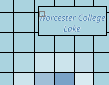
Some parts of Worcester College Lake are identified as “not water” on account of the text overlay.
I mentioned it was hacky, right?
You can try it for yourself, if you’d like. You’ll need NodeJS, wget, wc, and ImageMagick – all pretty standard or easy-to-get things on a typical Linux box. Run with
node geohash-pcwater.js 51 -1, where 51 -1 is the identifier for the graticule you’re interested in. And in case you’re interested – the Swindon graticule (where I live) is
about 0.68% water, but the Channel Islands graticule is closer to 93.13% water. That’s no small disadvantage: sorry, Channel Islands geohashers!
Update 2018-08-22: discovered some prior art that takes a
somewhat-similar approach.
A letter I got recently and a question I was asked in another forum really got me to thinking. The question was: How did you come to realize that poly-amorous relationships were
right for you? Now …
A letter I got recently and a question I was asked in another forum really got me to thinking. The question was: How did you come to realize that poly-amorous relationships were right
for you? Now that you live this lifestyle, do you think that it’s for everyone, or more “natural” than monogamy? I answered:…
I was pleased to see that one of my favourite poly bloggers came out and said what I’ve always argued: that polyamory might well not be for everyone! I’m a big fan of the idea
that everybody can learn some useful relationship-negotiation and communication skills from studying the practice of polyamory, but I’m certainly not suggesting that my lifestyle ought
to be everybody else’s!
Oh my Goat! We just finished reading this awesome pick-a-path story that helps children learn the power of kindness. Have a go… #OatTheGoat
Discovered this fun interactive storybook; it tells the tale of a goat called Oat who endeavours to climb a mountain (making friends along the way). At a few points, it presents as a
“choose your own adventure”-style book (although the forks are artificial and making the “wrong” choice immediately returns you the previous page), but it still does a reasonable job at
looking at issues of bullying and diversity.
If you happened to flip through a PC gaming magazine in the late 1980s or early 1990s, you would’ve probably seen an ad for a game called Leisure
Suit Larry, or one of its many sequels. It was a graphic adventure game first released in 1987 with the primary goal of helping its protagonist get laid. Since most games then
leaned heavily into cartoon violence, Larry’s sexual innuendo stood out. To young boys at the time, it had the mystique of a shrink-wrapped Playboy in a convenience store.