I’m in Manchester for the day for a social gathering related to a variety of the volunteering activities I’ve been involved with over the last, OMG-I’m-so-old, 26 years or so. After my
train arrived I meandered via OK04B5 (nice to see the OC community alive and well here in Manchester!) to find myself
some lunch, then dropped by this cache on my way to our event venue.
The location was spot on and I saw the cache rightaway, but needed to wait for a couple of Deliveroo drivers to finish chatting and leave before I could get to the container itself.
Soon in hand, though. TFTC!
I’m in Manchester for a volunteering-adjacent social event and, not often seeing OpenCaches pop up on my radar, visited this spot on my way from the station to the venue. So beautiful
to see Manchester acknowledge its part in queer history, and a beautiful memorial to everybody who has died as a result of the AIDS pandemic. TFTC!
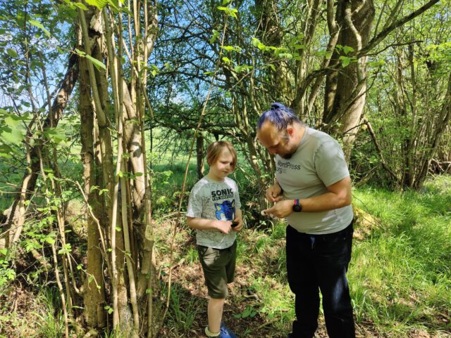
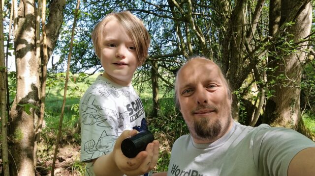
I’m spending the weekend volunteering for a nonprofit I founded (it’s almost as old as geocaching, at 23). We’re staying in a hotel at N 52°
36.184′ W 001° 53.869′. I’ve also gotten out to find a couple of localgeocaches.
But guess which room number the hotel have given me…
Found following a short hunt and a brief rummage after walking up the nearby footpath, with the help of a previous log which talked about crossing a fence (which I didn’t need to do, having come up
the correct way in the first place).
Some fellow volunteers and I are meeting at a hotel to the West of here for a weekend of making
software to help charities. When we meet up, I have a tradition of getting up early and finding a geocache or two before breakfast. Having exhausted the very-local supply of caches
on previous visits, and not wishing to miss out on the tradition on this, geocaching’s 25th birthday, I decided it was time to come further afield (and to finally solve this puzzle!…
I’m still stumped by its sibling, though!).
Nice container. Log slightly damp, but still usable. TFTC, and FP awarded for the enjoyable (once I spotted a pattern!) puzzle.
Woke early, as usual, for the first day of a weekend of volunteering, while staying at nearby Fairlawns. I’ve already tapped out the most-local caches to that hotel on previous stays, so for this morning’s walk I came further afield to find
this (and one of the two puzzle caches not too far away; that’s next, hopefully!)
This nice (topical!) container was an easy find once I poked my head into the right place. TFTC!
Saw GCB61ZC “Mossy” appear yesterday, but I’d already had an Easter Sunday beer or two and couldn’t drive out here… in fact, I
realised, I probably wasn’t in a state to cycle out here either and so I resolved that I’d come out the following morning – that is, today – by car and give the dog a walk while finding
GL1E5FYX0 and its year-older sibling GCAR5HV “Ivy”.
But early this morning the dog had been poorly and was still needing to relieve herself with little to no notice, so I didn’t want to risk putting her in the car! Though… I did want to
keep her outdoors! It was time for a change in plan: instead of driving to near the cache then taking a walk… we’d attempt the whole thing on foot, perhaps taking the opportunity to
explore some of the back footpaths that we’d not yet had a chance to try. We’d now missed
our chance for the FTF at “Mossy”, but we could still enjoy a walk (and hopefully give the dog a chance to feel better).
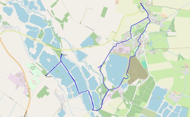
We cut through fields at Sutton, past The Fox and Blackditch Farm, to brush against the side of Lakeside Industrial Estate and head down Dix Pit. After a brief pause to report fly
tipping at 51.745311, -1.412871 (why would anybody fly tip literally just down the road from the recycling centre? it boggles my mind), we decided to duck off the road and take the
parallel public footpath for a bit (OSM Way #204829432, trailhead 51.742330, -1.416563).
To our surprise, the public footpath was fenced off. I thought we might instead be able to take the track to the West and intersect with the nearby bridleway (OSM Way #1129092587) but it was marked as private, so we continued down Dix Pit. How DOES one get to that bridleway, I wondered? Just
out of curiosity we tried to join it via the footpath (OSM Way #1129092588) at 51.737047, -1.412766, but it, too, lacked a
usable gate (and looked severely overgrown!), although the public footpath signs within the mess were still visible. I suspect that this public footpath has been long neglected by the
landowner and is quickly becoming lost to the world.
Instead, then, we passed Cutmill Farm and took the footpath through the woods that straddle the boundary line between Stanton Harcourt and Standlake, crossing the Windrush at a bridge
that seemed to serve as the meeting point for a great multitude of dog walkers. My geopup, who’s not always the friendliest with new dogs, enjoyed greeting a few of them while warily
watching the others.
We looped around Oxlease Lake in a clockwise direction, crossed Standlake Brook (the dog was very keen to get a drink of water, and in trying to do so made herself exceptionally muddy),
and began working our way up the long driveway past the swimmers and anglers and sailors assembling and preparing for their bank holiday activities. I recalled that I’d been up this way about a year ago to find GCAQJN1 “Hardwick park 1”: I got the FTF on that, but it proved to be a short-lived
cache, getting retired only three or four months later when park owners cut back the trees that had been its host. But I’d actually been here much earlier, too – over a decade ago –
long before I moved to the local area, to find the much-more long-lived GC1TPFY “Constellations 4”. Strange to hunt for
caches in places that I’ve walked past at least twice before, before those caches were hidden!
First up was “Mossy” (GCB61ZC). The dog – who was by now feeling herself again and happy to lead the way – struggled with the narrow kissing-gate to get onto the trail (she’s not so
bright and doesn’t understand that she needs to make room for me to join her before I can open the gate) but soon we were on the path. The hiding place leapt out at me and soon the
cache was in hand, the log signed (right behind Mad H@ter, whose Leafield series I was just attempting five days ago), and the cache returned to its hiding spot beneath its excellent
camoflage. I hope the container survives the winter rains!
Second was “Ivy” (GCAR5HV): a brief walk through the holiday park away (via a glance at the watersports centre, which by the looks of things have paddleboards for rent: I first tried
paddleboarding on the sea and figure it might be easier on a lake, so perhaps I’ll find an excuse to come down here and have a go at some point). The host was easy to find, but it took
some searching to put my hand on the container because I started at the “wrong” side. It looks like it’s had (unlogged?) maintenance done since BusyLittleGeo’s visit last week: the
cache was in perfect condition and the logbook was empty.
Now it was time to return home and give this happy (but mucky) dog a bath. We retraced our steps until Dix Pit, but then cut through the Devils’ Quoits and out through Hayfield Green to
return to Stanton Harcourt, and from there picked our way back through the fields at Sutton to return home.
Second time lucky! As the pup and I approached the GZ we found a strange handwritten note on the ground, and, having not seen it on the way up, figured that it must belong to a woman
we’d passed a little while ago. So we doubled back and returned it to her – turns out it was her shopping list – and chatted about the beautiful bluebells (which is what she’d come out
to see) before parting ways and returning to this cache.
At long last, finally uninterrupted, it was a pretty easy find in just the second place I looked. TFTC!
(And with that, we should get back home so this pupper can have a nap! Hopefully we can return and do the rest of the series sometime soon!)
Success on the second attempt. The geohound “guarded” the buggy-trapping ruts while I searched three
different hosts before finding the container. TFTC!
I let the man with the kids and the dog ahead of me so I’d be able to mount searches without having to stop and separate dogs, but I caught up with him literally at this cache! His
buggy (which carried two of the kids – the third was strapped to his chest) had gotten stuck in a rut and he was busy extracting it.
So I skipped this one, for now, and tried to get some distance ahead of him to the next one: I can always try on the way back.
(I’ll kick myself if it turns out he’s geocaching, too!)
Coordinates seemed solid, hint item seemed clear, but a good feel around didn’t reveal anything to me except an alarming sign I had to walk past! (pictured)nnThen a man with kids and a
dog came along and we needed to keep moving. Not sure where this could be hidden that I didn’t already check!
An excellent container in a picturesque spot. FP awarded. The geopup didn’t want to come exploring off the path so I had to find this one by myself.
SL, TFTC.