I’m staying in a lodge in the Yorkshire Dales National Park to celebrate the eldest kid’s birthday and we’ve just received a huge dump of snow, overnight. What was grass is now a thick
white carpet of fresh powder. Sounds like a great birthday present for an excited kid I can just hear beginning to wake up…
An extended search over two visits today by the eldest child and I couldn’t reveal this one. Very frustrating, given that it’s clearly there somewhere (CO performed maintenance just
yesterday!). We’re staying in a cabin a little way downstream, so we might find another opportunity to search again tomorrow, weather-permitting. 🤞
QEF while stopped for a confort break on a long journey North from Oxford. The dog wanted to go with the others into the services, but had to stay outdoors with me and hunt for the
cache. Solid hint!
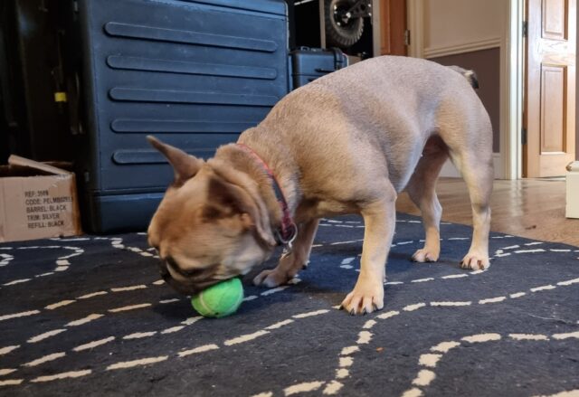
Our beloved-but-slightly-thick dog will sometimes consent to playing fetch, but one of her favourite games to play is My Ball. Which is a
bit like fetch, except that she won’t let go of the ball.
It’s not quite the same as tug-of-war, though. She doesn’t want you to pull the toy in a back-and-forth before, most-likely, giving up and letting her win1. Nor is My Ball a solo game: she’s not interested
in sitting and simply chewing the ball, like some dogs do.
I’d like to imagine the grunts and snorts she makes at about this moment actually translate to “My ball. Myyyy… ballll. Myyyyy ball! MY BALL! My… BALL!”
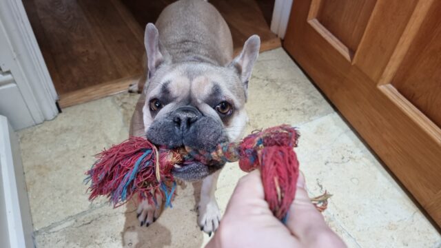
No, this is absolutely a participatory game. She’ll sit and whine for your attention to get you to come to another room. Or she’ll bring the toy in question (it doesn’t have to
be a ball) and place it gently on your foot to get your attention.
Your role in this game is to want the ball. So long as you’re showing that you want the ball – occasionally reaching down to take it only for her to snatch it away at
the last second, verbally asking if you can have it, or just looking enviously in its general direction – you’re playing your part in the game. Your presence and participation is
essential, even as your role is entirely ceremonial.
This might look like a game of tug-of-war, but you’ll note that my grip is just barely two-fingered. She’s not pulling, because she doesn’t need to unless I try to take the toy. This
is My Rope, she knows.
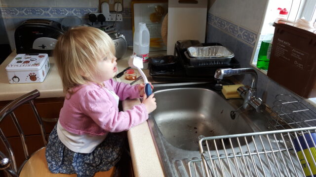
Playing it, I find myself reminded of playing with the kids when they were toddlers. The eldest in particular enjoyed spending countless hours playing make-believe games in which the
roles were tightly-scripted2. She’d tell me that, say, I was a talking badger or a grumpy
dragon or an injured patient but immediately shoot down any effort to role-play my assigned character, telling me that I was “doing it wrong” if I didn’t act in exactly the unspoken way
that she imagined my character ought to behave.
But the important thing to her was that I embodied the motivation that she assigned me. That I wanted the rabbits to stop digging too near to my burrow3 or the
princess to stay in her cage4 or to lie down in my hospital bed and await the doctor’s eventual arrival5.
Sometimes I didn’t need to do much, so long as I showed how I felt in the role I’d been assigned.
In this game, the chef was “making soup” (in the sink, apparently) and my job was to “want the soup”.
Somebody with much more acting experience and/or a deeper academic comprehension of the performing arts is going to appear in the comments and tell me why this is, probably.
But I guess what I mean to say is that playing with my dog sometimes reminds me of playing with a toddler. Which, just sometimes, I miss.
Footnotes
1 Alternatively, tug-of-war can see the human “win” and then throw the toy, leading to a
game of fetch after all.
3 “Grr, those pesky rabbits are stopping me sleeping.”
4 “I’ll just contentedly sit on my pile of treasure, I guess?”
5 Playing at being an injured patient was perhaps one of my favourite roles, especially
after a night in which the little tyke had woken me a dozen times and yet still had some kind of tiny-human morning-zoomies. On at least one such occasion I’m pretty sure I actually
fell asleep while the “doctor” finished her rounds of all the soft toys whose triage apparently put them ahead of me in the pecking order. Similarly, I always loved it
when the kids’ games included a “naptime” component.
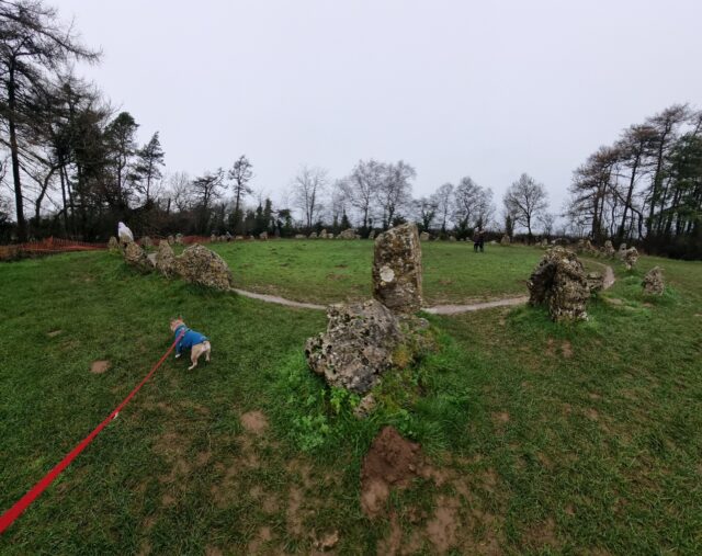
Our family tradition on New Year’s Day is to go to the Rollright Stones. Legend has it that you can’t count the standing stones and get the same answer twice.
This year the younger child counted 37, the elder 67… so wide a difference that you can see how one might ascribe a mystical reason!
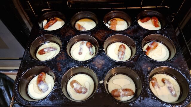
This evening I used leftover cocktail sausages to make teeny-tiny toads-in-the-hole (my kids say they should be called
frogs-in-the-dip).
It worked out pretty well.
Micro-recipe:
1. Bake cocktail sausages (or veggie sausages, pictured) until barely done.
2. Meanwhile, make a batter (per every 6 sausages: use 50ml milk, 50g plain flour, 1 egg, pinch of salt).
3. Remove sausages from oven, then turn up to 220C.
4. Put a teaspoon of a high-temperature oil (e.g. vegetable, sunflower) into each pit of a cake/muffin tin, return to oven until almost at smoke point.
5. Add a sausage or two to each pit and return to the oven for a couple of minutes to come back up to temperature.
6. Add batter to each pit. It ought to sizzle when it hits the oil, if it’s hot enough. Return to the oven.
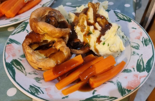
7. Remove when puffed-up and crisp. Serve with gravy and your favourite comfort food accompaniments.
Got the ratio of chipolatas to bacon wrong for your Christmas pigs-in-blankets and now have more cocktail sausages than you know what to do with? No, just me?
Here’s my planned solution, anyway – teeny tiny toads-in-the-hole! (Toad-in-the-holes?) Let’s see how it works out…
On a midnight train back from a London theatre trip, somehow the 8-year-old is still awake (and reading comics to me!); the 10-year-old is understandably wiped-out.
Our family Christmas Eve tradition, which we absolutely stole from Icelandic traditions (cultural appropriation? I’m not sure…) via some newspaper article we saw years ago, is a book
exchange.
verybody gives each other person a book,then we sit around and read until people retire to bed (first the kids, then – eventually – the adults).
Christmas Jumper Day at school, and I’m continuing my never-ending effort never to rest on my laurels, proving myself time and again worthy of my title of Most Embarrassing Parent.
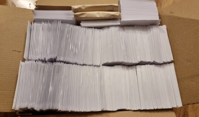
Today I put 550 Christmas cards into envelopes, sealed them, put address labels on them, and stamped them.
Because these were the “lick and stick” kind of envelopes rather than a self-sealing variety, I’ve been unable to taste anything except glue ever since.
Yesterday, I fulfilled the primary Three Rings objective I set for myself when I kicked off my sabbatical
twelve weeks ago and migrated the entire application to a new hosting provider (making a stack of related improvements along the way).
Months prior, I was comparing different providers and their relative merits, making sure that our (quirky and specific) needs could be met. Weeks beforehand, I was running a “dry run”
every four or five days, streamlining the process of moving the ~450GB1
of live data while minimising downtime. Days before the event felt like the countdown for a rocket launch, with final preparations underway: reducing DNS time-to-lives, ensuring users
knew about our downtime window, and generally fitting in a little time to panic.
I made reference on International Volunteer Day to how we needed to configure logrotate. When you’re building architecture for a system as gnarly as Three Rings, there’s
about a billion tools that need such careful tweaking2.
The whole operation was amazingly successful. We’d announced an at-risk period of up to six hours and I was anticipating it taking three… but the whole thing was completed within
a downtime window of just two and a half hours. And I fully credit all of the preparation time. It turns out that “measure twice, cut once” is a sensible strategy3.
It’s challenging to pull off a “big”, intensive operation like this in an entirely voluntary operation. I’m not saying I couldn’t have done it were I not on sabbatical, but
it’d certainly have been harder and riskier.
1Three Rings‘ user data is represented by a little under 70GB of MariaDB
databases plus about 380GB of organisational storage: volunteer photos, files, email attachments, and the like. Certainly not massive by comparison to, say, social media sites, search
engines, and larger eCommerce platforms… but large enough that moving it takes a little planning!
2 Okay, a billion tools to configure? That’s an exaggeration. Especially
now: since the architectural changes I’ve put in place this week, for example, production app server builds of Three Rings no require a custom-compiled build of Nginx (yes,
this really was something we used to need).