…
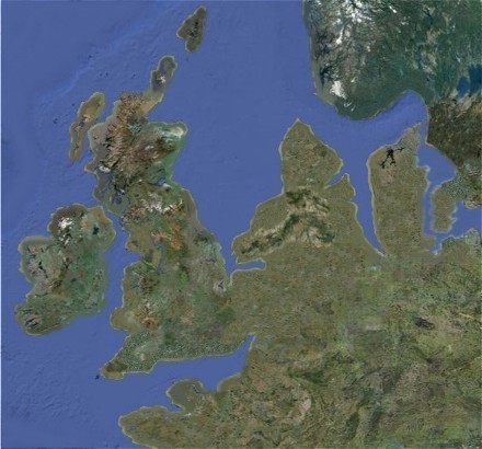
As well additional land around our familiar coastlines, the lower sea level reveals a low lying 9,000 square mile landmass called Doggerland – named after Dogger Bank, the large sandbank which currently sits in a shallow area of the North Sea off the east coast of England (dogger being an old Dutch word for fishing boat).
Doggerland had a rich landscape of hills, rivers and lakes and a coastline comprising lagoons, marshes and beaches. It had woodlands of oak, elm, birch, willow, alder, hazel and pine. It was home to horses, aurochs, deer, elks and wild pigs. Waterfowl, otters and beavers abounded in wetland areas and the seas, lakes and rivers teemed with fish. It was probably the richest hunting and fishing ground in Europe at the time and had an important influence on the course of prehistory in northwestern Europe as maritime and river-based societies adapted to this environment.
…
I love a bit of alternative history fiction, and this is a big one, going all the way back to prehistoric times. What if the period of global warming that took place thousands of years ago, “sinking” Doggerland and separating the formerly-connected British Isles from one another and from the European mainland? The potential impact is massive, affecting geography, history, and politics indefinitely, and it’s fun to think – and read – about.
