Over the last six years I’ve been on a handful of geohashing expeditions, setting out to functionally-random GPS coordinates to see if I can get there, and documenting what I find when I do. The comic that inspired the sport was already six years old by the time I embarked on my first outing, and I’m far from the most-active member of the ‘hasher community, but I’ve a certain closeness to them as a result of my work to resurrect and host the “official” website. Either way: I love the sport.
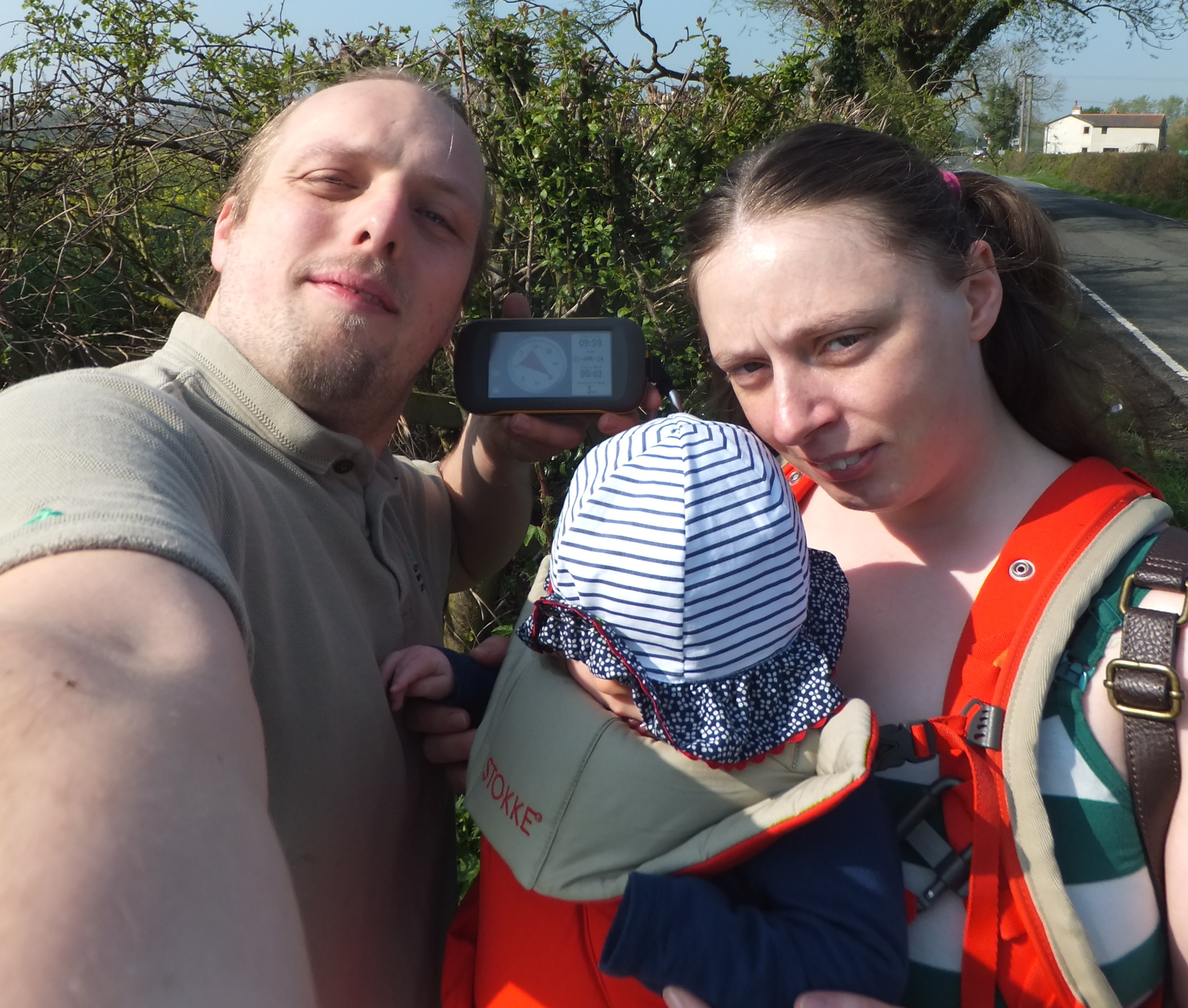
I even managed to drag-along Ruth and Annabel to a hashpoint (2014-04-21 51 -1) once.But even when I’ve not been ‘hashing, it occurs to me that I’ve been tracking my location a lot. Three mechanisms in particular dominate:
Google’s somewhat-invasive monitoring of my phones’ locations (which can be exported via Google Takeout)
My personal GPSr logs (I carry the device moderately often, and it provides excellent precision)
The personal μlogger server I’ve been running for the last few years (it’s like Google’s system, but – y’know – self-hosted, tweakable, and less-creepy)
If I could mine all of that data, I might be able to answer the question… have I ever have accidentally visited a geohashpoint?
Let’s find out.
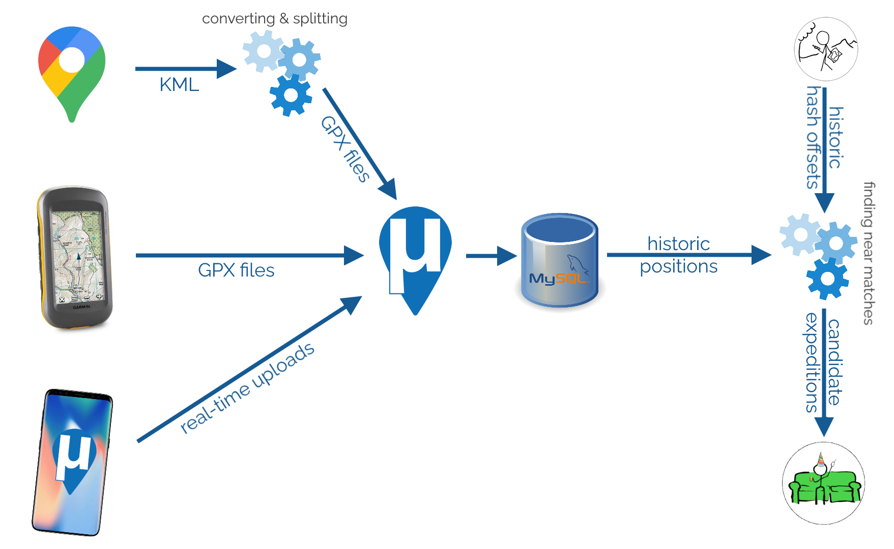
There’s a lot to my process, but it’s technically quite simple.Data mining my own movements
To begin with, I needed to get all of my data into μLogger. The Android app syncs to it automatically and uploading from my GPSr was simple. The data from Google Takeout was a little harder.
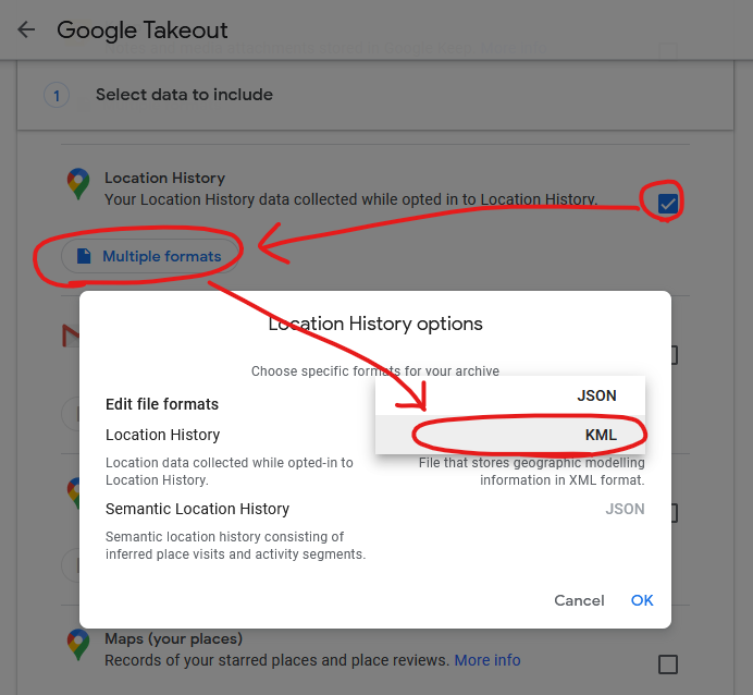
I found a setting in Google Takeout to export past location data in KML, rather than JSON, format. KML is understood by GPSBabel which can convert it into GPX. I can “cut up” the resulting GPX file using a little grep-fu (relevant xkcd?) to get month-long files and import them into μLogger. Easy!
It’s slightly hidden, but Google Takeout choose your geoposition output format (from a limited selection).Well.. μLogger’s web interface sometimes times-out if you upload enormous files like a whole month of Google Takeout logs. So instead I wrote a Nokogiri script to convert the GPX into SQL to inject directly into μLogger’s database.
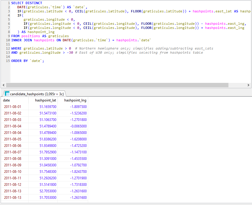
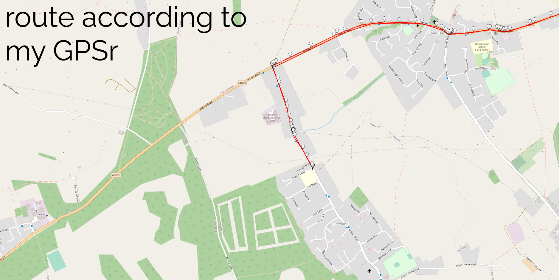
Next, I got a set of hashpoint offsets. I only had personal positional data going back to around 2010, so I didn’t need to accommodate for the pre-2008 absence of the 30W time zone rule. I’ve had only one trip to the Southern hemisphere in that period, and I checked that manually. A little rounding and grouping in SQL gave me each graticule I’d been in on every date. Unsurprisingly, I spend most of my time in the 51 -1 graticule. Adding (or subtracting, for the Western hemisphere) the offset provided the coordinates for each graticule that I visited for the date that I was in that graticule. Nice.
Preloading the offsets into a temporary table made light work of listing all the hashpoints in all the graticules I’d visited, by date. Note that some dates (e.g. 2011-08-04, above) saw me visit multiple graticules.The correct way to find the proximity of my positions to each geohashpoint is, of course, to use WGS84. That’s an easy thing to do if you’re using a database that supports it. My database… doesn’t. So I just used Pythagoras’ theorem to find positions I’d visited that were within 0.15° of a that day’s hashpoint.
Using Pythagoras for geopositional geometry is, of course, wrong. Why? Because the physical length of a “degree” varies dependent on latitude, and – more importantly – a degree of latitude is not the same distance as a degree of longitude. The ratio varies by latitude: only an idealised equatorial graticule would be square!
But for this case, I don’t care: the data’s going to be fuzzy and require some interpretation anyway. Not least because Google’s positioning has the tendency to, for example, spot a passing train’s WiFi and assume I’ve briefly teleported to Euston Station, which is apparently where Google thinks that hotspot “lives”.
I overlaid randomly-selected Google My Location and GPSr routes to ensure that they coincided, as an accuracy-test. It’s interesting to note that my GPSr points cluster when I was moving slower, suggesting it polls on a timer. Conversely Google’s points cluster when I was using data (can you see the bit where I used a chat app), suggesting that Google Location Services ramps up the accuracy and poll frequency when you’re actively using your device.I assumed that my algorithm would detect all of my actual geohash finds, and yes: all of these appeared as-expected in my results. This was a good confirmation that my approach worked.
And, crucially: about a dozen additional candidate points showed up in my search. Most of these – listed at the end of this post – were 50m+ away from the hashpoint and involved me driving or cycling past on a nearby road… but one hashpoint stuck out.
Hashing by accident
We all had our roles to play in our trip to Edinburgh. Tom… was our pack mule.In August 2015 we took a trip up to Edinburgh to see a play of Ruth‘s brother Robin‘s. I don’t remember much about the play because I was on keeping-the-toddler-entertained duty and so had to excuse myself pretty early on. After the play we drove South, dropping Tom off at Lanark station.
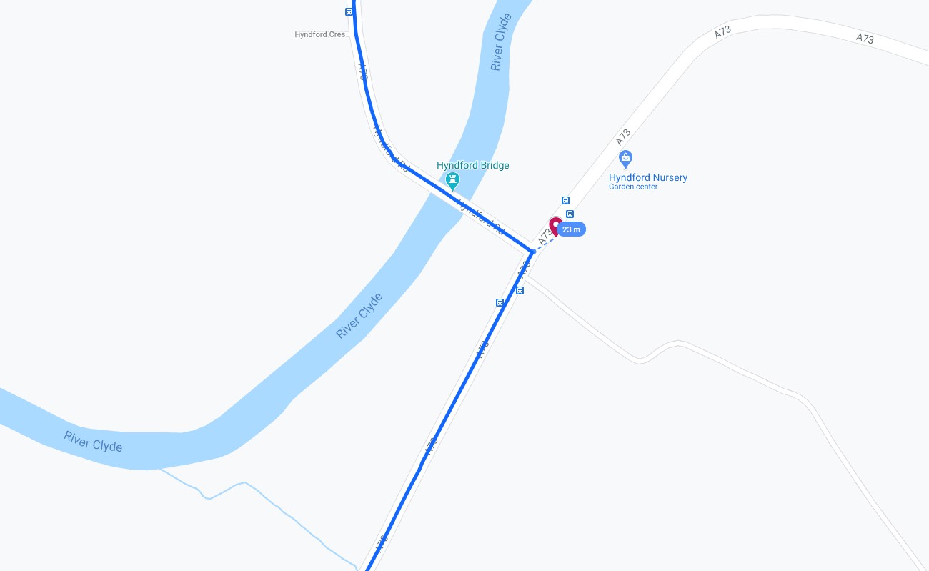
We exited Lanark via the Hyndford Bridge… which is – according to the map – tantalisingly-close to the 2015-08-22 55 -3 hashpoint: only about 23 metres away!
Google puts the centre of the road I drove down only 23m from the 2015-08-22 55 -3 hashpoint (of course, I was actually driving on the near side of the road and may have been closer still).That doesn’t feel quite close enough to justify retroactively claiming the geohash, tempting though it would be to use it as a vehicle to my easy geohash ribbon. Google doesn’t provide error bars for their exported location data so I can’t draw a circle of uncertainty, but it seems unlikely that I passed through this very close hashpoint.
Pity. But a fun exercise. This was the nearest of my near misses, but plenty more turned up in my search, too:
2013-09-28 54 -2 (9,000m)
Near a campsite on the River Eden. I drove past on the M6 with Ruth on the way to Loch Lomond for a mini-break to celebrate our sixth anniversary. I was never more than 9,000 metres from the hashpoint, but Google clearly had a moment when it couldn’t get good satellite signal and tries to trilaterate my position from cell masts and coincidentally guessed, for a few seconds, that I was much closer. There are a few such erroneous points in my data but they’re pretty obvious and easy to spot, so my manual filtering process caught them.
2019-09-13 52 -0 (719m)
A600, near Cardington Airstrip, south of Bedford. I drove past on the A421 on my way to Three Rings‘ “GDPR Camp”, which was more fun than it sounds, I promise.
2014-03-29 53 -1 (630m)
Spen Farm, near Bramham Interchange on the A1(M). I drove past while heading to the Nightline Association Conference to talk about Three Rings. Curiously, I came much closer to the hashpoint the previous week when I drove a neighbouring road on my way to York for my friend Matt’s wedding.
2020-05-06 51 -1 (346m)
Inside Kidlington Police Station! Short of getting arrested, I can’t imagine how I’d easily have gotten to this one, but it’s moot anyway because I didn’t try! I’d taken the day off work to help with child-wrangling (as our normal childcare provisions had been scrambled by COVID-19), and at some point during the day we took a walk and came somewhat near to the hashpoint.
2016-02-05 51 -1 (340m)
Garden of a house on The Moors, Kidlington. I drove past (twice) on my way to and from the kids’ old nursery. Bonus fact: the house directly opposite the one whose garden contained the hashpoint is a house that I looked at buying (and visited), once, but didn’t think it was worth the asking price.
2017-08-30 51 -1 (318m)
St. Frieswide Farm, between Oxford and Kidlington. I cycled past on Banbury Road twice – once on my way to and once on my way from work.
2015-01-25 51 -1 (314m)
Templar Road, Cutteslowe, Oxford. I’ve cycled and driven along this road many times, but on the day in question the closest I came was cycling past on nearby Banbury Road while on the way to work.
2018-01-28 51 -1 (198m)
Stratfield Brake, Kidlington. I took our youngest by bike trailer this morning to his Monkey Music class: normally at this point in history Ruth would have been the one to take him, but she had a work-related event that she couldn’t miss in the morning. I cycled right by the entrance to this nature reserve: it could have been an ideal location for a geohash!
2014-01-24 51 -1 (114m)
On the Marston Cyclepath. I used to cycle along this route on the way to and from work most days back when I lived in Marston, but by 2014 I lived in Kidlington and so I’d only cycle past the end of it. So it was that I cycled past the Linacre College of the path, around 114m away from the hashpoint, on this day.
2015-06-10 51 -1 (112m)
Meadow near Peartree Interchange, Oxford. I stopped at the filling station on the opposite side of the roundabout, presumably to refuel a car.
2020-02-27 51 -1 (70m)
This was a genuine attempt at a hashpoint that I failed to reach and was so sad about that I never bothered to finish writing up. The hashpoint was very close (but just out of sight of, it turns out) a geocache I’d hidden in the vicinity, and I was hopeful that I might be able to score the most-epic/demonstrable déjà vu/hash collision achievement ever, not least because I had pre-existing video evidence that I’d been at the coordinates before! Unfortunately it wasn’t to be: I had inadequate footwear for the heavy rains that had fallen in the days that preceded the expedition and I was in a hurry to get home, get changed, and go catch a train to go and see the Goo Goo Dolls in concert. So I gave up and quit the expedition. This turned out to be the right decision: going to the concert one of the last “normal” activities I got to do before the COVID-19 lockdown made everybody’s lives weird.
2014-05-23 51 -1 (61m)
White Way, Kidlington, near the Bicester Road to Green Road footpath. I passed close by while cycling to work, but I’ve since walked through this hashpoint many times: it’s on a route that our eldest sometimes used to take when walking home from her school! With the exception only of the very-near-miss in Lanark, this was my nearest “near miss”.
2015-08-22 55 -3 (23m)
So near, yet so far. 🙄
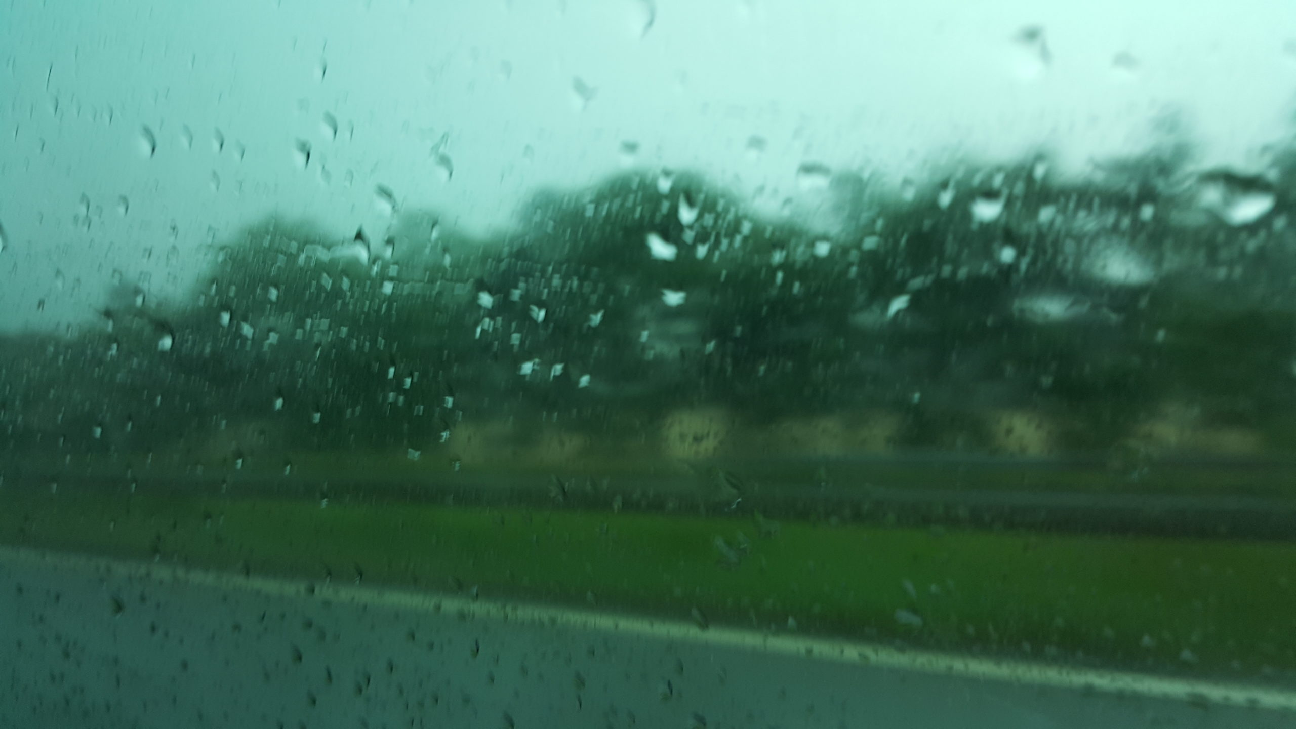
No silly grin, but coincidentally – perhaps by accident – I took a picture out of the car window shortly after we passed the hashpoint. This is what Lanark looks like when you drive through it in the rain.