Oxford Under Water

Parts of Oxford have been flooded for the last few days, and apparently the worst is yet to come. I worked from home yesterday, intimidated by the available choices of traversing flooded roads or else taking the hilly 3+ mile diversion around the problem areas, but today: I decided that it was time to man up and cycle in to the office.

Kennington Road underwater.
Here’s where I forded Kennington Road. Yes, I just used the word “forded” to describe crossing the road.

Conveniently, we’ve somewhere along the way acquired a large pair of Wellington boots (we think they might have been Paul‘s, but as he’s now left Oxford without them, they’ve been sitting in our charity-shop-box). So I booted up and set out. I was yawning all the way:

Police direct traffic away from a waterlogged Abingdon Road.

I had to weave my way back and forth around the cyclepaths nearest my house, and – on a couple of ocassions – get off the bike and wade it through: I’d considered riding through some of the larger puddles – my mean pedal-ground clearance is about as high as the top of my boots, anyway – until I met a soaked cyclist coming the other way: he’d become disbalanced going over a submarine kerbstone and fallen into the freezing water. Seeing that quickly made me choose the safer strategy!

Flood defences erected near Hinksey Lake.
Near Hinksey Lake, serious flood defences have been hastily erected and pumping operations are underway to clear gardens and footpaths.

Alongside the lake was one of the most flood-damaged areas, but heavy barriers had been erected and pumping engines were working at returning the water to the “right” side of them. The lake bridge was completely closed off: it looked like it might be traversable, but if the water gets any higher, it won’t be.

In Hinksey Park, the playing fields and cycle path are completely underwater.

I took the cycle route through Hinksey Park in order to avoid the flooded parts of Abingdon Road, which runs parallel, but I’m not sure that it was much better. In the photo above, you’d be forgiven for thinking that you’re looking at the lake… but in actual fact, the lake is behind me: that’s the playing fields. You can just about make out the line down the middle of the cycle path, through the murky water.

Flooded garden and driveway.
Between Hinksey Lake and the Thames there are flooded driveways and gardens. The sign on the gate reads “No parking. Keep entrance clear at all times.”, in case anybody was thinking of parking in this waist-deep water.

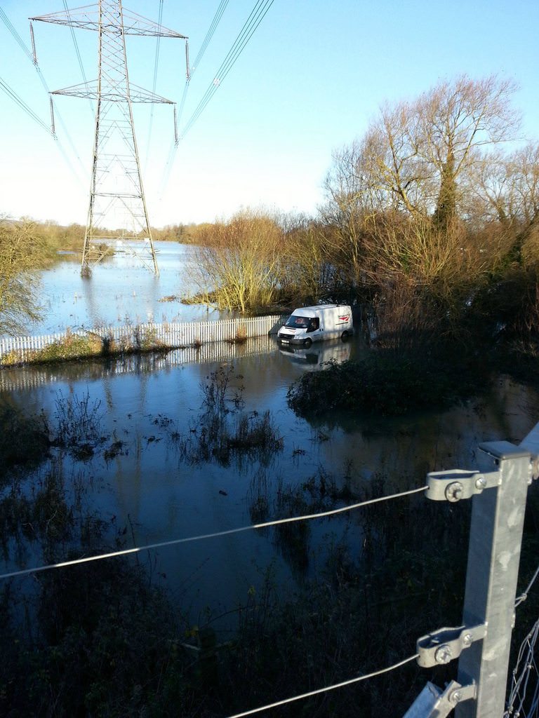
Pressing on, I came to the Thames Path, which my route typically follows for a short distance to the footbridge into the city centre. And that’s when I realised quite how high the river really is.

To the right of the bush - the river. To the left - the footpath. You'd be forgiven if you can't tell the difference.
To the right of the bush – the river. To the left – the footpath. You’d be forgiven if you can’t tell the difference.

By the time I found myself on a footpath with a current, I realised that my route might need a little bit of a rethink. With the bridge I was aiming for just ahead, though, I was able to double-back and cut through an alleyway (between some seriously at-risk houses), duck under a couple of “footpath closed” barriers, and splash out to the bridgehead.

From the bridge, it's clear how much the waters have risen.
From the bridge, it’s clear how much the waters have risen. The path on the left continues to get deeper and deeper underwater: when I’m working in a different office or running training, that’s the route I take to work!

By the time I was on the higher, better-reinforced East bank for the river, things began to improve, and within a few minutes I was right in the city centre. There, you wouldn’t know that, only a short distance away, a significant number of streets were underwater. To sit in the dry, on Broad Street, in the middle of Oxford, it seems strange to think that on the edge of town, people are being evacuated from their homes.

Further reading:

  • Flood warning for Kennington, from the Environment Agency (looks like we’re just on the right side of the road not to be included in the “flood warning area”).
  • “Live” upstream and downstream water level measurements at nearby Iffley Lock (there’s a beautiful moment in the graphs for yesterday morning when they clearly started using the lock itself to “dump” water downstream, occasionally bringing the level to within the typical range.
  • Video of evacuations from Botley
  • Jack FM’s Traffic Reports have an up-to-date list of roads closed as a result of flooding
Kennington Road underwater.× Police direct traffic away from a waterlogged Abingdon Road.× Flood defences erected near Hinksey Lake.× In Hinksey Park, the playing fields and cycle path are completely underwater.× Flooded garden and driveway.× To the right of the bush - the river. To the left - the footpath. You'd be forgiven if you can't tell the difference.× From the bridge, it's clear how much the waters have risen.×

Sand and seawater

This article is a repost promoting content originally published elsewhere. See more things Dan's reposted.

This repost was published in hindsight, on 11 March 2019.

Claire wrote:

Got up late, and spent the day on Ynyslas beach (A small town North of Aberystwyth, on the coast) with Paul, Kit, Fiona (Kit’s new girlfriend, as I’m sure he will relate in his next entry) and Dan. The water was warm, if a little shallow. We went for a swim, had a barbecue and watched the beautiful sunset. Pictures will be online soon enough. We climbed lazily back over the sand dunes to return to the car. Dan ran ahead, stopped at the crescent of a dune, and turned. “Drop your bag, take your keys, your car is underwater!” I thought he was joking.

So i wade into the now several inches deep water, just below the level of the exhaust pipe. Uncaring about getting sand in the car from my soaking shoes, I jump in and start the engine. I rev and rev, but my wheels are spinning and I’m digging myself deeper into the sand. Eventually, as the water continues to rise, some strangers come to my aid. (Dan had gone to get the others.) With about five people pushing and me panicking slightly less, the car was rescued and i drove it away from the water.
As I drove, very relieved indeed and driving cautiously in case the brakes had been damaged, a woman shouts at me. “Your lights are off!” she tells me. The least of my worries on an almost deserted beach after escaping a drowned vehicle! I flipped them on and waited for the rest of the crew.
We returned to aber, and laughed at our stupidity. Ok, my stupidity, I guess. This sort of thing only happens to me. We washed the salt water off the car and went back to the flat for beer and “Cannibal the Musical”. Hooray. A good day all round.

I’m considering giving my car bouyancy aids and an anchor.

Cool Thing Of The Day

Cool And Interesting Thing Of The Day To Do At The University Of Wales, Aberystwyth, #52:

Ride a train through water several feet deep, at 5mph, after the station at Dovey Junction becomes flooded, and, using traditional Welsh logic, it is decided that it makes far more sense to plough through it (making waves, for God’s sake!) than have to organise buses all day. Blurrgghh!

The ‘cool and interesting things’ were originally published to a location at which my “friends back home” could read them, during the first few months of my time at the University of Wales, Aberystwyth, which I started in September 1999. It proved to be particularly popular, and so now it is immortalised through the medium of my weblog.